
The Kyjov Hills (Czech: Kyjovská pahorkatina) is an area in the South Moravian Region of the Czech Republic. These relatively modest hills and undulating...
1 KB (125 words) - 00:43, 17 March 2024

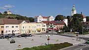
administrative parts of Kyjov. Kyjov is located about 17 kilometres (11 mi) north of Hodonín. Most of the municipal territory lies in the Kyjov Hills, only a small...
10 KB (889 words) - 08:06, 19 September 2024
Region Kyjov, a village and part of Krásná Lípa in the Ústí nad Labem Region Kyjov, a village and part of Zadní Chodov in the Plzeň Region Kyjov Hills, a...
694 bytes (133 words) - 11:04, 29 August 2023

Western Carpathians (Ždánice Forest, Kyjov Hills and Mikulov Hills) in the west and Bílé Karpaty and Chvojnice Hills in the east. The drainage to the Morava...
4 KB (337 words) - 23:43, 16 July 2023

Karpaty) Ždánice Forest (Ždánický les) Litenčice Hills (Litenčická pahorkatina) Chřiby Kyjov Hills (Kyjovská pahorkatina) (CZ/SK: Slovensko-moravské...
32 KB (2,939 words) - 20:48, 9 July 2024

southernmost part of the municipal territory extends into the Kyjov Hills. The highest point is the hill Kamenný kopec at 495 m (1,624 ft) above sea level. The...
7 KB (537 words) - 12:49, 18 September 2024

small western part of the municipal territory also extends into the Kyjov Hills. Staré Město is situated on the right bank of the Morava River, which...
8 KB (628 words) - 12:41, 18 September 2024

(southwest), Dyje–Svratka Valley (west), Ždánice Forest (north) and Kyjov Hills (small part in the northeast). The highest point of the district is the...
11 KB (752 words) - 10:08, 19 September 2024

(U Slepice) Litenčice Hills (Litenčická pahorkatina) IXB-2 590 293.7 518 (Hradisko) Chřiby IXB-3 335 342.6 587 (Brdo) Kyjov Hills (Kyjovská pahorkatina)...
17 KB (292 words) - 04:08, 24 July 2024

(southeast), Lower Morava Valley (a strip from southwest to north), Kyjov Hills (a strip from west to north) and Chřiby (northwest). The highest point...
12 KB (698 words) - 05:57, 23 August 2024
landscape of the Lower Morava Valley. The northern hilly part lies in the Kyjov Hills and include the highest point of Bzenec, Horní hory at 292 m (958 ft)...
9 KB (760 words) - 03:05, 13 September 2024

geomorphological mesoregions: Lower Morava Valley (southwest and centre), Kyjov Hills (a strip from west to east), Ždánice Forest (northwest), Chřiby (small...
11 KB (713 words) - 10:11, 19 September 2024

southwest of Zlín. It lies on the border between the Chřiby highlands and Kyjov Hills. The highest point is at 536 m (1,759 ft) above sea level. The Hruškovice...
6 KB (313 words) - 12:06, 18 September 2024

northwest of Hodonín and 39 km (24 mi) southeast of Brno. It lies in the Kyjov Hills. The highest point is at 324 m (1,063 ft) above sea level. The Prušánka...
6 KB (407 words) - 08:27, 11 September 2024

mostly in the Kyjov Hills, only the eastern part of the municipal territory lies in the Lower Morava Valley. The highest point is the hill Vyšicko at 267 m...
7 KB (477 words) - 08:18, 19 September 2024

Hradiště and 28 km (17 mi) southwest of Zlín. It lies mostly in the Kyjov Hills, only a small part of the municipal territory in the northwest extends...
5 KB (268 words) - 11:51, 18 September 2024

southern part extends into the Lower Morava Valley and Kyjov Hills. The highest point is the Tabulka hill at 298 m (978 ft) above sea level. The Trkmanka River...
6 KB (362 words) - 08:52, 10 September 2024

north of Hodonín and 38 km (24 mi) southeast of Brno. It lies in the Kyjov Hills. The highest point is at 319 m (1,047 ft) above sea level. The brook...
5 KB (263 words) - 11:07, 11 September 2024

It lies on the border between the Chřiby highlands and Kyjov Hills. The highest point is the hill Holý kopec at 548 m (1,798 ft) above sea level. The streams...
7 KB (524 words) - 11:52, 18 September 2024

Valley. The northern half lies in the Kyjov Hills and includes the highest point of Velké Bílovice, the Zimarky hill (also called Hradištěk) at 264 m (866 ft)...
11 KB (891 words) - 08:51, 10 September 2024

west of Hodonín and 44 km (27 mi) southeast of Brno. It lies in the Kyjov Hills. The highest point is at 262 m (860 ft) above sea level. The first written...
7 KB (372 words) - 11:08, 11 September 2024

and 47 km (29 mi) southeast of Brno. It lies on the border between the Kyjov Hills and Lower Morava Valley. The highest point is at 278 m (912 ft) above...
5 KB (238 words) - 08:27, 11 September 2024

the Ždánice Forest, but it also extends into the Kyjov Hills in the east. The highest point is the hill Kobylí vrch at 334 m (1,096 ft) above sea level...
5 KB (310 words) - 08:06, 10 September 2024

Valley. The northern hilly part lies in the Kyjov Hills and include the highest point of Vracov, a hill at 311 m (1,020 ft) above sea level. Vracovský...
6 KB (403 words) - 11:50, 11 September 2024

and 48 km (30 mi) southeast of Brno. It lies on the border between the Kyjov Hills and Lower Morava Valley. The highest point is at 260 m (850 ft) above...
5 KB (308 words) - 11:06, 11 September 2024
Morava Valley, The northern part of the municipal territory lies in the Kyjov Hills and includes the highest point of Moravský Žižkov at 260 m (850 ft) above...
5 KB (232 words) - 08:44, 10 September 2024

southern part on the municipal territory lies in the Kyjov Hills. The highest point is the hill U Slepice at 439 m (1,440 ft) above sea level. The Trkmanka...
6 KB (343 words) - 11:51, 11 September 2024

Hodonín and 41 km (25 mi) southeast of Brno. It lies in the Kyjov Hills. The highest point is the hill Záviště at 256 m (840 ft) above sea level. The Kyjovka...
6 KB (334 words) - 08:06, 19 September 2024

southwest of Zlín. The western part of the municipal territory lies in the Kyjov Hills and the eastern part lies in the Lower Morava Valley. The highest point...
5 KB (304 words) - 12:07, 18 September 2024

only the southernmost part of the municipal territory extends into the Kyjov Hills. The highest point is at 297 m (974 ft) above sea level. The built-up...
6 KB (384 words) - 12:02, 18 September 2024