The LORAN-C transmitter Jan Mayen was a LORAN-C transmission facility on the island of Jan Mayen at 70°54′51″N 8°43′57″W / 70.91417°N 8.73250°W / 70...
2 KB (214 words) - 14:44, 2 August 2023
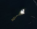
Galileo on Jan Mayen. There was also an earlier Jan Mayen LORAN-C Transmitter, but the transmitter is now decommissioned and demolished. Jan Mayen Radio was...
52 KB (5,285 words) - 20:10, 6 August 2024
Svalbard and Jan Mayen (Norwegian: Svalbard og Jan Mayen, ISO 3166-1 alpha-2: SJ, ISO 3166-1 alpha-3: SJM, ISO 3166-1 numeric: 744) is a statistical designation...
12 KB (1,132 words) - 22:27, 27 April 2023

Loran-C is a hyperbolic radio navigation system that allows a receiver to determine its position by listening to low frequency radio signals that are...
87 KB (9,388 words) - 14:38, 18 August 2024
connection with the LORAN-C transmitter at Olonkinbyen and was completed in 1960. Jan Mayensfield is served eight times per year by Lockheed C-130 Hercules aircraft...
9 KB (800 words) - 23:06, 29 May 2024

Trollsletta (category Landforms of Jan Mayen)
only settlement on Jan Mayen, Olonkinbyen consists of a weather station and the Norwegian Armed LORAN-C station. "Trollsletta (Jan Mayen)". Norwegian Polar...
2 KB (168 words) - 02:10, 25 November 2023
broadcasting antennas fell down, height afterwards 274 metres LORAN-C transmitter Jan Mayen, Jan Mayen, Norway October 8, 1980 Guyed mast of lattice steel 190...
50 KB (1,044 words) - 23:07, 9 August 2024

Kjerulf Glacier (Norwegian: Kjerulfbreen) is a glacier in Jan Mayen. It begins at the Hakluyttoppen slope, in the outer crater edge of the Beerenberg...
2 KB (190 words) - 22:26, 23 March 2023

Sørkapp (South Cape) is the southernmost point of the island Jan Mayen. The cape is some 455 km east of eastern Greenland, 910 km west northwest of mainland...
844 bytes (63 words) - 16:29, 16 September 2023

Kapp Wien (category Headlands of Jan Mayen)
of Jan Mayen, about halfway between Olonkinbyen and Sørkapp. It defines the northeastern extension of the bay Hornbækbukta. "Kapp Wien (Jan Mayen)". Norwegian...
961 bytes (89 words) - 16:27, 16 September 2023
63500; 14.46306 (Bø LORAN-C transmitter) Insulated against ground LORAN-C transmitter Jan Mayen 190 m 623 ft Guyed mast Jan Mayen, Arctic Ocean 70°54′51...
15 KB (42 words) - 01:22, 28 May 2024

Weyprecht Glacier (category Glaciers of Jan Mayen)
and Jan Mayen "Weyprechtbreen". Mapcarta. Retrieved 18 March 2019. Weyprecht Glacier, Jan Mayen - Geographical Names Glacier retreat in Jan Mayen Glaciers...
2 KB (67 words) - 19:56, 4 May 2021
phase-difference of three transmitters. Later, Omega elaborated on this principle. For Loran-C, introduced in the late 1950s, all transmitters broadcast pulses...
78 KB (10,589 words) - 08:35, 24 April 2024
Rudolftoppen (category Landforms of Jan Mayen)
Jan Mayen. It has a height of 769 m.a.s.l., and is the highest peak in the southern part of the island. Arctic Pilot: Sailing directions Svalbard–Jan...
784 bytes (83 words) - 11:38, 5 March 2021
5215111; -6.0300167, call sign SL, frequency 311 then 315 kHz Jan Mayen Island, Svalbard and Jan Mayen 70°58′25″N 8°29′43″W / 70.97361°N 8.49528°W / 70.97361;...
21 KB (3,148 words) - 04:49, 16 September 2023