
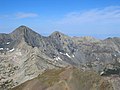
La Veta Pass is the name associated with two nearby mountain passes in the Sangre de Cristo Mountains of south central Colorado in the United States,...
4 KB (382 words) - 00:24, 1 January 2024

La Veta (/ləˈvitə/ lə-VEE-tə, Spanish for "the vein") is a statutory town in Huerfano County, Colorado, United States. La Veta sits at the base of the...
16 KB (991 words) - 18:46, 24 August 2024

The La Veta Pass Narrow Gauge Railroad Depot, in La Veta, Colorado, was built in 1877 for the Denver & Rio Grande. It was listed on the National Register...
2 KB (167 words) - 17:12, 23 July 2024

mountains extend southeast from Poncha Pass for about 75 mi (121 km) through south-central Colorado to La Veta Pass, approximately 20 mi (32 km) west of...
17 KB (1,295 words) - 10:00, 27 June 2024

from Walsenburg, Colorado, over La Veta Pass (now "Old La Veta Pass") by 1877. At the time the 'Uptop' depot on Veta Pass, rising over 9,500 feet (2,900 m)...
39 KB (4,574 words) - 00:06, 11 June 2024

of their apex stations. Fremont Pass, for example, is not named Climax Pass; nor is La Veta Pass referred to as Fir Pass. The elevation of '11,660 feet'...
214 KB (19,020 words) - 16:08, 25 August 2024

pass crosses the Continental Divide of the Americas. Cottonwood Pass is normally closed from about November 7 through about May 25. Independence Pass...
53 KB (720 words) - 17:24, 8 July 2024

Kingman Pass, Wyoming Kings Hill Pass, Montana Kokomo Pass, Colorado La Manga Pass, Colorado La Poudre Pass, Colorado La Veta Pass, Colorado Lake Pass, Colorado...
43 KB (3,236 words) - 20:26, 25 July 2024
and Rio Grande Railroad, which was chartered in 1870. The line over La Veta Pass to Alamosa and Antonito was originally envisioned as part of an ambitious...
15 KB (1,416 words) - 16:11, 31 December 2023
rift, extending southeast from Poncha Pass for about 75 miles (120 km) through south-central Colorado to La Veta Pass, approximately 20 miles (32 km) west...
21 KB (1,599 words) - 08:07, 1 April 2024

north of U.S. Highway 160 one half mile (800 m) northwest of North La Veta Pass. The pass separates Costilla County from Huerfano County, the Rio Grande drainage...
2 KB (206 words) - 22:28, 5 April 2021

the first town one encounters when traveling west having crossed over La Veta Pass in the Sangre de Cristo Range. Fort Garland is home to many artists,...
12 KB (582 words) - 02:26, 17 October 2023

a connection with the Union Pacific Railroad at Walsenburg, CO, over La Veta Pass and into the fertile San Luis Valley. At Alamosa the railroad splits...
32 KB (2,985 words) - 16:53, 10 June 2024

on the SLRG's former Denver and Rio Grande Western La Veta Pass line between Alamosa and La Veta. The No. 18 locomotive last operated under RGSR ownership...
28 KB (3,164 words) - 01:31, 2 July 2024

Denver and Rio Grande Railroad was chartered in 1870. The line over La Veta Pass to Alamosa and Antonito was originally envisioned as part of an ambitious...
12 KB (1,197 words) - 00:29, 4 February 2024

(58 km) to Trinidad. U.S. Route 160 passes through the center of Walsenburg, leading west across North La Veta Pass 72 miles (116 km) to Alamosa and south...
26 KB (1,552 words) - 16:38, 18 August 2024

There are several passes, with elevations between 9,000 and 10,000 feet (2,700 and 3,000 m), giving access to the valley. North La Veta Pass, through the Sangre...
44 KB (5,269 words) - 14:37, 26 August 2024

starts atop La Veta Pass in the Sangre de Cristo Mountains. The creek flows alongside Highway 160 as it descends from the top of the pass into the San...
2 KB (166 words) - 11:02, 1 October 2022

state, due to its separation from other peaks by the relatively low La Veta Pass. According to the current owners of Cielo Vista Ranch, within which the...
6 KB (393 words) - 01:21, 3 October 2023

fire Yuma County, Colorado 2006 13,820 acres (5,590 ha) Mato Vega fire La Veta Pass, Colorado 2008 8,900 acres (3,600 ha) Ordway fire Ordway, Colorado Killed...
45 KB (1,494 words) - 15:09, 2 August 2024
Chivington, a hero of the Battle of Glorieta Pass and the perpetrator of the Sand Creek Massacre. Located at Tennessee Pass at an elevation of 11,342 feet (3,457 m)...
98 KB (2,402 words) - 18:53, 5 August 2024
of mountain passes Rocky Mountains Canadian Rockies Central Rocky Mountains Western Rocky Mountains Southern Rocky Mountains Mountain pass List of mountain...
104 KB (294 words) - 15:14, 5 April 2024

valley. Although many settlers arrived via the trails from Santa Fe or La Veta Pass, several routes over the Sangre de Cristos into the valley were well-known...
76 KB (8,165 words) - 16:09, 26 August 2024

Tunnel; Union Pacific (originally D&SL). Fir Loop; near the summit of La Veta Pass; San Luis and Rio Grande Railroad (originally D&RG). Horseshoe curves...
15 KB (1,804 words) - 17:27, 8 August 2024

of the Spanish Peaks, through Sangre de Cristo Pass (west of Walsenburg, Colorado), Old La Veta Pass and into Questa area (NM 522/NM38 area). It came...
13 KB (1,554 words) - 00:44, 5 August 2024

Southern Rocky Mountains (section Mountain passes)
divided from the Central Rocky Mountains by South Pass in Wyoming and the drainage running east from the pass down the Sweetwater River and the North Platte...
58 KB (5,092 words) - 17:20, 8 July 2024

gun.: 12–14 On the morning of 8 November, at the Oakview Mine, in the La Veta Pass and near the pro-union town of the same name, pro-union men began harassing...
112 KB (12,049 words) - 00:14, 25 August 2024

U.S. Route 160 in Colorado (category Transportation in La Plata County, Colorado)
into Alamosa. It turns east, then goes northeast to go through North La Veta Pass, then continues east to Walsenburg, where it intersects Interstate 25...
12 KB (480 words) - 00:19, 15 June 2024

southeast (bearing 131°) of North La Veta Pass in Huerfano County, Colorado, United States. The mountain was known as La Veta Peak until 1949 when it was renamed...
3 KB (224 words) - 12:44, 18 October 2023
through the San Luis Valley, crossed the Sangre de Cristo Mountains at La Veta Pass, and descended to the Great Plains. He traded the whiskey for buffalo...
6 KB (748 words) - 00:54, 12 April 2024