
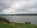
Lac de Naussac is a lake in Lozère, France. At an elevation of 945 m, its surface area is 10.8 km². v t e...
1 KB (25 words) - 11:25, 22 October 2020
Naussac (French pronunciation: [nosak]; Occitan: Naussac, Nauçac, or Nonçac) is a former commune in the Lozère departement in southern France. On 1 January...
2 KB (79 words) - 13:20, 22 August 2024
List of lakes of France (redirect from Liste des lacs de France)
d'Avène Lac du Tolerme Étang de Barrandon Lac de Ganivet Lac du Moulinet Lac de Naussac Lac de Villefort Étang de Lachamp Gour de Tazenat (V) Lac d'Aydat...
19 KB (2,501 words) - 15:55, 17 June 2024

middle of the commune. The Colagne has its source in the commune; with the Lac de Charpal they form most of the commune's southwestern border. Communes of...
2 KB (103 words) - 13:09, 23 November 2023

Villefranche-de-Panat (French: [vilfʁɑ̃ʃ də pana]; Occitan: Vilafranca de Panat [ˌbilɔˈfɾaŋkɔ ðe paˈnat]) is a commune located in the Aveyron department...
2 KB (78 words) - 13:17, 24 August 2024

some small patches of forest. The eastern border of the commune is the Lac de Pareloup. The Céor river rises in the east of the commune and flows west...
11 KB (856 words) - 13:10, 24 August 2024

Las Salas) is a commune in the Aveyron department in southern France. The lac de Pareloup forms part of the commune's northern border. The river Céor has...
2 KB (95 words) - 13:16, 24 August 2024

Mende, Lozère (category Articles with German-language sources (de))
drinking water of the city of Mende comes from this direction, because of the Lac de Charpal reservoir, which is the main source. In 2017, Mende had 6,851 residences...
129 KB (14,482 words) - 10:19, 21 August 2024

Pourquairol, the stream of Ricardel, and by several small courses of water. The Lac de Pinet completes the hydrographic network. It is related to a very wild lake...
6 KB (454 words) - 13:16, 24 August 2024

south-east to Villefranche-de-Panat. Access to the village is from the north-east on road D659 which runs off the D577 south of the Lac de Pareloup. The D659...
6 KB (426 words) - 12:10, 22 August 2024
in southern France. The Colagne and the lac de Charpal form part of the commune's northern border. Arboretum de Born Communes of the Lozère department...
2 KB (95 words) - 13:19, 22 August 2024
the Lévézou plateau delivered by penstocks from the Lac de Villefranche-de-Panat and the Lac de Saint-Amans both at 727 m. Le Pouget delivers 440 MW...
4 KB (275 words) - 13:17, 24 August 2024