
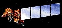
Landsat 7 is the seventh satellite of the Landsat program. Launched on 15 April 1999, Landsat 7's primary goal is to refresh the global archive of satellite...
14 KB (1,369 words) - 03:01, 26 August 2024
eventually renamed to Landsat 1 in 1975. The most recent, Landsat 9, was launched on 27 September 2021. The instruments on the Landsat satellites have acquired...
41 KB (3,817 words) - 05:15, 6 September 2024

Landsat Island is a small, uninhabited island located at approximately 60°10'37"N 64°02'30"W, 20 kilometres (12 mi) off the northeast coast of Labrador...
3 KB (400 words) - 21:44, 6 October 2024

Landsat 9 is an Earth observation satellite launched on 27 September 2021 from Space Launch Complex-3E at Vandenberg Space Force Base on an Atlas V 401...
10 KB (859 words) - 11:31, 24 September 2024

officially renamed to Landsat 8. With Landsat 5 retiring in early 2013, leaving Landsat 7 as the only on-orbit Landsat program satellite, Landsat 8 ensures the...
23 KB (2,255 words) - 19:27, 15 May 2024

Landsat 5 was a low Earth orbit satellite launched on March 1, 1984, to collect imagery of the surface of Earth. A continuation of the Landsat Program...
11 KB (1,119 words) - 23:11, 22 July 2024

Satellite imagery (section Landsat)
the Landsat archive offers repeated imagery at 30 meter resolution for the planet, but most of it has not been processed from the raw data. Landsat 7 has...
31 KB (3,471 words) - 04:17, 22 August 2024

remote sensing instrument aboard Landsat 8, built by Ball Aerospace & Technologies. Landsat 8 is the successor to Landsat 7 and was launched on February 11...
6 KB (608 words) - 18:24, 17 May 2024

Landsat 1 (LS-1), formerly named ERTS-A and ERTS-1, was the first satellite of the United States' Landsat program. It was a modified version of the Nimbus...
12 KB (1,139 words) - 12:58, 9 April 2024
Landsat 6, equipped with upgraded versions of the instruments on Landsat 5, was designed to carry forward the Landsat program. It was launched on October...
5 KB (368 words) - 23:34, 25 April 2024

braided streams or settles into pools and ponds. Along the bottom of the Landsat 7 image on the right, the rugged terrain of the Brooks Range mountains is...
10 KB (1,053 words) - 21:18, 26 July 2024

Generation imagery Landsat 7 imagery NLT Landsat (Visible & Pseudo Color) Geocover 1990 & 2000 (pseudo; 1990 layer was produced from Landsat 4 & 5 images)...
20 KB (1,994 words) - 19:35, 15 September 2024
completed Landsat 4, launched July 1982, completed Landsat 5, launched March 1984, completed Landsat 6, launched October 1993, failed Landsat 7, launched...
48 KB (3,953 words) - 15:41, 14 October 2024
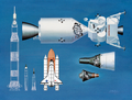
objective of the concept mission and spacecraft was the complex refueling of Landsat 7, a satellite launched in 1999, that was not designed for on-orbit servicing...
6 KB (673 words) - 19:23, 5 September 2024

satellite imagery. Unlike later Landsat satellites, Landsat 3 was managed solely by NASA. Landsat 3 decommissioned on September 7, 1983, beyond its design life...
12 KB (1,291 words) - 13:10, 19 November 2023
Landsat 7 image Brandberg Mountain, Namibia...
13 KB (1,113 words) - 12:22, 30 September 2024
Landsat 4 is the fourth satellite of the Landsat program. It was launched on July 16, 1982, with the primary goal of providing a global archive of satellite...
12 KB (1,237 words) - 15:57, 3 October 2024

type of sensor expensive and more prone to wearing out, such as in the Landsat 7. Whisk broom scanners have the effect of stopping the scan, and focusing...
2 KB (191 words) - 16:21, 14 January 2024

""Taklamakan" Adının Kökeni Üzerine". Korkut Ata Türkiyat Araştırmaları Dergisi (7): 572–577. doi:10.51531/korkutataturkiyat.1070366. ISSN 2687-5675. S2CID 248487312...
27 KB (2,342 words) - 13:22, 9 September 2024

Landsat 7 false-color image of the Sydney area and surrounding suburbs. The image demonstrates how the built-up areas (pink) have been constrained by...
26 KB (1,307 words) - 11:32, 10 August 2024
Before the launch of NASA and the USGS's Landsat 8 satellite, Google relied partially on imagery from Landsat 7, which suffered from a hardware malfunction...
94 KB (8,564 words) - 19:08, 15 October 2024
combinations are commonly bundled in satellite data sets, for example Landsat 7, which includes six 30 m resolution multispectral bands, a 60 m thermal...
4 KB (498 words) - 00:36, 1 June 2024
of hurricanes. Notable pairs are GRACE and GRACE-Follow On satellites, Landsat 7 with EO-1, the "A-train" consisting of CALIPSO and CloudSat (among others)...
5 KB (466 words) - 13:21, 5 October 2023
complex landscape in Kazakhstan: An object-based approach using SPOT-5 XS, Landsat 7 ETM+, SRTM and multiple Random Forests". International Journal of Applied...
11 KB (1,310 words) - 23:49, 31 January 2024

Italy), by E. St. John Hart, article in Pearson's Magazine, February 1903 Landsat 7 photograph of Carrara marble quarries in August 2001 Overnight in Carrara...
14 KB (1,284 words) - 13:36, 27 September 2024

The strait is 61 kilometres (38 mi) long, and 1.2 to 6 kilometres (0.7 to 3.7 mi) wide, averaging 55 metres (180 ft) deep with a maximum depth of 103...
27 KB (2,982 words) - 13:49, 22 July 2024
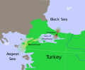
View of the Dardanelles, taken from the Landsat 7 satellite in September 2006. The body of water at the upper left is the Aegean Sea, while the one on...
12 KB (1,147 words) - 21:32, 2 May 2024

/ Mount Cook", is a tourist centre and base camp for the mountain. It is 7 km from the end of the Tasman Glacier and 15 km south of Aoraki / Mount Cook's...
30 KB (3,330 words) - 05:00, 16 August 2024

in permafrost of an upper dry valley, Antarctica". The ISME Journal. 10 (7): 1613–1624. Bibcode:2016ISMEJ..10.1613G. doi:10.1038/ismej.2015.239. PMC 4918446...
20 KB (2,017 words) - 16:26, 6 October 2024