
Le Havre Seine Métropole is the communauté urbaine, an intercommunal structure, centred on the city of Le Havre. It is located in the Seine-Maritime department...
6 KB (407 words) - 02:18, 26 April 2024

Le Havre (/lə ˈhɑːv(rə)/ lə HAHV(-rə); French: [lə ɑvʁ(ə)] ; Norman: Lé Hâvre [lɛ ˈhɑvʁ(ə)]) is a major port city in the Seine-Maritime department in the...
140 KB (15,610 words) - 00:55, 3 September 2024

Jean-Baptiste Gastinne (category Politicians from Le Havre)
Métropole". Le Havre Seine Métropole (in French). Retrieved 2021-08-14. "Le Havre Seine Métropole | RTES". www.rtes.fr. Retrieved 2021-08-14. "Le président...
9 KB (753 words) - 08:13, 5 December 2022

for Seine-Maritime's 7th constituency from 2007 to 2012. In 2008, he was elected to the general council of Seine-Maritime in the canton of Le Havre-5,...
37 KB (2,745 words) - 09:05, 9 September 2024

Seine-Maritime. The communes cooperate in the following intercommunalities (as of 2020): Métropole Rouen Normandie Communauté urbaine Le Havre Seine Métropole...
33 KB (151 words) - 20:37, 28 December 2022
Quevillaise-Rouen Métropole, known as US Quevilly-Rouen, US Quevilly, QRM, Quevilly-Rouen, or simply Quevilly, is a football club based in Le Petit-Quevilly...
17 KB (1,625 words) - 11:59, 20 August 2024

new communauté urbaine Le Havre Seine Métropole on 1 January 2019. Its population was 239,806 in 2015, of which 174,911 in Le Havre proper. The communauté...
5 KB (121 words) - 00:13, 26 May 2024

Harfleur (category Communes of Seine-Maritime)
on the eastern edge of Le Havre's urban area. A light industrial town situated in the Pays de Caux by the banks of the Seine and Lézarde rivers, some...
12 KB (1,380 words) - 10:45, 21 August 2024

Luc Lemonnier (category Politicians from Le Havre)
pronunciation: [lyk ləmɔnje]; born May 22, 1968 in Le Havre) is a French politician, mayor of Le Havre from 2017 to 2019. Luc Lemonnier spent part of his...
11 KB (862 words) - 20:20, 25 August 2024
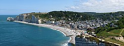
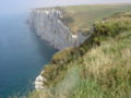
Étretat (category Communes of Seine-Maritime)
is a tourist and farming town situated about 32 km (20 mi) northeast of Le Havre, at the junction of the D 940, D 11 and D 139 roads. It is located on the...
12 KB (1,112 words) - 10:25, 21 August 2024
integrated form of intercommunality in France, after the Metropolis (French: métropole). A communauté urbaine is composed of a city (commune) and its independent...
5 KB (363 words) - 09:32, 15 October 2023
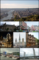
Rouen (redirect from Rouen, Seine-Maritime)
own airport. The Seine is a major axis for maritime cargo links in the Port of Rouen. The Cross-Channel ferry ports of Caen, Le Havre, Dieppe (50 minutes)...
41 KB (3,815 words) - 04:25, 29 August 2024
Communauté de Communes du Canton de Criquetot-l'Esneval (category Former commune communities of Seine-Maritime)
December 2001. and it was merged into the new communauté urbaine Le Havre Seine Métropole on 1 January 2019. The communauté de communes consisted of the...
2 KB (145 words) - 11:05, 30 March 2022

Saint-Jouin-Bruneval (category Le Havre geography stubs)
north of Le Havre, at the junction of the D940, D139 and D111 roads. France's 2nd largest oil-tanker port (built 1973-1975) and oil depot of ‘’Havre-Antifer’’...
3 KB (174 words) - 12:50, 25 August 2024

Paris (redirect from Paris, Banks of the Seine)
2015-1212 du 30 septembre 2015 constatant le périmètre fixant le siège et désignant le comptable public de la métropole du Grand Paris" [Decree n° 2015-1212...
245 KB (24,021 words) - 20:25, 9 September 2024

Montivilliers (redirect from Montivilliers, Seine-Maritime)
river Lézarde in the Pays de Caux, situated just 4 miles (6.4 km) north of Le Havre, at the junction of the D489, D52, D926 and D31 roads. Pre-Roman archaeological...
5 KB (362 words) - 11:39, 21 August 2024

village situated in the Pays de Caux, some 13 miles (21 km) northeast of Le Havre, on the D239 road. The church of Notre-Dame, dating from the sixteenth...
2 KB (106 words) - 14:50, 25 August 2024

Saint-Vincent-Cramesnil (category Le Havre geography stubs)
farming village, in the Pays de Caux, situated some 12 miles (19 km) east of Le Havre, at the junction of the D10 and D80 roads. It's on the route of the Tour...
2 KB (156 words) - 10:34, 21 August 2024

farming village situated in the Pays de Caux, some 9 miles (14 km) north of Le Havre, on the D111 road. The church of St.Michel, dating from the eleventh century...
3 KB (120 words) - 14:50, 25 August 2024
village situated in the Pays de Caux, some 11 miles (18 km) northeast of Le Havre, at the junction of the D80 and D31 roads. Junction 6 of the A29 autoroute...
3 KB (161 words) - 15:19, 25 August 2024

Seine-Maritime department in the Normandy region in northern France. A farming village situated in the Pays de Caux, some 9 miles (14 km) north of Le...
2 KB (145 words) - 15:20, 25 August 2024

Sandouville (category Le Havre geography stubs)
the Seine, in the Pays de Caux, situated some 11 miles (18 km) east of Le Havre, at the junction of the D80 and D982 roads. The commune has two distinct...
3 KB (163 words) - 12:43, 25 August 2024

Le Dauphiné Libéré (Dauphiné, Savoy) Le Havre libre (Seine-Maritime) Le Havre presse (Seine-Maritime) Le Journal de l'île de la Réunion (Réunion) Le Journal...
25 KB (2,076 words) - 11:52, 12 August 2024
of Le Havre, just off the D32 road. The church of St. Thomas, dating from the eighteenth century. Traces of a medieval castle. Communes of the Seine-Maritime...
2 KB (98 words) - 09:45, 3 August 2022

Criquetot-l'Esneval (category Le Havre geography stubs)
town situated in the Pays de Caux, some 15 miles (24 km) northeast of Le Havre, at the junction of the D139, D239 and D79 roads. The two 16th century...
3 KB (142 words) - 12:51, 25 August 2024
village situated in the Pays de Caux, some 20 miles (32 km) northeast of Le Havre, at the junction of the D11 and D72 roads and on the coast of the English...
3 KB (162 words) - 12:52, 25 August 2024

La Poterie-Cap-d'Antifer (category Communes of Seine-Maritime)
A farming village in the Pays de Caux, some 12 miles (19 km) north of Le Havre, at the junction of the D111 and D950 roads. The commune borders the English...
3 KB (224 words) - 11:53, 30 August 2022

Gonfreville-l'Orcher (category Le Havre geography stubs)
ancient village situated in the Pays de Caux, some 5 miles (8.0 km) east of Le Havre, in between the D982 and D9015 roads. The A131 autoroute cuts through the...
4 KB (363 words) - 14:50, 25 August 2024

Le Tilleul (French pronunciation: [lə tijœl]) is a commune in the Seine-Maritime department in the Normandy region in northern France. A farming village...
3 KB (144 words) - 14:54, 25 August 2024

of Le Havre, at the junction of the D9015, D34 and D910 roads. The church of St. Pierre, dating from the thirteenth century. Communes of the Seine-Maritime...
3 KB (118 words) - 16:08, 5 November 2023