
The Ozark administrative region of the Missouri Department of Conservation encompasses Carter, Dent, Douglas, Howell, Oregon, Ozark, Phelps, Pulaski,...
38 KB (101 words) - 20:20, 9 April 2022

The Ozarks, also known as the Ozark Mountains, Ozark Highlands or Ozark Plateau, is a physiographic region in the U.S. states of Missouri, Arkansas, Oklahoma...
68 KB (6,903 words) - 19:06, 13 September 2024

The Missouri Department of Conservation (MDC) administers hundreds of parcels of land in all counties of the state. Most areas are owned by the department;...
9 KB (417 words) - 16:57, 9 February 2024
44 List of Missouri conservation areas – Ozark region Ozark Henry, a Belgian musician Ozark Ripley, an American fisherman and huntsman Danny Ozark, an...
2 KB (300 words) - 16:35, 25 July 2024
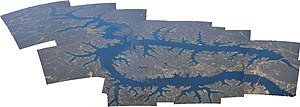
Lake of the Ozarks is a reservoir created by impounding the Osage River in the northern part of the Ozarks in central Missouri. Parts of three smaller...
34 KB (3,191 words) - 14:53, 21 August 2024

the southeastern portion of the Ozarks of Missouri and becomes a 7th order stream as it flows southeasterly out of the Ozarks into northeastern Arkansas...
10 KB (836 words) - 02:54, 25 July 2023

This list includes Conservation Areas, Wildlife Areas, and other natural places administered under the central administrative region of the Missouri Department...
50 KB (168 words) - 18:27, 9 February 2024

The Northeast administrative region of the Missouri Department of Conservation encompasses Adair, Clark, Knox, Lewis, Macon, Marion, Monroe, Pike, Putnam...
34 KB (103 words) - 20:20, 9 April 2022
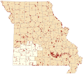
The Southeast administrative region of the Missouri Department of Conservation encompasses Bollinger, Butler, Cape Girardeau, Dunklin, Iron, Madison,...
41 KB (109 words) - 07:47, 21 June 2022

National Scenic Byways cross the Ozark–St. Francis National Forest, including the Scenic 7 Byway which runs from Missouri to Louisiana, 60 miles (100 km)...
10 KB (863 words) - 11:01, 6 September 2024

The Northwest administrative region of the Missouri Department of Conservation encompasses Andrew, Atchison, Buchanan, Caldwell, Carroll, Chariton, Clinton...
46 KB (123 words) - 20:20, 9 April 2022
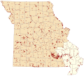
The Southwest administrative region of the Missouri Department of Conservation encompasses Barry, Barton, Cedar, Christian, Dade, Dallas, Greene, Hickory...
45 KB (104 words) - 18:59, 5 May 2023

The St. Louis administrative region of the Missouri Department of Conservation encompasses Crawford, Franklin, Jefferson, Lincoln, St. Charles, St. Louis...
34 KB (100 words) - 19:41, 10 June 2022

The Kansas City administrative region of the Missouri Department of Conservation encompasses Bates, Benton, Cass, Clay, Henry, Jackson, Johnson, Lafayette...
47 KB (103 words) - 18:13, 9 May 2023
within Missouri, with a part in Arkansas and small sections in Oklahoma and Kansas. It is the largest subdivision of the region known as the Ozark Mountains...
15 KB (1,937 words) - 23:12, 17 June 2024
Cave region Michigan Presque Isle County near and around Rogers City Pictured Rocks National Lakeshore near Munising, Michigan Missouri, Arkansas Ozark Plateau...
22 KB (1,960 words) - 19:31, 20 August 2024

This list of caves in Missouri includes the location and date they were opened to the public (or discovered). The Ozarks region has a well-developed karst...
2 KB (164 words) - 03:58, 7 March 2022

Joplin, Missouri Metropolitan Statistical Area, a region with an estimated 176,849 (2011) residents. Neosho lies on the western edge of the Ozarks, in the...
62 KB (7,056 words) - 11:33, 5 August 2024
Missouri (/mɪˈzʊəri/ miz-OOR-ee) is a double landlocked state in the Midwestern region of the United States. Ranking 21st in land area, it borders Iowa...
155 KB (14,328 words) - 11:55, 13 September 2024

Maramec Spring (redirect from Meramec Springs, Missouri)
east-central Ozarks of Missouri. The fifth largest spring in the state with an average discharge of 153 cubic feet (4.3 m3) of water per second, it is part of a...
9 KB (623 words) - 23:45, 28 August 2024

Springfield Plateau of the Ozarks region of southwest Missouri. According to the United States Census Bureau, the city has a total area of 82.31 square miles...
97 KB (9,713 words) - 03:34, 7 September 2024

Hellbender (category IUCN Red List vulnerable species)
2010). "Genetic relationships of hellbenders in the Ozark highlands of Missouri and conservation implications for the Ozark subspecies (Cryptobranchus alleganiensis...
46 KB (5,238 words) - 15:18, 4 September 2024

an area of 35.69 square miles (92.41 km2) on the outer edge of the Ozark Mountains. Joplin is the main hub of the three-county Joplin-Miami, Missouri-Oklahoma...
63 KB (6,701 words) - 21:55, 22 August 2024

Metropolitan Area and Fort Smith metropolitan area, with sparsely populated mountainous areas defining the remainder of the region. The Ozark culture, such...
39 KB (3,450 words) - 22:00, 4 August 2024

Niangua River (category Lake of the Ozarks)
tributary of the Osage River in the Ozarks region of southern and central Missouri in the United States. Via the Osage and Missouri rivers it is part of the...
7 KB (552 words) - 16:48, 9 July 2023

Northwest Arkansas (redirect from Fayetteville-Springdale-Rogers metropolitan area)
Northwest Arkansas (NWA) is a metropolitan area and region in Arkansas within the Ozark Mountains. It includes four of the ten largest cities in the state:...
68 KB (6,592 words) - 01:30, 12 September 2024

Bass Pro Shops (category 1972 establishments in Missouri)
few years later in 1987, Morris bought an empty plot of land on Table Rock Lake in Missouri's Ozark Mountains. One year later, at that location, he opened...
52 KB (4,723 words) - 12:54, 4 September 2024

the Missouri River, between the Ozark Plateau and the Northern Plains. According to the United States Census Bureau, the city has a total area of 67.45...
95 KB (8,784 words) - 08:54, 11 September 2024

Carter County is a county in the Ozarks of Missouri. At the 2020 census, it had a population of 5,202. The largest city and county seat is Van Buren. The...
68 KB (6,968 words) - 08:44, 30 August 2024

Sam A. Baker State Park (category Protected areas of Wayne County, Missouri)
is a public recreation area encompassing 5,323 acres (2,154 ha) in the Saint Francois Mountains region of the Missouri Ozarks. The state park offers fishing...
7 KB (517 words) - 06:20, 6 December 2023