
The Litavka is a river in the Czech Republic, a right tributary of the Berounka River. It flows through the Central Bohemian Region. It is 54.9 km (34...
4 KB (353 words) - 05:12, 3 June 2024

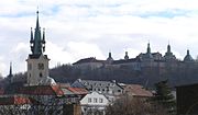
about 21,000 inhabitants. It lies at the confluence of the Berounka and Litavka rivers. Beroun creates a conurbation with Králův Dvůr, former part of Beroun...
13 KB (1,228 words) - 05:29, 18 May 2024

from the Russian Empire and established on the banks of the river, as Litavka, and phonetically reversed to Lithuanian as Lietauka by local Lithuanians...
3 KB (266 words) - 08:56, 13 July 2023

right Mže 105.1 138.9 – Střela 101.7 102.7 left Úslava 96.3 136.0 right Litavka 54.9 34.3 right Klabava 51.2 36.9 right Rakovnický potok 48.5 62.4 left...
7 KB (707 words) - 08:34, 22 December 2023

(highest elevation Písek - 690 m). The main Brdy range starts south of the Litavka river gorge and consists of several major elevations connected into one...
7 KB (963 words) - 11:50, 16 October 2023

Uplands. The highest point is at 435 m (1,427 ft) above sea level. The Litavka River flows through the municipality. The first written mention of Libomyšl...
5 KB (235 words) - 06:54, 8 July 2024

five seasons). The name of the stadium is derived from the name of the Litavka river, located just behind the west stand. The major reconstruction of...
4 KB (329 words) - 04:13, 3 March 2024
590 m (1,940 ft). The town is situated mostly on the right bank of the Litavka River. The Příbramský stream flows through the town and feeds a set of...
33 KB (3,826 words) - 13:22, 3 July 2024
Region of the Czech Republic. It has about 400 inhabitants. It lies on the Litavka river. Moritz Hartmann (1821–1872), poet, politician and author Karel Hartmann...
4 KB (104 words) - 06:39, 18 June 2024

Region of the Czech Republic. It has about 700 inhabitants. It lies on the Litavka river. "Population of Municipalities – 1 January 2024". Czech Statistical...
3 KB (87 words) - 06:04, 8 July 2024

Mže following its confluence with the Radbuza) Loděnice (a.k.a. Kačák) Litavka (in Beroun) Klíčava Rakovnický potok Javornice Střela Třemošná Klabava...
28 KB (1,828 words) - 08:53, 13 July 2024

point is the hill Dubová hora at 627 m (2,057 ft) above sea level. The Litavka River forms the eastern municipal border and separates the municipality...
5 KB (228 words) - 10:01, 24 May 2024

Dvůr, the slopes of the Děd hill at 473 m (1,552 ft) above sea level. The Litavka River flows through the town. Its tributary the Mlýnský Brook supplies...
10 KB (917 words) - 10:09, 20 May 2024

Region of the Czech Republic. It has about 400 inhabitants. It lies on the Litavka river. The first written mention of Čenkov is from 1368. "Population of...
4 KB (105 words) - 06:41, 18 June 2024

Berounka, which drains the entire territory. Its longest tributary is the Litavka. The area is very poor in bodies of water. There are three protected landscape...
11 KB (541 words) - 00:56, 13 July 2024

flows across the district from south to north. Other notable rivers are Litavka and Kocába. The most significant bodies of water are the reservoirs Orlík...
12 KB (672 words) - 00:57, 13 July 2024

former royal mining town. The name literally means "Birch Mountains". The Litavka River partially forms the border with Podlesí. The first evidence of silver...
7 KB (484 words) - 12:45, 23 August 2022

Highlands. The highest point is the hill Leč at 628 m (2,060 ft). The Litavka River flows through the municipality. There are two notable fishponds,...
5 KB (285 words) - 13:47, 24 March 2024

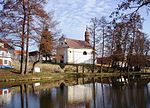
530 ft) above sea level. The built-up area is situated in the valley of the Litavka River. There are several fishponds in the town, supplied by small streams...
8 KB (571 words) - 11:29, 2 July 2024

above sea level. The municipality is situated on the right bank of the Litavka river. The first written mention of Hluboš is from 1355. A wooden fortress...
6 KB (375 words) - 05:34, 24 May 2024
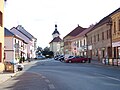
657 ft) above sea level. The town is situated at the confluence of the Litavka River and the stream Červený potok. The first written mention of Zdice...
6 KB (441 words) - 09:02, 13 June 2024