
(2,372 sq mi). The Målselva river passes by the main villages of Bardufoss, Andselv, and Skjold. Store norske leksikon. "Målselva" (in Norwegian). Retrieved...
3 KB (128 words) - 00:12, 17 July 2024
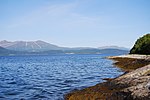
fjords: Nordfjorden, Aursfjorden, Målselvfjorden, and Rossfjorden. The Målselva river feeds into the Målselvfjorden. There are several larger villages...
4 KB (333 words) - 18:15, 28 October 2024

county. The municipality (originally the parish) is named after the river Målselva which flows through the area. The first element is the genitive case of...
39 KB (2,616 words) - 17:45, 8 November 2024

the sea (in the Jøkelfjord). The largest river in Troms (waterflow) is Målselva (in Målselv Municipality), and the largest (not the highest) waterfall...
31 KB (2,868 words) - 02:25, 1 November 2024

located in the Målselvdalen valley near the confluence of the Barduelva and Målselva rivers. It is located about 82 kilometres (51 mi) north of the town of...
11 KB (673 words) - 17:42, 11 September 2024
inhabitants per square kilometre (2,140/sq mi). The village lies along the Målselva river and the European route E6 crosses through the village with the Olsborg...
3 KB (150 words) - 01:34, 17 July 2024
- Altaelva 240 8693 101 Norwegian Sea in Alta Municipality NOR - - 78 Målselva ← Rostaelva 145 6144 171 Norwegian Sea in Målselv Municipality NOR - -...
261 KB (9,219 words) - 22:13, 1 November 2024

which goes the Pasvik valley of the Pasvikelva river. Near the far left corner of the map is the green Målselv valley of Troms, with the Målselva river....
40 KB (4,214 words) - 05:19, 26 October 2024

Norway. It is located on the east side of the village of Skjold along the Målselva river. On 3 November 1996, Holmen was the site of a well documented UFO...
2 KB (128 words) - 00:19, 19 July 2024

Municipality in Troms county, Norway. Skjold is located at the confluence of the Målselva and Fjellfrøselva rivers, about 30 km (19 mi) east of the town of Bardufoss...
3 KB (166 words) - 01:31, 17 July 2024
/ -2.382442; -30.783212 (Rusumo Falls) Målselvfossen [no] 196 22 600 Målselva Norway 69°02′09″N 18°39′16″E / 69.035702°N 18.654563°E / 69.035702;...
45 KB (1,516 words) - 17:06, 19 August 2024

Sweden in the east, through the Dividalen and Rostadalen valleys to the Målselva river and the eastern part of the Målselvdalen valley. The administrative...
15 KB (1,137 words) - 01:05, 29 October 2024

river forming part of the border) before finally emptying into the river Målselva, just outside the village of Bardufoss and the Bardufoss Airport. Barduelva...
3 KB (129 words) - 00:27, 17 July 2024
inland there are extensive pine forests and highlands around the rivers Målselva and Reisaelva. Big islands like Senja, Kvaløya and Ringvassøya have green...
61 KB (6,287 words) - 13:02, 1 November 2024
Målselv Municipality in Troms county, Norway. The area lies along the river Målselva in the Målselvdalen valley in the western part of the municipality. The...
3 KB (152 words) - 02:20, 17 July 2024

the sea (in the Jøkelfjord). The largest river in Troms (waterflow) is Målselva (in Målselv Municipality), and the largest (not the highest) waterfall...
41 KB (3,469 words) - 12:00, 1 November 2024

water discharges to the north into the Barduelva river, which empties into Målselva river, which in turn empties into the Malangen fjord. "Innsjødatabase"...
4 KB (217 words) - 02:34, 19 July 2024
Norway. The village is located about 1 kilometre (0.62 mi) south of the Målselva river and about 21.5 km (13.4 mi) southeast of the urban area of Bardufoss...
3 KB (148 words) - 12:48, 25 August 2024
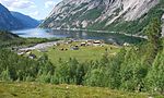
majestic Målselvdalen valley, runs the 140 kilometres (87 mi) long river Målselva, a river renowned for its salmon and trout fishing. The Målselvfoss waterfall...
4 KB (497 words) - 22:52, 17 April 2024
It is part of the Rostaelva river system which empties into the great Målselva river. It is located about 9 kilometres (5.6 mi) east of the village of...
2 KB (89 words) - 08:58, 20 July 2024
county, Norway. The river is located in Målselv Municipality. The river Målselva runs through the valley, ending at the Målselvfjorden (an arm off the main...
2 KB (123 words) - 00:49, 17 July 2024

Målselv Municipality in Troms county, Norway. It is located along the river Målselva at Målselv, about 15 kilometres (9.3 mi) north of the village of Bardufoss...
4 KB (309 words) - 15:41, 20 October 2024

fjord. The same word mál is probably also the origin of the name of the Målselva, the big river that enters the fjord from the Målselvdalen and Bardudalen...
16 KB (1,186 words) - 20:28, 28 October 2024
Målselv Municipality in Troms county, Norway. It is located along the Målselva river about halfway between the villages of Bardufoss and Skjold. It is...
3 KB (119 words) - 07:54, 29 October 2024

northwest it drains into the river Rostaelva, a tributary of the river Målselva, which runs into the Atlantic Ocean. To the southeast it drains into the...
3 KB (205 words) - 18:54, 20 July 2024
Altevatnet empties into the river Barduelva which flows into the river Målselva. "Innsjødatabase". NVE.no (in Norwegian). Retrieved 2024-07-07. "Map of...
3 KB (121 words) - 02:35, 19 July 2024