
Maimay (Dari: مایمی), also known as Darwaz-e Payeen, or simply Darwaz, is a district in Badakhshan Province of Afghanistan. It was created in 2005 from...
4 KB (154 words) - 08:44, 13 August 2023
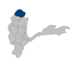
Darwaz District was subdivided into Maimay District, Darwazi Bala District, and Shekay District. Some maps use the name Darwaz for Maimay District. The...
2 KB (127 words) - 22:50, 10 November 2019

Tajikistan.The district borders the Panj River and Tajikistan in the northeast, the Maimay district to the west, the Raghistan district in the southwest...
7 KB (146 words) - 16:35, 24 August 2024
Pitab (category Populated places in Maimay District)
Pitab is a village in Badakhshan Province in north-eastern Afghanistan. Badakhshan Province "Pitab". WorldWeatherOnline.com. Retrieved 2021-09-06. "NGA...
4 KB (47 words) - 22:38, 15 June 2023
Maymey (category Populated places in Maimay District)
Maymey is a village in Badakhshan Province in north-eastern Afghanistan. Badakhshan Province "NGA GeoName Database". National Geospatial-Intelligence Agency...
4 KB (35 words) - 22:35, 15 June 2023
Nesharv (category Populated places in Maimay District)
Nesharv is a village in Badakhshan Province in north-eastern Afghanistan. Badakhshan Province "NGA GeoName Database". National Geospatial-Intelligence...
4 KB (40 words) - 22:37, 15 June 2023

approximately 11,000 residents. This district borders the Shekay, Kuf Ab, and Maimay districts, along with districts in Darvoz, Gorno-Badakhshan Autonomous...
3 KB (174 words) - 17:52, 2 May 2024
Darreh Javay (category Populated places in Maimay District)
38°14′52″N 70°47′37″E / 38.24778°N 70.79361°E / 38.24778; 70.79361 Country Afghanistan Province Badakhshan Province District Maimay Time zone + 4.30...
4 KB (34 words) - 21:46, 15 June 2023
Kawida (category Populated places in Maimay District)
38°19′16″N 71°12′6″E / 38.32111°N 71.20167°E / 38.32111; 71.20167 Country Afghanistan Province Badakhshan Province District Nusay Time zone + 4.30...
4 KB (33 words) - 22:30, 15 June 2023
Madud (category Populated places in Maimay District)
38°6′22″N 70°54′40″E / 38.10611°N 70.91111°E / 38.10611; 70.91111 Country Afghanistan Province Badakhshan Province District Maimay Time zone + 4.30...
4 KB (34 words) - 22:33, 15 June 2023
Khar Kat-e Bala (category Populated places in Maimay District)
38°16′31″N 70°55′46″E / 38.27528°N 70.92944°E / 38.27528; 70.92944 Country Afghanistan Province Badakhshan Province District Maimay Time zone + 4.30...
4 KB (35 words) - 10:21, 5 May 2024
Khevaj (category Populated places in Maimay District)
38°13′28″N 71°0′41″E / 38.22444°N 71.01139°E / 38.22444; 71.01139 Country Afghanistan Province Badakhshan Province District Maimay Time zone + 4.30...
4 KB (33 words) - 22:30, 15 June 2023
Ghonvar (category Populated places in Maimay District)
38°12′41″N 70°46′54″E / 38.21139°N 70.78167°E / 38.21139; 70.78167 Country Afghanistan Province Badakhshan Province District Maimay Time zone + 4.30...
4 KB (33 words) - 22:27, 15 June 2023
Durman, Afghanistan (category Populated places in Maimay District)
38°14′0″N 70°47′0″E / 38.23333°N 70.78333°E / 38.23333; 70.78333 Country Afghanistan Province Badakhshan Province District Maimay Time zone + 4.30...
4 KB (33 words) - 22:23, 15 June 2023
Hojm-e Bala (category Populated places in Maimay District)
38°20′50″N 70°51′55″E / 38.34722°N 70.86528°E / 38.34722; 70.86528 Country Afghanistan Province Badakhshan Province District Maimay Time zone + 4.30...
4 KB (40 words) - 22:28, 15 June 2023
Arun, Badakhshan (category Populated places in Maimay District)
38°18′36″N 70°50′45″E / 38.31000°N 70.84583°E / 38.31000; 70.84583 Country Afghanistan Province Badakhshan Province District Maimay Time zone + 4.30...
4 KB (25 words) - 07:30, 22 January 2021
Hojm-e Pa'in (category Populated places in Maimay District)
38°22′2″N 70°51′16″E / 38.36722°N 70.85444°E / 38.36722; 70.85444 Country Afghanistan Province Badakhshan Province District Maimay Time zone + 4.30...
4 KB (35 words) - 22:28, 15 June 2023
Khughaz (category Populated places in Maimay District)
41917°N 70.84444°E / 38.41917; 70.84444 Country Afghanistan Province Badakhshan Province District Maimay Elevation 4,900 ft (1,500 m) Time zone + 4.30...
4 KB (35 words) - 22:30, 15 June 2023

Vanj District or Nahiya-e Vanj (Tajik: Ноҳияи Ванҷ) is a district in eastern Tajikistan, in the north-west of the Gorno-Badakhshan Autonomous Region, with...
6 KB (250 words) - 00:38, 20 February 2023
(about 255 m above sea level): The area in the northern end of Khamyab District where the Amu Darya flows into Turkmenistan. Afghanistan portal Geography...
6 KB (413 words) - 01:58, 1 September 2024

21,400 residents. This district borders with the Districts Khwahan, Shekay, Nusay, Maimay, Raghistan, and with the Tajik district of Darvoz Gorno-Badakhshan...
4 KB (84 words) - 16:21, 12 February 2024

of Jurm District Khwahan Kishim Kohistan – formerly part of Baharak District Kuf Ab – formerly part of Khwahan District Kuran wa Munjan Maimay – formerly...
175 KB (6,035 words) - 09:30, 31 August 2024

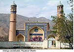
Jamarj-e Bala (category Populated places in Maimay District)
north-eastern Badakhshan Province of Afghanistan, serving as the capital of Maimay District. It is located on the Panj River near the Vanj River. Various spelling...
5 KB (99 words) - 12:23, 7 September 2023
Kuhiston (Persian: کوہستان 'mountainous land'), was the northernmost district of Kapisa Province, Afghanistan. In productive agricultural seasons the...
7 KB (265 words) - 19:04, 14 June 2023
(Persian: شیخعلی) is a district in Parwan province, Afghanistan. The Sheikh Ali district is inhabited by ethnic Hazaras. Districts of Afghanistan Sheikh...
5 KB (27 words) - 07:14, 4 July 2023

2002. The district is within the heartland of the Khogyani tribe of Pashtuns. The district centre is the village of Kaga (or Kazha). District Governor...
8 KB (735 words) - 16:24, 4 June 2024
Chishti Sharif District, also known as Chisht District, is the most easterly district in Herat Province, Afghanistan, situated along the Hari River and...
3 KB (125 words) - 09:14, 28 April 2024
Lashkargah is a district in the east of Helmand Province, Afghanistan, surrounding the provincial capital of Lashkargah. Its population is 99% Pashtun...
3 KB (104 words) - 06:48, 29 June 2023

Wakhan (Persian: واخان) is one of the 28 districts of Badakhshan province in eastern Afghanistan. The district has a border with neighboring Tajikistan...
2 KB (106 words) - 02:18, 23 January 2024

Surobi, Sarobi, or Sarubi District (Pashto: سروبي ولسوالۍ) is a district of Kabul Province, Afghanistan. Its capital, Surobi, lies about 60 kilometres...
7 KB (563 words) - 07:48, 29 December 2021