
Mareeba Shire Hall is a heritage-listed former town hall at 136 Walsh Street, Mareeba, Shire of Mareeba, Queensland, Australia. It was designed by Eddie...
38 KB (4,957 words) - 03:11, 23 December 2023

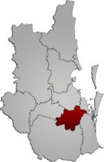
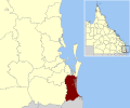
The Shire of Mareeba is a local government area at the base of Cape York Peninsula in Far North Queensland, inland from Cairns. The shire, administered...
21 KB (1,643 words) - 01:31, 22 June 2024

coordinates) GPX (secondary coordinates) Mareeba /məˈriːbə/ is a rural town and locality in the Shire of Mareeba in Far North Queensland, Australia. Between...
35 KB (3,118 words) - 07:19, 9 August 2024

The Mareeba Mosque, officially known as the Mareeba and District Memorial Mosque, is a mosque located in Mareeba, a rural town in Queensland, Australia...
16 KB (1,293 words) - 21:39, 31 July 2024

Irvinebank (category Shire of Mareeba)
(secondary coordinates) Irvinebank is a rural town and locality in the Shire of Mareeba, Queensland, Australia. In the 2021 census, the locality of Irvinebank...
25 KB (2,457 words) - 08:41, 7 July 2024

Chillagoe, Queensland (category Shire of Mareeba)
(secondary coordinates) Chillagoe is a rural town and locality in the Shire of Mareeba, Queensland, Australia. In the 2021 census, the locality of Chillagoe...
19 KB (1,877 words) - 09:07, 13 June 2024

August 2007, the Shire of Eacham merged with the Shires of Atherton, Herberton and Mareeba to form the Tablelands Region. The Shire of Eacham included...
6 KB (498 words) - 12:10, 28 January 2021

Kuranda is a rural town and locality on the Atherton Tableland in the Shire of Mareeba, Queensland, Australia. It is 25 kilometres (16 mi) from Cairns, via...
28 KB (2,875 words) - 05:48, 20 June 2024

glue laminated timber arches for two of his earliest buildings, the Mareeba Shire Hall and Proserpine's St Paul's Church; both were designed in 1956 and...
39 KB (5,239 words) - 18:28, 14 January 2022

Dimbulah, Queensland (category Shire of Mareeba)
the Atherton Tableland. It is within the local government area of Shire of Mareeba (between 2008 and 2013, it was within the Tablelands Region). In the...
22 KB (2,177 words) - 06:28, 7 July 2024

Irvinebank School of Arts Hall is a heritage-listed school of arts at McDonald Street, Irvinebank, Shire of Mareeba, Queensland, Australia. It was built...
11 KB (1,376 words) - 12:59, 22 December 2023

Mount Molloy, Queensland (category Shire of Mareeba)
(secondary coordinates) Mount Molloy is a rural town and locality in the Shire of Mareeba, Queensland, Australia. It is a historic mining and timber town, 55...
11 KB (1,100 words) - 06:30, 9 July 2024

first shire chairman. The Noosa Shire Hall was constructed in Pomona in 1911. On 8 September 1917, an Honour Roll was unveiled at the Noosa Shire Hall in...
37 KB (3,117 words) - 23:52, 25 June 2024

1930) Johnstone Shire Hall at Innisfail (1935-1938) Emergency operating theatre at Boulia (1936) Mossman Shire Hall and Douglas Shire Council Chambers...
3 KB (248 words) - 08:46, 6 November 2022

The Shire of Bulloo (/ˈbʊluː/ BUUL-oo) is a local government area in South West Queensland, Australia. On 17 April 2020 the Queensland Government reorganised...
13 KB (1,004 words) - 23:54, 21 June 2024
Council created the Shire of Albert by amalgamating Shire of Beenleigh, Shire of Coomera, Shire of Nerang, the southern part of Shire of Tingalpa and the...
12 KB (941 words) - 14:48, 26 July 2024

Shire of Paroo is a local government area in South West Queensland, Australia. The administrative centre is the town of Cunnamulla. The Paroo Shire covers...
13 KB (1,008 words) - 02:15, 22 June 2024

joined by the Gillies Highway to Yungaburra, the Kennedy Highway north to Mareeba and south to Ravenshoe and Mount Garnet, the Malanda–Atherton Road to Malanda...
25 KB (2,255 words) - 16:32, 25 July 2024

The Shire of Quilpie is a local government area in South West Queensland, Australia. It covers an area of 67,415 square kilometres (26,029 sq mi), and...
8 KB (545 words) - 01:36, 28 June 2024

The Shire of Hinchinbrook is a local government area in North Queensland, Queensland, Australia. The shire, administered from the town of Ingham, covers...
16 KB (1,042 words) - 01:10, 22 June 2024

Redland City (redirect from Redland Shire, Queensland)
Redland City, also known as the Redlands and formerly known as Redland Shire, is a local government area (LGA) and a part of Greater Brisbane in South...
54 KB (4,260 words) - 22:55, 9 July 2024

Kuranda Fig Tree Avenue (category Shire of Mareeba)
Avenue is a heritage-listed avenue of trees at Coondoo Street, Kuranda, Shire of Mareeba, Queensland, Australia. It was built in 1931. It is also known as Avenue...
27 KB (3,760 words) - 08:08, 25 January 2024
Logan City (redirect from Shire of Logan)
Logan Shire, which included the northern suburbs of both Albert and Beaudesert Shires. A section in the north previously belonged to the Shire of Tingalpa...
45 KB (3,774 words) - 00:37, 24 July 2024

The Shire of Boulia is a local government area in Central West Queensland, bordering the Northern Territory. Its administrative centre is in the town...
8 KB (588 words) - 23:54, 21 June 2024
China since March 24, 1999 Kungur, Perm Krai, Russia since May 30, 2003 Mareeba Shire, Queensland, Australia since November 9, 2004 Jixi, Heilongjiang, China...
12 KB (893 words) - 13:48, 20 July 2024
form since 2008. It is on the border with New South Wales with the Tweed Shire to the south in New South Wales. By the late 1870s, the Government of Queensland...
33 KB (1,760 words) - 01:28, 8 April 2024

Works is a heritage-listed refinery off Jessie Street, Irvinebank, Shire of Mareeba, Queensland, Australia. It was built from 1883 to c. 1908. It is also...
13 KB (1,733 words) - 12:54, 22 December 2023

The Shire of Murweh is a local government area in the Maranoa district, which is part of South West Queensland, Australia. The administrative centre and...
11 KB (974 words) - 09:05, 18 July 2024

School is a heritage-listed state school at High Street, Irvinebank, Shire of Mareeba, Queensland, Australia. It was designed by Robert and John Ferguson...
31 KB (4,215 words) - 23:15, 12 May 2023
Aboriginal Shire of Mapoon Shire of Mornington Aboriginal Shire of Napranum Shire of Mareeba Northern Peninsula Area Region Aboriginal Shire of Pormpuraaw Tablelands...
105 KB (2,694 words) - 04:40, 10 August 2024