
Matthäus Seutter (20 September 1678 Augsburg – March 1757 in Augsburg) was a German map publisher of the 18th century. Seutter started his career as an...
2 KB (275 words) - 15:24, 10 June 2024

Croatian historical regions according to the map of Matthäus Seutter from 1720 Croatia Dalmatia Sclavonia (Slavonia) Istria Ragusina Respublica...
6 KB (481 words) - 06:20, 15 July 2024

Accurata Utopiae Tabula, an "accurate map of Utopia", Johann Baptist Homann's map of Schlaraffenland published by Matthäus Seutter, Augsburg 1730...
14 KB (1,716 words) - 15:09, 16 August 2024
Colby (England, 1784–1852) Matthäus Seutter (Germany, 1678–1757) Friedrich Wilhelm Carl von Schmettau (1743–1806) Matthias Seutter (Germany, 1678–1757) Jacob...
30 KB (3,143 words) - 14:19, 16 June 2024

death of his father. The Duchy of Teschen: 17th/18th century map by Matthäus Seutter The Duchy of Teschen in 1724, by Jonas Nigrinus The Duchy of Teschen...
21 KB (2,064 words) - 13:50, 2 May 2024

New map of the Black Sea Matthäus Seutter 1740 Nova Et Accurata Tartarie Europe Seu Minoris… European Tartary Matthäus Seutter Little Tartary and Ukraine...
16 KB (558 words) - 16:54, 8 August 2024

corner bastions, and four gates with bridges over a wide moat. The Matthäus Seutter map of c. 1735 shows the fortifications had an almost lozenge-shaped...
177 KB (22,261 words) - 21:01, 5 January 2024

A two-part map showing the port of Oran in the 18th century, by German map publisher Matthäus Seutter...
62 KB (5,595 words) - 18:38, 10 August 2024
18th century), master engraver and son-in-law of German map publisher Matthäus Seutter Hans Lotter (1917–2008), highly decorated Oberleutnant in the Luftwaffe...
3 KB (379 words) - 19:02, 28 June 2021

Map of Skåneland by Matthäus Seutter...
129 KB (17,258 words) - 11:49, 25 February 2024

universal display of the naval flags of all nations in the world. London. Matthäus Seutter (1732). Atlas Novus : Algercum munita metropolis Regni Algeriani (in...
58 KB (6,877 words) - 17:42, 20 May 2024

principal ones in Palestine, and was call'd so by the Persians. 1709: Matthäus Seutter, map: Deserta Aegypti, Thebaidis, Arabiae, Syriae etc. ubi accurata...
313 KB (37,857 words) - 19:12, 16 August 2024
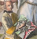
Engelbert Kaempfer Kaempfer depicted in the cartouche of a map of Japan by Matthäus Seutter based on his observations, c. 1730 Born Engelbert Kaempfer (1651-09-16)16...
23 KB (2,713 words) - 05:43, 20 July 2024

but are instead meant to display an idea in a cartographic medium. Matthaus Seutter's The Attack of Love is an example of a battle map used as an allegory...
30 KB (2,828 words) - 21:25, 4 May 2024

Matthäus Seutter: Map of the Bishopric, 1750...
12 KB (1,156 words) - 18:05, 19 June 2024
Paraná.{{cite book}}: CS1 maint: location missing publisher (link) Seutter, Matthäus. "Paraquariae provinciae Soc. Iesu". Bibliotheque Nationale de France...
19 KB (2,438 words) - 17:01, 12 February 2024
Croatian lands in 1720 according to the map of the German cartographer Matthäus Seutter...
8 KB (907 words) - 00:56, 13 February 2023

Planisphaerium Coeleste, original shortly before 1705, copy from 1730 by Matthäus Seutter...
3 KB (351 words) - 06:28, 25 February 2024

ac Cerretaniae comitatuum exactissima dilineatio, cura et studio de Matthäus Seutter", 1740 "Cataloniae principatus, nec non Ruscinonensis et Cerretaniae...
7 KB (707 words) - 23:43, 16 August 2024

based on information from before the Ottoman conquest. For example, Matthäus Seutter's 18th-century map showed the Island and Fabric areas as smaller than...
82 KB (9,763 words) - 15:49, 25 July 2023

p. 43. De Melo Breyner (1895), p. 42. De Barros (1777), p. 157. Seutter, Matthäus (1783), India Orientalis. "Chimay", Encyclopædia Britannica, vol. II...
6 KB (542 words) - 08:41, 23 August 2023

London. Le Rouge, Georges-Louis. (1756). Amerique Meridionale. Paris. Seutter, Matthäus. (1757). Le Pays de Perou et Chili. Augsbourg. Lotter, Tobias Conrad...
80 KB (7,777 words) - 21:44, 3 August 2024