
Mawbanna is a locality and small rural community in the local government area of Circular Head, in the North West region of Tasmania, Australia. It is...
4 KB (255 words) - 17:36, 25 July 2024
The C225 route (Mawbanna Road) intersects with the Bass Highway in the locality, passing through to the south-east on its way to Mawbanna. Fergus Medwin...
4 KB (212 words) - 16:37, 25 July 2024
Marrawah Smithton Stanley Black River Edith Creek Forest Hellyer Irishtown Mawbanna Mengha Redpa Rocky Cape Wiltshire Acton Chasm Creek Cooee Downlands East...
22 KB (787 words) - 08:22, 21 July 2024

The West Coast of Tasmania is one of the regions of Tasmania in Australia. It is mainly isolated rough country and is associated with wilderness, mining...
17 KB (1,861 words) - 18:27, 25 July 2024
Thylacine (category Mammals of Tasmania)
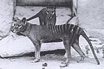
to be killed in the wild was shot in 1930 by Wilf Batty, a farmer from Mawbanna in the state's northwest. The animal, believed to have been a male, had...
111 KB (11,573 words) - 00:48, 20 October 2024

is a list of all bounded localities in Tasmania, Australia, as recognised by the Land Information System Tasmania. The definition of a locality for this...
130 KB (178 words) - 18:10, 14 February 2022
December 2018. "Mengha, Tasmania" (Map). Google Maps. Retrieved 2 December 2018. "Placenames Tasmania - Mengha". Placenames Tasmania. Search, enter 1120D...
3 KB (174 words) - 17:37, 25 July 2024
government area (LGA) of Circular Head in the North-west and west LGA region of Tasmania. The locality is about 35 kilometres (22 mi) east of the town of Smithton...
3 KB (196 words) - 17:11, 25 July 2024
government area (LGA) of Circular Head in the North-west and west LGA region of Tasmania. The locality is about 17 kilometres (11 mi) south of the town of Smithton...
4 KB (199 words) - 17:25, 25 July 2024
Circular Head and Waratah–Wynyard in the North-west and west LGA region of Tasmania. The locality is about 24 kilometres (15 mi) west of the town of Wynyard...
4 KB (190 words) - 17:39, 25 July 2024
government area (LGA) of Circular Head in the North-west and west LGA region of Tasmania. The locality is about 31 kilometres (19 mi) east of the town of Smithton...
3 KB (177 words) - 16:56, 25 July 2024

The Bass Highway is a highway in Tasmania, Australia. It connects the three cities across the north of the state – Burnie, Devonport and Launceston. The...
25 KB (787 words) - 16:34, 25 July 2024
Circular Head Council (category Local government areas of Tasmania)
Circular Head Council is a local government body in Tasmania covering the far north-west mainland. It is classified as a rural local government area with...
10 KB (292 words) - 22:34, 2 March 2024
Road routes in Tasmania assist drivers navigating roads in urban, rural, and scenic areas of the state. The route numbering system is composed of National...
147 KB (1,089 words) - 17:28, 25 July 2024
Tasmania - West Takone". Placenames Tasmania. Search, enter 10551C, Search, select row, show Details. Retrieved 23 April 2020. "West Takone, Tasmania"...
4 KB (200 words) - 18:27, 25 July 2024
Circular Head in the North-west and west LGA region of the island state of Tasmania, Australia. The locality is about 26 kilometres (16 mi) east of the town...
4 KB (223 words) - 16:51, 25 July 2024
government area (LGA) of Circular Head in the North-west and west LGA region of Tasmania. The locality is about 15 kilometres (9.3 mi) east of the town of Smithton...
3 KB (168 words) - 18:09, 25 July 2024
Milabena (redirect from Milabena, Tasmania)
areas of Waratah-Wynyard and Circular Head in the North West region of Tasmania. It is located about 26 kilometres (16 mi) west of the town of Wynyard...
4 KB (263 words) - 17:37, 25 July 2024
the local government area of Circular Head, in the North West region of Tasmania. It is located about 11 kilometres (6.8 mi) east of the town of Smithton...
4 KB (249 words) - 17:02, 25 July 2024
2018. "Rocky Cape, Tasmania" (Map). Google Maps. Retrieved 20 November 2018. "Placenames Tasmania - Rocky Cape". Placenames Tasmania. Search, enter 1213P...
4 KB (214 words) - 18:01, 25 July 2024
Meunna (category Towns in Tasmania)
Circular Head and Waratah–Wynyard in the North-west and west LGA region of Tasmania. The locality is about 74 kilometres (46 mi) south-east of the town of...
4 KB (256 words) - 17:37, 25 July 2024

Dip Falls (category Waterfalls of Tasmania)
cubic-basalt formed rocks on the Dip River, is located in Mawbanna in the North West region of Tasmania, Australia. The waterfall is situated in the Dip Range...
3 KB (146 words) - 17:42, 31 January 2021