
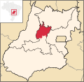
Vale do Rio dos Bois Microregion is a statistical region in central Goiás state, Brazil. It lies west of the state capital, Goiânia. It takes its name...
2 KB (106 words) - 13:34, 11 July 2022

Armação dos Búzios (Portuguese pronunciation: [aʁmɐˈsɐ̃w duz ˈbuzjus]), often referred to as just Búzios, is a municipality located in the state of Rio de...
9 KB (877 words) - 05:16, 9 August 2024

Goiás (redirect from Diocese of Goyaz)
of Goiás dates back to the beginning of the 18th century, with the arrival of pioneers from São Paulo. The Rio Vermelho region was the first to be occupied...
45 KB (3,913 words) - 14:46, 15 August 2024

Anápolis (redirect from History of Anápolis)
Goiás. Anápolis is also the center of the Anápolis Microregion, and belongs to the Goiás Center mesoregion. The climate of the city is tropical savanna (Aw)...
18 KB (1,825 words) - 00:01, 9 August 2024

Colinas do Sul is a municipality in north-central Goiás state, Brazil. Colinas is located in the Chapada dos Veadeiros statistical micro-region and is...
5 KB (412 words) - 18:27, 20 February 2022

of Bonfinópolis, Leopoldo de Bulhões and Silvânia. It is in the Pires do Rio Microregion and has boundaries with Orizona, Pires do Rio, São Miguel do...
5 KB (329 words) - 12:58, 26 October 2021

The Aragarças Microregion is a geographical division in Goiás state, Brazil. It consists of 7 municipalities located around Aragarças in western Goiás...
2 KB (110 words) - 21:28, 25 September 2021

Brazil. It is a large producer of cattle and agricultural products. Quirinópolis is the seat of the Quirinópolis Microregion. It forms boundaries with Gouvelândia...
7 KB (682 words) - 17:35, 31 October 2023

on the Brasília-Salvador highway. Alvorada do Norte is part of the Vão do Paranã Microregion. Neighboring municipalities are Iaciara, Posse, Simolândia...
7 KB (573 words) - 07:30, 8 April 2022

Pires do Rio is a municipality in Goiás state, Brazil. It is a prosperous town and a major producer of poultry. It is located in the Pires do Rio Microregion...
7 KB (658 words) - 18:27, 20 February 2022

the Goiânia Microregion and 17.6%--960,141—of the population lives in the Entorno do Distrito Federal Microregion. The GDP of the state of Goiás was R$50...
4 KB (98 words) - 21:24, 3 January 2020

distance to the north. The territory of the municipality is crossed by the Paranaíba River, the Meia Ponte, the Rio dos Bois and by several small rivers and...
13 KB (853 words) - 14:16, 8 July 2024
São Patrício with 135.0 km2. The microregion consists of the following municipalities: Barro Alto 6,446 Carmo do Rio Verde 8,897 Ceres 18,637 Goianésia...
3 KB (203 words) - 21:27, 25 September 2021

Caldas Novas (section Rio Quente)
Goiânia. It belongs to the Meia Ponte Microregion, which has 338,147 inhabitants (2007) in 21 cities and a total area of 21,229.00 km2. Highway connections...
11 KB (1,165 words) - 05:22, 9 August 2024

Indiara (redirect from History of Indiara)
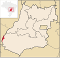
state, Brazil. Indiara is a large producer of soybeans and cotton. Indiara is in the Vale do Rio dos Bois and has municipal boundaries with: north: Palmeiras...
5 KB (377 words) - 03:35, 7 September 2023

north, and Professor Jamil, 32 kilometers to the west. The important Rio dos Bois passes to the west. Municipal boundaries are with: North: Varjão South:...
6 KB (503 words) - 18:27, 20 February 2022

and Canaã dos Carajás to the south. One of Brazil's only inter-city rail services (Carajás Railway) is operated by rail freight operator Vale and links...
8 KB (371 words) - 20:50, 20 April 2024

with the construction of a road linking Goiás and São Miguel do Araguaia. This road was known as the Estrada dos Bois (the highway of the cows). Later a...
5 KB (467 words) - 19:08, 8 September 2023

Miguel do Passa Quatro is a municipality in central Goiás state, Brazil. São Miguel is located in the Pires do Rio Microregion, at a distance of 112 kilometers...
5 KB (367 words) - 18:27, 20 February 2022

producer of sugarcane. Maurilândia is located in the Southwest Goiás Microregion on the Rio São Tomé near the Rio Turvo and the Rio dos Bois, an important...
6 KB (476 words) - 18:27, 20 February 2022
Antônio do Descoberto is a municipality in central Goiás state, Brazil. Santo Antônio do Descoberto is located in the microregion called Entorno do Distrito...
6 KB (453 words) - 04:30, 7 June 2023

municipality in central Goiás state, Brazil. Cezarina belongs to the Vale do Rio dos Bois statistical micro-region. It has municipal boundaries with: north:...
5 KB (384 words) - 18:27, 20 February 2022

Anicuns (section Origin of the name)
situated on the right bank of the Rio dos Bois, the main river in the region and a tributary of the Paranaíba River. The important Rio Turvo also has its source...
7 KB (729 words) - 18:27, 20 February 2022

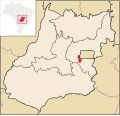
statistical microregion is 014 Vale do Rio dos Bois. As of July 2021,[ref] the Brazilian Institute of Geography and Statistics estimates the population of Varjão...
5 KB (392 words) - 15:42, 1 June 2022
called Santa Rita dos Impossíveis. Later the name was changed to Santa Rita do Araguaia. In 1911 it became a district in the municipality of Mineiros. In 1943...
5 KB (362 words) - 18:27, 20 February 2022

paradise of Goiás" in Portuguese. List of municipalities in Goiás Chapada dos Veadeiros National Park Microregions of Goiás IBGE 2020 "Decree n. 5.419 of 7 May...
15 KB (1,630 words) - 13:49, 20 August 2023

Córrego do Ouro is a municipality in eastern Goiás state, Brazil. Córrego do Ouro is located in the Iporá Microregion west of the state capital, Goiânia...
5 KB (297 words) - 18:27, 20 February 2022
Sudoeste de Goiás Microregion and is 208 km. from the state capital, Goiânia. Connections are made by BR-060 / Guapó / Indiara / Rio Verde / GO-174/ GO-422...
5 KB (415 words) - 14:39, 7 May 2024

micro-region of Vale do Rio dos Bois, southwest of the state capital, Goiânia, on BR-060, (Brasília-Acre) which links Goiânia with Rio Verde. The distance...
6 KB (539 words) - 21:17, 26 August 2022

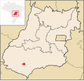
paved road to Cachoeira Dourada, 57 km., and Gouvelândia, 15 km. The Rio dos Bois lies a short distance to the west. The distance to the state capital...
5 KB (359 words) - 18:27, 20 February 2022