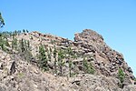
Morro de la Agujereada is the highest elevation of the island of Gran Canaria, Canary Islands, Spain. Located in Pico de las Nieves, it reaches a height...
2 KB (153 words) - 17:37, 28 July 2023
1,560 km2 (600 sq mi) and an altitude of 1,956 m (6,417 ft) at Morro de la Agujereada, Gran Canaria is the third largest island of the archipelago in...
45 KB (4,162 words) - 14:29, 11 November 2024
Pico de las Nieves has been considered the highest peak on the island of Gran Canaria; however, this is uncertain since Morro de la Agujereada stands...
4 KB (456 words) - 20:13, 10 December 2023
point on the island of Gran Canaria, after the Morro de la Agujereada at 1,956 m (6,417 ft), and the Pico de las Nieves at 1,949 m (6,394 ft). It was formed...
3 KB (175 words) - 16:11, 3 June 2024
La Gomera Cuadro sinóptico de los sistemas montañosos españoles, .xls table on www.ine.es "La tecnología destrona al Pico de las Nieves como techo de...
56 KB (90 words) - 15:33, 6 August 2024
Tope de Coroa 1979 m 6493 ft 785 0.125 Cape Verde 77 Cuba (main island) Pico Turquino 1974 m 6476 ft 109884 0.0106 Cuba 78 Gran Canaria Morro de la Agujereada...
79 KB (291 words) - 01:00, 2 November 2024
Roque de los Muchachos on La Palma 2,426 m, Morro de la Agujereada on Gran Canaria 1,956 m, Pico de Malpaso on El Hierro 1,501 m, and Garajonay on La Gomera...
8 KB (638 words) - 21:57, 7 September 2024
level at 1,957.3 meters above sea level at the elevation known as Morro de la Agujereada. The centre of the coast of the municipality is characterised by...
13 KB (1,263 words) - 10:47, 29 January 2024


