Mount Fukushima is, at 2,470 metres (8,100 ft), the highest massif in the Queen Fabiola Mountains of Antarctica, standing just north of Yamato Glacier...
1 KB (148 words) - 20:35, 5 March 2022
prefecture Fukushima, Fukushima, capital city of Fukushima Prefecture, Japan Fukushima University, national university in Japan Fukushima Station (Fukushima) in...
2 KB (203 words) - 09:46, 3 August 2024

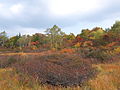
Fukushima Prefecture (/ˌfuːkuːˈʃiːmə/; Japanese: 福島県, romanized: Fukushima-ken, pronounced [ɸɯ̥kɯɕimaꜜkeɴ]) is a prefecture of Japan located in the Tōhoku...
54 KB (3,743 words) - 03:28, 28 September 2024

of the town are in the Fukushima Basin along the Abukuma River, which runs through the southeast of the town. There is Mount Handa (865 meters) is to...
9 KB (491 words) - 11:54, 16 April 2024

Fukushima (福島市, Fukushima-shi, [ɸɯ̥kɯꜜɕima]) is the capital city of Fukushima Prefecture, Japan. It is located in the northern part of the Nakadōri, central...
68 KB (6,201 words) - 14:44, 2 October 2024

Fukushima Daiichi is a multi-reactor nuclear power site in the Fukushima Prefecture of Japan. A nuclear disaster occurred there after a 9.0 magnitude earthquake...
187 KB (19,428 words) - 00:11, 13 September 2024

Mount Azuma-kofuji (吾妻小富士) is an active stratovolcano in Fukushima prefecture, Japan. It has a conical-shaped crater and as the name "Kofuji" (small Mount...
4 KB (295 words) - 21:48, 14 January 2024

Mount Adatara (安達太良山, Adatara-yama) is a stratovolcano in Fukushima Prefecture, Japan. It is located about 15 kilometres southwest of the city of Fukushima...
4 KB (242 words) - 10:34, 8 January 2024

prefectural capital of Fukushima. Mountains Mount Ryōzen (825m) Rivers Uda River Coastal features Matsukawa Lagoon Fukushima Prefecture Minamisōma Iitate...
15 KB (811 words) - 14:25, 17 July 2024

Aizuwakamatsu (redirect from Aizu-Wakamatsu, Fukushima)
the western part of Fukushima Prefecture, in the southeast part of Aizu basin. Mount Iimori Mount Oda Mount Ōtodake (1416 m) Mount Seaburi Aga River Nippashi...
24 KB (1,580 words) - 18:01, 5 October 2024

The Japanese reaction occurred after the Fukushima Daiichi nuclear disaster, following the 2011 Tōhoku earthquake and tsunami. A nuclear emergency was...
146 KB (17,605 words) - 19:29, 1 October 2024

Bandai-Asahi National Park. Mountains : Mount Bandai, Mount Nekomadake Rivers : Nippashi-gawa, Oya-gawa Fukushima Prefecture Kitakata Aizuwakamatsu Inawashiro...
9 KB (451 words) - 08:50, 6 September 2024

region of Fukushima Prefecture, bordered by Yamagata Prefecture to the north and Niigata Prefecture to the west. Mountains: Mount Bandai, Mount Iide Rivers:...
15 KB (773 words) - 08:47, 6 September 2024

Mountains : Mount Bandai Rivers : Nakutsu-gawa, Ono-gawa Lakes : Lake Hibara, Goshiki-numa, Lake Onogawa, Oguni-numa, Akimoto Lake Fukushima Prefecture...
9 KB (443 words) - 11:56, 16 April 2024

Kaneyama (金山町, Kaneyama-machi) is a town located in Fukushima Prefecture, Japan. As of 1 March 2020[update], the town had an estimated population of 1972...
13 KB (544 words) - 19:26, 27 September 2024
surveys. They applied the name Yamato Mountains. The highest massif is Mount Fukushima (2,470 m). The Japanese Antarctic Research Expedition (JARE) found...
3 KB (336 words) - 20:30, 5 March 2022

Located in the southwestern corner of Fukushima prefecture, Hinoemata is surrounded by the mountains Komagatake, Mount Taishaku, and Hiuchigatake (the highest...
12 KB (463 words) - 15:29, 9 August 2024

traditional region consists of six prefectures (ken): Akita, Aomori, Fukushima, Iwate, Miyagi, and Yamagata. Tōhoku retains a reputation as a remote...
18 KB (1,463 words) - 23:38, 25 September 2024

part of the town is mountainous. Mountains : Mount Hakase Rivers : Tadami River, Takitani River Fukushima Prefecture Aizubange Aizumisato Kaneyama Mishima...
9 KB (430 words) - 15:00, 23 September 2024
Belgica Mountains Mount Fukushima 2494 Queen Fabiola Mountains Mount Collard 2492 Belgica Mountains Mount Hoge 2491 Belgica Mountains Mount Dallmann 2485...
9 KB (135 words) - 12:10, 26 September 2023

Miharu Dam Mountains: Mount Adatara (1,728 m), Hiyama (1,054 m), Kohatayama (666.3 m) Rivers: Abukuma River Fukushima Prefecture Fukushima Kōriyama Tamura Motomiya...
16 KB (881 words) - 14:45, 2 October 2024

Goshiki-numa (category Lakes of Fukushima Prefecture)
situated at the foot of Mount Bandai in the center of the lake district of the Bandai Highland (磐梯高原, Bandai-kōgen), Kitashiobara, Fukushima, Japan. Goshiki-numa...
3 KB (232 words) - 16:44, 28 September 2024

composed of mountains and forests. Mountains : Mount Mikunidake (1644 m) Rivers : Aga River Fukushima Prefecture Aizubange Kaneyama Kitakata Yanaizu Niigata...
13 KB (530 words) - 19:25, 27 September 2024
of Fukushima Prefecture, and consists of scattered hamlets along the Nojiri River. Mountains: Mount Hakase [Wikidata] Rivers: Nojiri River Fukushima Prefecture...
8 KB (334 words) - 19:24, 27 September 2024

Fukushima Masanori (福島 正則, 1561 – August 26, 1624) was a Japanese daimyō of the late Sengoku period to early Edo period and served as the lord of the...
17 KB (1,908 words) - 12:49, 12 September 2024

Mount Iide (飯豊山, Iide-san) is the main peak of the Iide mountain range that spans the Fukushima, Niigata and Yamagata prefectures in Japan. On top of...
3 KB (270 words) - 02:36, 28 June 2023

Inawashiro (redirect from Inawashiro, Fukushima)
of Fukushima Prefecture, bordering Yamagata Prefecture to the north and Lake Inawashiro to the south. Mountains : Mount Bandai, Mount Adatara, Mount Azuma-kofuji...
13 KB (553 words) - 22:58, 15 April 2024

is a glacier about 6 miles (10 km) wide, flowing west between Mount Fukushima and Mount Eyskens in the Queen Fabiola Mountains of Antarctica. Discovered...
2 KB (130 words) - 20:06, 5 March 2022

Date (伊達市, Date-shi) is a city in Fukushima Prefecture, Japan. As of 31 May 2020[update], the city had an estimated population of 59,625 in 22,843 households...
23 KB (1,613 words) - 19:11, 4 October 2024

Mount Ryōzen (霊山, Ryōzen) is a mountain on the border of Sōma City and the former town of Ryōzen, in Date City, Fukushima. It is 825 metres (2,707 ft)...
9 KB (812 words) - 18:49, 13 November 2023