
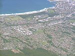
Mount Ousley is a residential suburb situated on the foothills of Mount Keira about four kilometres northwest from the city of Wollongong, New South Wales...
2 KB (82 words) - 14:02, 29 July 2024

Princes Motorway (redirect from Mount Ousley Road)
Yallah. The section between Bulli Tops and Gwynneville was known as Mount Ousley Road, and was first built as a defence route and later upgraded to dual...
33 KB (2,766 words) - 00:31, 9 September 2024

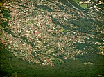
Dapto is a suburb of Wollongong in the Illawarra region of New South Wales, Australia, located on the western side of Lake Illawarra and covering 7.15...
16 KB (1,715 words) - 03:18, 12 August 2024
Shellharbour Village) is a suburb located in the Illawarra region of New South Wales, Australia. It also gives its name to the local government area, City...
8 KB (644 words) - 07:24, 30 July 2024
Mount Ousley Public School is a Kindergarten to grade six primary school, located in Fairy Meadow, New South Wales. The school was established in 1959...
11 KB (809 words) - 02:14, 14 May 2024
School of the Performing Arts. Other nearby primary schools include Mount Ousley Public School and Towradgi Public School. Fairy Meadow is home to University...
8 KB (965 words) - 20:07, 21 July 2024

New South Wales State Heritage Register. Department of Planning & Environment. H01269. Retrieved 18 May 2018. Text is licensed by State of New South Wales...
32 KB (4,111 words) - 10:40, 30 July 2024
Mount Pleasant is a hilly suburb in the city of Wollongong, New South Wales, Australia. It is situated on the northern flank of Mount Keira extending...
3 KB (221 words) - 14:03, 29 July 2024

Mount Warrigal is a large suburb of Shellharbour, New South Wales, Australia. The population, according to the 2021 Australian Census, was 4,880. The...
4 KB (292 words) - 10:49, 23 August 2024
overpass including food stores. North Wollongong is the terminal of Mount Ousley Road, the main route to Sydney. In 1893 Smiths Hill Fort was built to...
4 KB (391 words) - 15:01, 29 July 2024

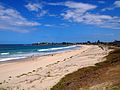
northern suburb of Wollongong, New South Wales, Australia. It is the northernmost point of the Illawarra coastal strip and lies south of Sydney's Royal National...
14 KB (1,618 words) - 07:34, 30 July 2024

Illawarra region of New South Wales, Australia, in the Municipality of Kiama. It has a station (opened 1891) on the NSW TrainLink South Coast Line. The Minnamurra...
4 KB (351 words) - 13:58, 29 July 2024
YOU-nən-derr-ə) is a suburb of Wollongong in New South Wales, Australia. It is located approximately 6 km south-west of the Wollongong CBD. It is bordered...
4 KB (400 words) - 14:47, 30 July 2024

separating it from Dapto, and farmland to the north, west and south. West of Horsley is Mount Bong Bong, part of the Illawarra escarpment range and the Dapto...
3 KB (294 words) - 05:47, 25 May 2024

a suburb north of Wollongong, New South Wales, Australia, south of Sydney. It is served by Woonona Station on the South Coast Line, and by the Princes...
7 KB (1,007 words) - 15:57, 30 July 2024
2019. "Knights Hill (Hill)". Geographical Names Register (GNR) of NSW. Geographical Names Board of New South Wales. Retrieved 29 December 2013. v t e...
2 KB (170 words) - 13:53, 25 January 2024

Wollongong (redirect from Woollongong, New South Wales)
Dharawal: Woolyungah) is a city located in the Illawarra region of New South Wales, Australia. The name is believed to originate from the Dharawal language...
74 KB (7,777 words) - 08:13, 26 September 2024
They treated lead, silver, zinc, copper and gold from Broken Hill, Zeehan, Mount Morgan and Western Australia. "The main plant of the smelting works consisted...
5 KB (666 words) - 12:24, 29 July 2024

local government areas that comprise the Wollongong Metropolitan Area, New South Wales, Australia. Although it is surrounded by a 'green belt' of farms, Albion...
8 KB (849 words) - 09:47, 20 July 2024

Port Kembla is a suburb of Wollongong 10 km south of the CBD and part of the Illawarra region of New South Wales. The suburb comprises a seaport, industrial...
23 KB (2,408 words) - 07:09, 30 July 2024

BULL-eye) is a northern suburb of Wollongong situated on the south coast of New South Wales, Australia. Bulli is possibly derived from an Aboriginal word...
12 KB (1,523 words) - 23:56, 26 August 2024
Warrawong is a suburb of Wollongong in the Illawarra region of New South Wales, Australia. It is situated on the northeast corner of Lake Illawarra. Warrawong...
4 KB (259 words) - 23:42, 22 August 2024

generally fairly mild throughout the year, much like the majority of the New South Wales coast. Day temperatures average between 24 °C and 29 °C in the summer...
13 KB (1,383 words) - 07:30, 8 September 2024
Wollongong, New South Wales, Australia. Balgownie lies to the north-west of the Wollongong CBD. It stretches from the lower slopes of Mount Keira along...
4 KB (275 words) - 10:26, 20 July 2024
established areas and is between the suburbs of Mount Warrigal in the west, Barrack Heights and Barrack Point in the south and Lake Illawarra in the north. Warilla...
4 KB (310 words) - 15:07, 30 July 2024

Mount Keira (/ˈkɪərə/ KEER-ə) is a suburb and mountain in the Illawarra region of New South Wales, Australia. Mount Keira is a site of significant cultural...
32 KB (4,063 words) - 13:59, 29 July 2024

contains a mixture of small rural properties and family homes. It has a New South Wales Rural Fire Service station and a small community hall where the Wongawilli...
3 KB (163 words) - 15:55, 30 July 2024
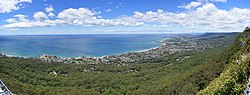
Illawarra escarpment (redirect from Maddens Plains, New South Wales)
high south of Mount Ousley Road (between Keira and Brokers Nose) it reaches 464 metres (1,522 ft) at Mount Keira, 464 metres (1,522 ft) at Mount Warra...
18 KB (1,844 words) - 00:08, 26 September 2024

Condell Park (redirect from Manahan, New South Wales)
Canterbury-Bankstown, is 21 kilometres south-west of the Sydney central business district, in the state of New South Wales, Australia. It is a part of the Canterbury...
8 KB (911 words) - 10:07, 9 August 2024