
Muirs Highway is a Western Australian highway linking Manjimup and Mount Barker, which is on the Albany Highway. It is signed as State Route 102 and is...
4 KB (256 words) - 10:03, 5 October 2024
Places Muir Homes, a privately owned housebuilding company in Scotland Muir Island, a fictional island in the Marvel Comics universe Muirs Highway, Western...
2 KB (269 words) - 19:22, 22 October 2023
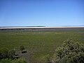
lies near Muirs Highway, north of Walpole and southeast of Manjimup. The lake has a surface area of 46 square kilometres (18 sq mi). Lake Muir and its surrounding...
8 KB (697 words) - 20:05, 29 September 2024

Southern region of Western Australia. The town is located along the Muirs Highway, about 8 kilometres (5 mi) from the Kent River. A site was selected...
2 KB (114 words) - 23:22, 9 January 2024
Lake Muir is a rural locality of the Shire of Manjimup in the South West region of Western Australia. The South Western Highway forms the south-western...
6 KB (520 words) - 04:49, 10 October 2024

along the route, including Coalfields Highway at Arthur River, Great Southern Highway at Cranbrook, and Muirs Highway at Mount Barker. Prior to European...
59 KB (5,492 words) - 12:29, 22 January 2024

University of California, San Diego John Muir High School, an Early College Magnet in Pasadena, California John Muir Highway, a section of California State Route...
104 KB (11,649 words) - 18:22, 1 October 2024
substrates. Muirs Highway passes through the northern end of the reserve, north of Lake Muir. Lake Muir Observatory is located off the highway at the north...
5 KB (453 words) - 13:19, 29 September 2024
crosses the Muirs Highway east of Rocky Gully, flows through Mount Roe and Mount Lindesay national parks, crosses the South Coast Highway near Kenton...
2 KB (202 words) - 07:45, 25 June 2022
on the flower parts. The Lake Muir spider orchid is only known from a small area between Rocky Gully on Muirs Highway and Collie in the Jarrah Forest...
5 KB (530 words) - 07:58, 31 July 2024
Lake Muir National Park is a national park in Western Australia, located 290 kilometres (180 mi) south east of Perth to the south of Muirs Highway in the...
3 KB (175 words) - 11:13, 11 November 2022
The locality's western border is formed by the South Western Highway while the Muir Highway forms its eastern border. A small section of the Sir James Mitchell...
4 KB (234 words) - 07:31, 6 October 2024
south-westerly direction crossing Muirs Highway through Strachan then discharging into the Warren River in Lake Muir Nature Reserve. The Tone River and...
2 KB (144 words) - 10:44, 22 July 2024
permits. Anne Beadell Highway Connie Sue Highway Eagle Highway Gary Highway Gunbarrel Highway Heather Highway Buntine Highway Highway 1 is a route that circumnavigates...
20 KB (702 words) - 02:03, 4 January 2024
as a highway, but without a highway name. For example, Great Southern Highway is classified as a main road, not as a highway, or Hereward Highway in the...
24 KB (399 words) - 08:34, 6 June 2024

Western Highway is a highway in the South West region of Western Australia connecting Perth's southeast with Walpole. It is a part of the Highway 1 network...
27 KB (1,634 words) - 10:12, 7 October 2024
town of Manjimup is 160 kilometres (99 mi) west of Mount Barker, via Muirs Highway. The Hay River, which flows into Wilson Inlet at Denmark, begins its...
26 KB (2,727 words) - 08:00, 5 June 2024

popularity of Muir Woods as a tourist destination has created a great deal of congestion and delay on the two lane California State Highway 1. As a result...
36 KB (4,259 words) - 00:35, 8 October 2024
in Australian Orchid Review, from a specimen collected by Jones near Muirs Highway, 17 km (11 mi) west of the Frankland River crossing in 1985. The specific...
5 KB (528 words) - 11:19, 2 August 2023
Albany Highway Mount Barker Karribank Lodge 10986 Porongurup Langton 10987 Muirs Highway Mount Barker Goundrey Wines Masonic Hall 10988 Muir Street Mount...
14 KB (139 words) - 13:00, 22 February 2023
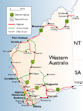
List of road routes in Western Australia (category Highways in rural Western Australia)
composed of National Highways, National Routes, State Routes, and Tourist Drives. Each route has a unique number, except for National Highway 1 and National...
82 KB (1,829 words) - 08:13, 9 October 2024
Shire of Manjimup in the South West region of Western Australia. The Muir Highway forms the western and southern border of the locality. The gazetted townsite...
2 KB (115 words) - 00:00, 6 October 2024
of Western Australia. The locality's southern border is formed by the Muir Highway. The Tone River flows through Mordalup from north to south before turning...
4 KB (258 words) - 07:35, 6 October 2024
northern and eastern borders are formed by the Muir Highway, while it borders the South Western Highway at its far south-western corner. The Warren River...
8 KB (641 words) - 16:02, 8 October 2024

List of major roads in rural Western Australia (redirect from List of freeways, highways, major roads and tracks in rural/remote Western Australia)
Perth. Main Roads Western Australia controls and maintains these roads and highways. Some of these roads, or portions of them, are designated and signposted...
28 KB (310 words) - 01:03, 26 June 2022
millennia. In the 1920s, various local and business groups lobbied for a highway to be constructed over the pass, envisioning it as a scenic route through...
2 KB (225 words) - 04:28, 28 May 2022
Retrieved August 6, 2011. Muir 2011, pp. 233–234. Ankeny, Jason. "Highway to Hell". Allmovie. Retrieved August 6, 2011. Muir 2011, p. 238. Ankeny, Jason...
17 KB (452 words) - 03:51, 9 October 2024
Shire of Manjimup in the South West region of Western Australia. The Muir Highway forms the southern border of the locality while the Perup River runs...
5 KB (407 words) - 15:59, 8 October 2024

in the central business district. Bluewater Highway leaves town and continues along the Grand River to Muir, and the trunkline crosses the Maple River...
30 KB (3,284 words) - 01:10, 5 August 2024

California State Route 1 (redirect from California State Highway 1)
Montana Highway 200. SR 1 has several portions designated as either Pacific Coast Highway (PCH), Cabrillo Highway, Shoreline Highway, or Coast Highway. Its...
137 KB (9,304 words) - 05:27, 5 October 2024