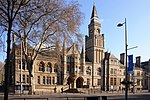
Ealing was a local government district from 1863 to 1965 around the town of Ealing which formed part of the built up area of London until 1965, where it...
6 KB (515 words) - 18:55, 1 November 2023
The London Borough of Ealing (/ˈiːlɪŋ/ ) is a London borough in London, England. It comprises the districts of Acton, Ealing, Greenford, Hanwell, Northolt...
35 KB (2,214 words) - 04:24, 29 June 2024
Ealing (/ˈiːlɪŋ/) is a district in West London, England, 7.5 miles (12.1 km) west of Charing Cross in the London Borough of Ealing. It is the administrative...
51 KB (5,854 words) - 12:30, 23 May 2024

votes ahead of the Conservative candidate, a majority of almost 25% of the votes cast. 1950–1974: The Municipal Borough of Ealing wards of Greenford Central...
41 KB (944 words) - 23:56, 20 July 2024

Ealing London Borough Council, which styles itself Ealing Council, is the local authority for the London Borough of Ealing in Greater London, England....
14 KB (1,034 words) - 08:31, 24 May 2024
Ealing is a suburb of London, England. Ealing can also refer to: Ealing, New Zealand London Borough of Ealing Ealing (electoral division), Greater London...
344 bytes (68 words) - 04:26, 12 October 2023
Ealing West was a constituency, 1945 to 1950 containing parts of the Municipal Borough of Ealing in Middlesex, in west north-west London. It returned one...
4 KB (150 words) - 07:49, 15 July 2024
Ealing South was a constituency covering the same part of the Municipal Borough of Ealing in Middlesex as its short-lived forerunner Ealing East. It returned...
14 KB (440 words) - 20:06, 15 July 2024

Ealing". Victorian Web. Retrieved 30 April 2020. "Ordnance Survey Map". 1875. Retrieved 25 April 2020. "Ealing Town Hall". London Borough of Ealing....
8 KB (790 words) - 22:43, 15 January 2024
Ealing East was one of two and a minority of a third constituency covering the Municipal Borough of Ealing in Middlesex, 1945 – 1950. It included the town...
4 KB (207 words) - 07:49, 15 July 2024

Greenford (category Districts of the London Borough of Ealing)
town in the London Borough of Ealing in west London, England, lying 11 miles (18 km) west from Charing Cross. It has a population of 46,787 inhabitants...
24 KB (2,268 words) - 08:25, 12 May 2024
Greenford High School (category Secondary schools in the London Borough of Ealing)
served the needs of the rapidly growing population of the western edge of the Municipal Borough of Ealing and was provided by Middlesex County Council. It...
7 KB (679 words) - 09:52, 25 August 2023

settlements (minor areas partly in the borough): Acton W3 (South Acton, Gunnersbury) Ealing W5 (South Ealing, Gunnersbury) Hammersmith W6 (Stamford Brook)...
40 KB (3,000 words) - 02:07, 1 July 2024

The coat of arms of the London Borough of Ealing is the official heraldic arms of the London Borough of Ealing, England, granted on 1 September 1965....
2 KB (300 words) - 14:24, 12 July 2023

that of other districts to form the London Borough of Ealing. The oak from the coat of arms is now present in the coat of arms of the London Borough of Ealing...
4 KB (371 words) - 03:50, 17 April 2023
Hospital. The borough was abolished in 1965 by the London Government Act 1963 and its area now forms part of the present-day London Borough of Ealing. Southall...
4 KB (401 words) - 08:35, 17 May 2022
Acton, London (category Districts of the London Borough of Ealing)
and area in west London, England, within the London Borough of Ealing. It is 6.1 miles (10 km) west of Charing Cross. At the 2011 census, its four wards...
35 KB (3,927 words) - 13:49, 21 July 2024

London boroughs – Barnet to the east of ancient Watling Street (now the A5 road), Brent to the southeast, Ealing to the south and Hillingdon to the west...
45 KB (3,358 words) - 10:46, 4 July 2024
The 1964 Ealing Council election took place on 7 May 1964 to elect members of Ealing London Borough Council in London, England. The whole council was up...
40 KB (226 words) - 08:06, 29 January 2024
Greenford Urban District (category History of the London Borough of Ealing)
former area was absorbed by the Municipal Borough of Ealing. Youngs, Frederic (1979). Guide to the Local Administrative Units of England. Vol. I: Southern England...
2 KB (96 words) - 10:35, 23 April 2022
West Twyford (category Areas of London)
northeastern corner of the London Borough of Ealing directly northeast of Hanger Lane station and north of Park Royal, south of the London Borough of Brent and...
11 KB (1,235 words) - 14:43, 22 February 2024

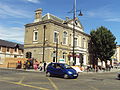
Southall (category Districts of the London Borough of Ealing)
of the London Borough of Ealing and is one of its seven major towns. It is situated 10.7 mi (17.2 km) west of Charing Cross and had a population of 69...
53 KB (5,422 words) - 03:36, 21 July 2024

The London Borough of Ealing, one of the outer London boroughs although not on the periphery, has over 100 parks and open spaces within its boundaries...
11 KB (1,505 words) - 06:50, 16 July 2024

be combined with that of the Municipal Borough of Southgate and the Municipal Borough of Enfield to form the London Borough of Enfield. Edmonton's old...
5 KB (503 words) - 03:50, 17 April 2023

Perivale (category Districts of the London Borough of Ealing)
area of Greater London, 9.5 miles (15.3 km) west of Charing Cross. It is the smallest of the seven towns which make up the London Borough of Ealing. Perivale...
32 KB (2,779 words) - 21:05, 18 April 2024

Acton (UK Parliament constituency) (category History of the London Borough of Ealing)
officer re-classified, the seat as a borough constituency. In 1965 the area became part of the London Borough of Ealing and Greater London. In the redistribution...
27 KB (506 words) - 09:16, 15 July 2024

/ 51.5132; -0.3080 The Victoria Hall, Ealing is a public hall belonging to the west London community of Ealing for their recreational use. It was conceived...
17 KB (1,977 words) - 16:55, 25 April 2024

Chiswick and Perivale and part of that of Hanwell. 1918–1945: The Municipal Borough of Ealing (as it stood in 1918, being Ealing, ignoring 1926 succession...
16 KB (335 words) - 07:48, 15 July 2024

of local government authorities. There were county boroughs, municipal boroughs, urban districts and metropolitan boroughs. The large county boroughs...
27 KB (2,058 words) - 10:47, 30 May 2024

Fox Wood (category Nature reserves in the London Borough of Ealing)
and Site of Borough Importance for Nature Conservation, Grade 1, in Ealing in the London Borough of Ealing. It is owned and managed by Ealing Council....
3 KB (241 words) - 16:20, 27 April 2024