
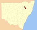
Nandewar (code NAN), an interim Australian bioregion, is located in New South Wales and Queensland, and comprises an area of 2,701,977 hectares (6,676...
5 KB (193 words) - 13:42, 28 May 2022

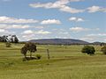
The Nandewar Range, a mountain range that is part of the Great Dividing Range, is located in the North West Slopes region of New South Wales, Australia...
6 KB (531 words) - 00:51, 7 May 2024
(all coordinates) GPX (primary coordinates) GPX (secondary coordinates) Nandewar County is one of the 141 cadastral divisions of New South Wales. It is...
6 KB (109 words) - 06:57, 6 August 2024

List of mountains in Australia (section Nandewar Range)
Grattai Mountain in the Nandewar Range....
80 KB (1,805 words) - 01:52, 20 August 2024

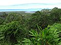
"semi-evergreen vine thickets of the Brigalow Belt (North and South) and Nandewar bioregions", listed under the Commonwealth EPBC Act, and is declining across...
28 KB (2,845 words) - 00:52, 30 August 2024

the volcanic region into the lava terraces, volcanic plugs, and dykes of Nandewar Range. The central feature of the region is Mount Kaputar, the park's namesake...
6 KB (574 words) - 22:14, 18 September 2024
found further inland. It is commonly found at higher altitudes in the Nandewar Range, Liverpool Range and around Orange in the west. It is mostly found...
12 KB (1,310 words) - 07:09, 22 August 2024
is located near Narrabri in northern New South Wales. It is part of the Nandewar Range and has been preserved within the Mount Kaputar National Park. The...
6 KB (514 words) - 00:50, 7 May 2024
Rosa, Sonoma County, California. In Australia, from Warrumbungle volcano, Nandewar volcano, and the Mount Warning complex, New South Wales; and the Peak Range...
5 KB (279 words) - 21:54, 30 January 2024
edge than on its western edge; with the exception of the steeply-rising Nandewar Range which lies in the west of the region. The North West Slopes are situated...
7 KB (646 words) - 14:06, 7 September 2024
Koonyum Range Liverpool Range McPherson Range Moonbi Range Mount Royal Range Nandewar Range Nightcap Range Ramshead Range Snowy Mountains Tweed Range Warrumbungles...
4 KB (331 words) - 00:21, 27 August 2024
within the Nandewar Range, is situated within the North West Slopes region of New South Wales, Australia. The mountain was formed by the Nandewar extinct...
3 KB (211 words) - 06:27, 18 December 2023

Kyeamba Gap Moonbi Range Mount Moonbil Mumbulla Mountain Munghorn Gap Nandewar Range Mount Nardi Tibrogargan Mount Tilga Tinderry Range Mount Ulandra...
56 KB (1,989 words) - 06:17, 5 June 2024
Lofty Block (part) Mulga Lands (part) Murray Darling Depression (part) Nandewar (part) New England Tablelands NSW North Coast NSW South Western Slopes...
27 KB (1,851 words) - 19:39, 5 June 2024

Downs Mount Isa Inlier Mulga Lands Murchison Murray Darling Depression Nandewar Naracoorte Coastal Plain New England Tablelands Northern Kimberley New...
24 KB (2,464 words) - 11:13, 30 August 2024
Dam in the Namoi catchment, plus Pindari Dam on the Severn River. The Nandewar Range is a major western spur of the highlands, culminating in Mount Kaputar...
37 KB (4,233 words) - 02:42, 22 July 2024

Downs Mount Isa Inlier Mulga Lands Murchison Murray Darling Depression Nandewar Naracoorte Coastal Plain New England Tablelands Northern Kimberley New...
23 KB (2,112 words) - 21:18, 13 July 2024

as Castle Rock, Ningadoon (Hunt), and Ningadhun, is a mountain on the Nandewar Range, a spur off the Great Dividing Range, is located in the North West...
2 KB (164 words) - 00:50, 7 May 2024

distribution and is thought confined to the Mount Kaputar region of the Nandewar Range of inland New South Wales. (NSW) Australia. This has resulted in...
3 KB (285 words) - 21:33, 29 May 2024

Lindesay (New South Wales), Australia; is part of the remnants of the Nandewar extinct volcano that ceased activity about 17 Ma after 4 million years...
82 KB (8,453 words) - 17:47, 19 September 2024

Dubbo 172 km (107 mi) NW of Tamworth 101 km (63 mi) S of Moree LGA(s) Narrabri Shire County Nandewar State electorate(s) Barwon Federal division(s) Parkes...
21 KB (1,587 words) - 16:59, 29 June 2024
Semi-evergreen vine thickets of the Brigalow Belt (North and South) and Nandewar Bioregions, endangered. Shale Sandstone Transition Forest of the Sydney...
23 KB (1,451 words) - 18:46, 21 March 2022

Downs Mount Isa Inlier Mulga Lands Murchison Murray Darling Depression Nandewar Naracoorte Coastal Plain New England Tablelands Northern Kimberley New...
17 KB (1,808 words) - 02:58, 10 August 2024
150°00′E / 36.3°S 150.0°E / -36.3; 150.0 (Mount Gulaga) — Mount Kaputar or Nandewar Volcano 1,507 — 30°12′S 150°06′E / 30.2°S 150.1°E / -30.2; 150.1 (Mount...
31 KB (612 words) - 09:07, 8 August 2024

(nandewarica) refers to the Nandewar Range where this species occurs. Mallee red gum grows in mallee shrubland in the Nandewar Ranges, the Warrumbungle Range...
4 KB (386 words) - 17:06, 17 April 2021

(604 m or 1,982 ft) Mid North Coast Banda Banda (1,258 m or 4,127 ft) Nandewar Kaputar (1,489 m or 4,885 ft) Dowe (1,457 m or 4,780 ft) Mount Coryah (1...
37 KB (3,142 words) - 05:09, 10 September 2024

an uncommon species, it grows south of the Hunter Valley, west of the Nandewar Range and Chandler River gorge in rocky situations, mostly near creeks...
3 KB (290 words) - 00:54, 7 May 2023
780 ft) above sea level, Mount Dowe is the second highest mountain in the Nandewar Range, only being just short of Mount Kaputar, at 1,508 metres (4,948 ft)...
3 KB (218 words) - 23:09, 12 December 2021

Australian mulga shrublands Murchison (MUR) Western Australian mulga shrublands Nandewar (NAN) Eastern Australian temperate forests Naracoorte Coastal Plain (NCP)...
13 KB (734 words) - 11:35, 12 August 2024
Downs Mount Isa Inlier Mulga Lands Murchison Murray Darling Depression Nandewar Naracoorte Coastal Plain New England Tablelands Northern Kimberley New...
12 KB (1,137 words) - 23:22, 5 September 2024