
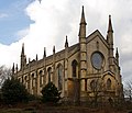
Napton on the Hill is a village and civil parish in the Stratford-on-Avon District of Warwickshire, England. The population of the civil parish taken at...
15 KB (1,878 words) - 23:47, 29 March 2024

Grand Union Canal (redirect from Warwick and Napton Canal)
Grand Union, supported by government grants. The narrow locks (and several bridges) between Napton and Camp Hill Top Lock in Birmingham were rebuilt to take...
33 KB (4,031 words) - 17:39, 21 September 2024

Oxford Canal (category Commons category link is on Wikidata)
the villages of Braunston and Napton-on-the-Hill. The canal is usually divided into the North Oxford Canal (north of Napton, via Rugby to Hawkesbury Junction...
36 KB (3,349 words) - 19:19, 21 September 2024
Monks Kirby, Morton Bagot, Moreton Morrell, Moxhull Napton-on-the-Hill, Nether Whitacre, Newbold-on-Avon, Newbold Pacey, Newnham, Newton, Newton Regis...
9 KB (505 words) - 10:24, 19 February 2024
List of tautological place names (redirect from Lake The Lake)
New Jersey Napton on the Hill, Warwickshire – Napton means "settlement on the hill" Newtownballynoe, County Cork, Ireland—ballynoe from the Irish An Baile...
53 KB (5,941 words) - 00:33, 20 September 2024

Southam (redirect from Market Hill, Southam)
parish in the Stratford-on-Avon district of Warwickshire, England. Southam is situated on the River Stowe, which flows from Napton-on-the-Hill and joins...
26 KB (2,722 words) - 01:27, 29 September 2024
Southam Rural District (category Coordinates on Wikidata)
Compton Gaydon Harbury Hodnell Ladbroke Lighthorne Long Itchington Napton-on-the-Hill Priors Hardwick Priors Marston Radway Ratley and Upton Shotteswell...
2 KB (150 words) - 23:07, 11 April 2023
Hook Norton Brewery (category Commons category link is on Wikidata)
in the east to Worcester in the west and Grove in the south to Napton-on-the-Hill in the north. In total there are 23 Hook Norton pubs in Oxfordshire,...
7 KB (617 words) - 22:06, 4 May 2024
Tom Heap (redirect from The Climate Show)
Tom has presented The Climate Show on Sky News. Tom Heap married Tammany Robin Stone in 1992, and lives in Napton on the Hill near the market town of Southam...
8 KB (540 words) - 16:48, 17 February 2024

Bagot Napton-on-the-Hill, Newbold Pacey, Northend Oldberrow, Oversley Green, Oxhill Pillerton Hersey, Pillerton Priors, Preston Bagot, Preston-on-Stour...
22 KB (1,286 words) - 14:17, 29 September 2024
List of schools in Warwickshire (category Lists of schools in the West Midlands (region))
Joseph's RC Primary School, Whitnash St Lawrence CE Primary School, Napton-on-the-Hill St Margaret's CE Junior School, Whitnash St Marie's RC Primary School...
15 KB (1,495 words) - 17:37, 6 November 2023
which had been built narrow so the locks could accommodate only a single narrowboat. The section between Napton and Camp Hill Top Lock was rebuilt to take...
6 KB (546 words) - 20:40, 26 July 2024
Green Party (UK) (redirect from Green Party of the United Kingdom)
people to form the 'Thirteen Club', so named because it first met on 13 September 1972 at the Napton Bridge pub in Napton-on-the-Hill near Daventry. This...
26 KB (2,530 words) - 08:25, 5 July 2024

Survey of English Dialects (category Languages of the United Kingdom)
Cantlow (Wa5) Hockley Heath (Wa2) Lighthorne (Wa6) Napton on the Hill (Wa4) Nether Whitacre (Wa1) Shipston-on-Stour (Wa7) Stoneleigh (Wa3) Westmorland Great...
33 KB (3,992 words) - 17:11, 31 August 2024

West Midlands (region) (category Coordinates on Wikidata)
Shropshire is now Conservative. The Green Party of England and Wales was formed at the Bridge Inn in Napton-on-the-Hill, Warwickshire, in February 1973...
81 KB (6,367 words) - 16:49, 29 September 2024

Warwickshire (category Pages using the Phonos extension)
The only town in the south of Warwickshire is Shipston-on-Stour. The highest point in the county, at 261 m (856 ft), is Ebrington Hill, again on the border...
53 KB (5,135 words) - 01:35, 29 September 2024

Barby, Northamptonshire (category Coordinates on Wikidata)
south as Napton-on-the-Hill. The nearest wharf was outside Willoughby, about 2 miles (3 km) southwest of Barby. The canal reached Oxford at the end of 1789...
9 KB (832 words) - 12:15, 10 August 2024

Lovelock Cave (category Archaeological sites on the National Register of Historic Places in Nevada)
Heizer and Napton's review of the excavation states “[the guano] was dug up from the upper cave deposits, screened on the hillside outside the cave, and...
20 KB (2,667 words) - 16:34, 24 September 2024

Stockton, Warwickshire (category Coordinates on Wikidata)
walk from the village, was called Napton and Stockton and also served Napton-on-the-Hill about two miles away. The line closed to passengers in 1958 and...
9 KB (1,087 words) - 11:15, 12 September 2024

Willoughby, Warwickshire (category Coordinates on Wikidata)
Construction of the Oxford Canal began north of Coventry in 1769 and was dug through Willoughby parish, reaching Napton-on-the-Hill by 1774. The canal passes...
12 KB (1,342 words) - 00:11, 26 April 2024

2007-10-01 at the Wayback Machine UK Census (2011). "Local Area Report – (E04009628)". Nomis. Office for National Statistics. The Stratford on Avon (Parishes)...
43 KB (2,563 words) - 15:13, 12 September 2023

Kenilworth and Southam (UK Parliament constituency) (category Coordinates on Wikidata)
boundaries: The Borough of Rugby wards of: Dunsmore; Leam Valley. The District of Stratford-on-Avon wards of: Bishop's Itchington, Fenny Compton & Napton; Gaydon...
17 KB (675 words) - 22:23, 20 September 2024

Newbold Pacey (category Coordinates on Wikidata)
south of Warwick, in the Stratford-on-Avon district of Warwickshire, England. The parish includes the hamlet of Ashorne and the parish council is called...
4 KB (262 words) - 04:05, 20 April 2022
June 2009. "NAPTON-ON-THE-HILL". British History Online. Retrieved 17 June 2009. "Introduction: Napton on the Hill. Napton Windmill". Windows on Warwickshire...
29 KB (583 words) - 21:44, 24 July 2022
dating back to 1697, which was never converted into a poor law union under the 1834 Act. Link to 1888 map showing Dorset PLUs; Link to 1909 map showing...
255 KB (984 words) - 17:07, 13 July 2024

Warwickshire ring (category Coordinates on Wikidata)
by the Oxford Canal. At Napton Junction, the Oxford Canal continues straight ahead, but the ring turns to the north, passing Napton Reservoirs on the left...
18 KB (2,404 words) - 22:03, 14 July 2024
List of Royal Observer Corps / United Kingdom Warning and Monitoring Organisation Posts (L–P) (category 1925 establishments in the United Kingdom)
Subterranea Britannica". subbrit.org.uk. "Archived copy". Archived from the original on 23 November 2010. Retrieved 10 November 2010.{{cite web}}: CS1 maint:...
33 KB (247 words) - 21:22, 22 March 2022

Diocese of Coventry (category Coordinates on Wikidata)
East and North. The diocese was formed on 6 September 1918 from part of the Diocese of Worcester. An ancient diocese exists (now called the Diocese of Lichfield)...
20 KB (794 words) - 13:37, 3 September 2024
buildings in the district of Stratford-on-Avon in Warwickshire. The date given is the date used by Historic England as significant for the initial building...
72 KB (111 words) - 14:25, 28 May 2024
This is part of the list of United Kingdom locations: a gazetteer of place names in the United Kingdom showing each place's locality and geographical...
73 KB (26 words) - 20:38, 4 June 2022