Paga Airport/Airstrip (ICAO: DGLN) is an airstrip serving Paga and Navrongo, towns in Kassena-Nankana West District of the Upper East Region of Ghana....
2 KB (95 words) - 17:58, 10 May 2022
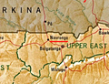
Navrongo is a town and the capital of Kassena-Nankana District in the Upper East Region of northern Ghana, adjacent to the border with Burkina Faso. Navrongo...
13 KB (781 words) - 00:51, 30 May 2024
This is a list of airports in Ghana, sorted by location. Map all coordinates using OpenStreetMap Download coordinates as: KML GPX (all coordinates) GPX...
3 KB (107 words) - 04:55, 11 November 2023
and list. Also see airport category and list. Also see airport category and list. Also see airport category and list. Also see airport category and list...
14 KB (135 words) - 00:23, 7 July 2024

are plans to build a second airport to relieve the aviation pressure on the Kotoka International Airport. This new airport will be located at Prampram...
97 KB (9,215 words) - 04:56, 30 June 2024
District Garu Upper East Region UK Kassena Nankana Municipal District Navrongo Upper East Region UL Kassena Nankana West District Paga Upper East Region...
21 KB (606 words) - 05:39, 30 June 2024

in Sekondi-Takoradi. Takoradi Airport (Sekondi-Takoradi Airport). A house in Takoradi (Sekondi-Takoradi). Takoradi Airport Takoradi Harbour Market Circle...
21 KB (1,408 words) - 03:38, 25 June 2024

Tamale is served by Tamale International Airport. Located about 11 km (6 nmi; 7 mi) from downtown Tamale, the airport is mainly used by commercial airlines...
23 KB (1,455 words) - 08:41, 29 June 2024
served by the Sunyani Airport which is a domestic airport opened on 13 July 1974. However, due to runway length limitations the airport is unsuitable for...
19 KB (1,239 words) - 20:07, 2 June 2024

Hospital Bolgatanga Bolgatanga Municipal Sandema Hospital Sandema Builsa War Memorial Hospital Navrongo Kassena-Nankana Zebilla Hospital Zebilla Bawku West...
35 KB (150 words) - 00:01, 26 February 2024

2016. "Normal Daily Temperature: TEMPERATURE AT V.C. Bird International Airport". Antigua and Barbuda Meteorological Service. Archived from the original...
189 KB (10,521 words) - 00:56, 8 July 2024

l International Airport . As of May 2020, two airlines offered regularly scheduled flights to Accra. Airlines servicing the airport included Africa World...
42 KB (3,415 words) - 05:05, 8 July 2024
culture. Techiman is connected by road to Sunyani and its domestic airport, the Sunyani Airport. Techiman is not yet serviced by a railway station on the Ghana...
15 KB (1,184 words) - 09:01, 2 June 2024
going to Accra, Circle, Nungua, Tema, Lashibi, Klagon, Ashaiman, Spintex, Airport, East Legon, Madina, Accra Mall (Tetteh Quarshie Roundabout) and Lapaz...
6 KB (172 words) - 10:27, 17 October 2023

2013. Wenchi is connected by road to Techiman and Sunyani and its airport, Sunyani Airport. Wenchi is not serviced by a railway station on the Ghana Railway...
6 KB (442 words) - 10:49, 19 June 2024

hour 2 minutes south-west of Kumasi) and Obuasi also has an airstrip and airport. Tourists can visit the town's mine by arranging with the Public Relations...
17 KB (848 words) - 02:08, 10 June 2024

kilometres (22 mi), by road, west of Kotoka International Airport, the International Airport that serves Ghana's capital city of Accra. approximately 28...
25 KB (2,705 words) - 23:05, 17 June 2024

relocated here. Plans are also underway to build the new international airport at a location near Ningo. List of Ghana Parliament constituencies Parliamentary...
5 KB (319 words) - 12:24, 18 May 2022
its end. It is at an elevation of 252 metres. The nearest airport in Ghana is the Tamale Airport in the capital of the Northern Region. Nakpanduri is located...
5 KB (132 words) - 20:43, 14 March 2024
Government and Rural Development. Retrieved 2 June 2021. "Maps, Weather, and Airports for Yagaba, Ghana". www.fallingrain.com. Retrieved 2 June 2021....
5 KB (157 words) - 17:50, 29 January 2023
Councils". ghanadistricts.gov.gh. Retrieved 2 June 2021. "Maps, Weather, and Airports for Asakwa, Ghana". www.fallingrain.com. Retrieved 2 June 2021. v t e...
5 KB (183 words) - 17:29, 29 January 2023