
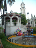
Nochistlán (Spanish pronunciation: [notʃisˈtlan]) is a city in the Mexican state of Zacatecas. Nuño Beltrán de Guzmán, on December 3, 1531, hired Cristóbal...
12 KB (957 words) - 03:56, 6 December 2023

Zacatecas. The Caxcan established Nochistlán by driving out the Tecuexe by force. In the 2020 census, the Municipality of Nochistlán reported a population of 27...
8 KB (415 words) - 18:39, 11 January 2024
Mejía, a secondary educational institution in Quito, Ecuador Tlacotepec de Mejía, a municipality in the state of Veracruz, Mexico Nochistlán de Mejía...
1 KB (214 words) - 20:01, 4 February 2022

Federalismo y el Desarrollo Municipal) (2005). "Nochistlán de Mejía, Zazatecas". Enciclopedia de los Municipios de México (in Spanish) (online edition at E-Local ed...
16 KB (1,855 words) - 21:06, 19 May 2024

Apozol to the north, Nochistlán de Mejía to the east, Moyahua de Estrada to the south, Mezquital del Oro to the southwest, Teúl de González Ortega to the...
20 KB (1,481 words) - 07:20, 19 June 2024

Tlachichila is a small town located in the municipality of Nochistlán de Mejía in the Mexican state of Zacatecas. Mexican Federal Highway 131 runs through...
4 KB (26 words) - 18:07, 2 January 2023
Characteristics of Operation — XHCTAG-TDT RPC: #037964 Shadow XHCTAG, Nochistlán de Mejía, Zac. RPC: Technical Characteristics of Operation - XHCTEN-TDT RPC:...
41 KB (2,843 words) - 16:20, 26 May 2024

is bounded by the municipalities of Jalpa, Juchipila, Nochistlán de Mejía, Tepechitlán and Teúl de González Ortega. The municipality covers a total surface...
6 KB (122 words) - 17:14, 3 December 2023

Guadalajara, the first temporary site of which was at Tenamaztle’s home of Nochistlán, Zacatecas. The Spaniards encountered increased resistance as they moved...
11 KB (1,465 words) - 07:05, 5 May 2024

Sanguino, Julieta (2023-10-12). "¿Día de la Raza o Día de la Resistencia indígena? Preguntas para conmemorar el 12 de octubre". El País México (in Mexican...
85 KB (9,086 words) - 05:39, 7 June 2024

El Plateado de Joaquín Amaro, Huanusco, Jalpa, Juchipila, Mezquital del Oro, Momax, Monte Escobedo, Moyahua de Estrada, Nochistlán de Mejía, Susticacan...
8 KB (420 words) - 23:30, 24 July 2024
the state of Zacatecas and it is bounded by the municipality of Nochistlán de Mejía. The municipality covers a total surface area of 200 square kilometers...
6 KB (125 words) - 17:15, 3 December 2023

Colegio de Michoacán [es], El Colegio de San Luis [es]. p. 565. ISBN 970-679-031-4. Retrieved 21 June 2021. Estado de Zacatecas. División Territorial de 1810...
14 KB (805 words) - 21:15, 24 March 2024

de los Municipios y Delegaciones de México (in Spanish). INAFED. Retrieved 16 June 2021. "Morelos". Enciclopedia de los Municipios y Delegaciones de México...
26 KB (750 words) - 15:42, 16 July 2024
municipalities of Trinidad García de la Cadena to the west, Teúl de González Ortega to the north, Juchipila to the northeast, and Moyahua de Estrada to the east. It...
14 KB (828 words) - 23:56, 4 December 2023

Enciclopedia de los Municipios y Delegaciones de México (in Spanish). INAFED. Retrieved 23 January 2021. Estado de Zacatecas. División Territorial de 1810 a...
11 KB (754 words) - 23:56, 4 December 2023

Noria de Ángeles to the south, Ojocaliente to the southwest, and General Pánfilo Natera to the northwest. It also borders the municipalities of Villa de Ramos...
15 KB (958 words) - 15:52, 21 January 2024

Melchor Ocampo is situated in the drainage basin of the Laguna de Viesca [es] in the Bolsón de Mapimí. Melchor Ocampo's climate ranges from semiarid to arid...
10 KB (700 words) - 23:55, 4 December 2023
Trinidad García de la Cadena is a municipality in the Mexican state of Zacatecas, located approximately 200 kilometres (120 mi) southwest of Zacatecas...
15 KB (954 words) - 17:40, 15 January 2024

Noria de Ángeles is a municipality in the Mexican state of Zacatecas, located approximately 75 kilometres (47 mi) southeast of the state capital of Zacatecas...
15 KB (984 words) - 17:58, 12 March 2024

Salado. The highest point of the municipality is Cerro San Gil in the Sierra de Zacatecas southeast of the town of Hacienda Nueva, with an elevation of 2...
11 KB (785 words) - 22:42, 15 May 2024

Santa María de la Paz is a municipality in the Mexican state of Zacatecas, located approximately 165 kilometres (103 mi) southwest of the state capital...
11 KB (766 words) - 05:16, 6 December 2023

San Nicolas mines in Sombrerete, Villa Hidalgo in Santa Rita and Nochistlán de Mejía and La Palmita in Nieves. In late 1829 he unsuccessfully attempted...
7 KB (836 words) - 17:54, 5 June 2024
the east. It also borders the municipalities of Rincón de Romos to the southeast and San José de Gracia to the south, which are both in the state of Aguascalientes...
14 KB (851 words) - 10:11, 24 May 2024
registro de candidaturas a cargos de elección popular de los partidos políticos y coaliciones" (PDF) (in Spanish). Instituto Electoral del Estado de Zacatecas...
14 KB (814 words) - 13:05, 26 August 2023

municipal de desarrollo Susticacán, 2014-206" (PDF). H. Ayuntamiento de Susticacán. Retrieved 27 April 2015. Estado de Zacatecas. División Territorial de 1810...
17 KB (1,121 words) - 13:48, 9 January 2024

Enciclopedia de los Municipios y Delegaciones de México (in Spanish). INAFED. Retrieved 22 January 2021. Inventario físico de recursos minerales de la carta...
14 KB (773 words) - 10:29, 24 March 2024
and Guadalupe to the northwest. It also borders the municipality of Villa de Ramos in the state of San Luis Potosí to the northeast. The municipality covers...
10 KB (709 words) - 02:09, 25 May 2024

the northeast, Noria de Ángeles to the east, and Loreto to the southeast. It also borders the municipalities of Cosío, Rincón de Romos, and Tepezalá in...
14 KB (838 words) - 02:18, 16 May 2024
unserved by other radio stations. Instituto Federal de Telecomunicaciones. Infraestructura de Estaciones de Radio FM. Last modified 2018-05-16. Retrieved July...
6 KB (80 words) - 16:03, 27 July 2024