8195 inhabitants in Nocupétaro. There are 142 localities in the municipality, of which only the municipal seat Nocupétaro de Morelos is classified as urban...
10 KB (677 words) - 07:24, 10 February 2024
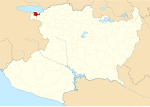
state capital of Morelia. The municipal seat is at Villa Morelos. The municipality of Morelos is located in the Trans-Mexican Volcanic Belt in northern...
9 KB (585 words) - 21:59, 16 September 2024

originally incorporated as Valladolid, changing its name on September 12, 1828. Morelos was originally incorporated as Huango, changing its name on May 5, 1902...
40 KB (681 words) - 16:07, 5 January 2025

de Morelos San Lucas Lombardia Nueva Italia Apatzingan Aguililla Tingambato Tuzantla Susupuato de Guerrero Nocupétaro Carácuaro Tiquicheo Huetamo de Nuñez...
3 KB (148 words) - 19:08, 15 September 2024
Cojumatlán de Régules is a municipality in the Mexican state of Michoacán. It is located 180 kilometres (110 mi) west of the state capital of Morelia....
10 KB (693 words) - 06:35, 9 February 2024

000 and 2,900 metres (6,600–9,500 ft). It borders the municipalities of Morelos to the north, Chucándiro to the east, Morelia to the south, Coeneo to the...
13 KB (720 words) - 14:43, 23 August 2024

Enciclopedia de los Municipios y Delegaciones de México (in Spanish). INAFED. Retrieved 9 January 2021. Estado de Michoacán de Ocampo. División Territorial de 1810...
11 KB (774 words) - 03:41, 28 February 2022

(Villa Morelos) Múgica (Nueva Italia) Nahuatzen (Nahuatzen) Nocupétaro (Nocupétaro de Morelos) Nuevo Parangaricutiro (Nuevo San Juan Parangaricutiro) Nuevo...
2 KB (87 words) - 11:30, 8 February 2024
política de Michoacán 2018-2021". Alcaldes de México (in Spanish). Retrieved 9 January 2021. "Resumen municipal: Municipio de Tanhuato". Catálogo de Localidades...
14 KB (738 words) - 15:57, 10 February 2024
200–8,200 ft). It borders the municipalities of Puruándiro to the north, Morelos to the northeast, Huaniqueo to the east, Coeneo to the southeast, Zacapu...
14 KB (748 words) - 09:25, 9 November 2024

Churintzio, Michoacán de Ocampo" (in Spanish). INEGI. Retrieved 24 April 2018. Estado de Michoacán de Ocampo. División Territorial de 1810 a 1995 (PDF) (in...
10 KB (547 words) - 23:57, 6 June 2024
400 and 1,600 metres (1,300–5,200 ft). It borders the municipalities of Nocupétaro to the west, Madero to the north, Tiquicheo to the east, Huetamo to the...
11 KB (761 words) - 13:40, 18 November 2023
Villa de Jiménez. A man named Patrocinio Aguilar lived there and supplied travellers with provisions, so that the place became known as Vado de Aguilar...
9 KB (323 words) - 02:59, 10 January 2025

"Lienzo de Nahuatzen". INAH. Retrieved 27 December 2020. Roskamp, Hans (2004). "El Lienzo de Nahuatzen: origen y territorio de una comunidad de la Sierra...
13 KB (994 words) - 07:23, 10 February 2024

política de Michoacán 2018-2021". Alcaldes de México (in Spanish). Retrieved 26 December 2020. "Resumen municipal: Municipio de Indaparapeo". Catálogo de Localidades...
13 KB (653 words) - 15:33, 4 September 2024

elevation between 2,100 and 3,400 metres (6,900–11,200 ft) in the Sierra de Mil Cumbres mountain range in northeastern Michoacán. It borders the Michoacanese...
13 KB (710 words) - 14:36, 10 February 2024

sociodemográfico de Michoacán de Ocampo 2015 (PDF) (in Spanish). INEGI. 2016. p. 68. ISBN 978-607-739-850-9. "Consulta de Códigos Postales". Catálogo Nacional de Códigos...
14 KB (742 words) - 06:29, 18 March 2024

Almonte was born in the town of Nocupétaro in the state of Michoacán, the out-of-wedlock son of José María Morelos, a Roman Catholic priest who led the...
24 KB (2,808 words) - 09:20, 20 January 2025

visa program. The story registers Hernando de Bascones, Lorenzo Sánchez de Ulloa, Juan García de Cueva, Diego de Castro Guzmán and Fernando Bocanegra, as...
8 KB (425 words) - 04:50, 19 January 2025
well as the municipalities of Amealco de Bonfil in Querétaro to the northeast, and Temascalcingo and El Oro de Hidalgo of the State of Mexico to the east...
13 KB (691 words) - 04:23, 13 January 2025

the Carácuaro River. The southeastern corner of Insurgente José María Morelos National Park [es] extends into Tzitzio near its municipal seat. Tzitzio's...
13 KB (677 words) - 03:41, 28 February 2022

composed of 11 municipalities: Ario, Carácuaro, Churumuco, Huetamo, Madero, Nocupétaro, San Lucas, Tacámbaro, Tiquicheo, Tumbiscatío and Turicato. The INE deems...
18 KB (1,070 words) - 23:25, 6 January 2025