Ojos de Maricunga is a volcano in the Maricunga Belt of Chile (Mpodozis et al. 1995, p. 278), in the Cordillera Domeyko.(Muñoz 1894, p. 51) Ojos de Maricunga...
7 KB (880 words) - 15:26, 9 March 2024

Ficha de Solicitud Declaración Zona de Interés Turístico (ZOIT) "Salar de Maricunga Ojos del Salado" (PDF) (Report) (in Spanish). Subsecretaría de Turismo...
83 KB (9,588 words) - 21:17, 11 September 2024
Pastillitos, the volcanoes Cadillal, Jotabeche Norte, La Laguna, Ojos de Maricunga, Santa Rosa and Villalobos were formed. The volcano has been degraded...
4 KB (428 words) - 15:26, 9 March 2024

Nevado Tres Cruces National Park (redirect from Nevado de Tres Cruces National Park)
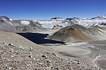
of the Salar de Maricunga. The park is divided into two zones, the northern zone encompassing the southern portion of Salar de Maricunga and Laguna Santa...
5 KB (374 words) - 06:24, 15 August 2024
Southern Andean Volcano Observatory (Spanish: Observatorio Volcanológico de los Andes del Sur; OVDAS) because of their critical activity or proximity...
39 KB (596 words) - 12:01, 17 January 2024
15.0 ± 0.3 million years ago has been obtained on one lava flow. Ojos de Maricunga "Cerro Doña Inés". GEOnet Names Server. Kay et al. 1994, p. 1085....
8 KB (777 words) - 15:24, 9 March 2024
Jotabeche (category CS1 German-language sources (de))
long Maricunga belt. Some stratovolcanoes in the belt include Copiapó-Azufre, Cerros Bravos, Doña Inés, La Laguna, Lagunillas, Ojos del Maricunga, Santa...
21 KB (2,489 words) - 19:20, 27 November 2023

Copiapó (volcano) (redirect from Volcan de Copiapo)
which Nevado Tres Cruces National Park is divided. In its vicinity lies Ojos del Salado. At its summit an Inca platform can be found. Dacitic volcanism...
7 KB (570 words) - 09:03, 10 May 2023

Incahuasi (redirect from Cerro de Incahuasi)
have been recorded, such as an eruption at Ojos del Salado in 1993. Incahuasi is located northeast of Ojos del Salado, the highest volcano in the world...
22 KB (2,314 words) - 05:48, 15 August 2024
Wheelwright caldera (category CS1 German-language sources (de))
confines. It lies in the Andes of the Atacama Region, east of the Salar de Maricunga. The caldera lies just southwest of the Chile-Argentina border, which...
15 KB (1,838 words) - 15:22, 9 March 2024

Los Patos (redirect from Cerro de Los Patos)
At that time, volcanic activity in the Maricunga Belt had just ended and was shifting towards the area of Ojos del Salado and Nevado Tres Cruces. Another...
5 KB (478 words) - 23:04, 6 December 2023

Nevado Tres Cruces (category CS1 German-language sources (de))
Chile (Atacama Region) and Argentina (Catamarca Province). The Salar de Maricunga is located west of Nevado Tres Cruces, the Almagro valley north and its...
34 KB (3,678 words) - 16:23, 25 June 2024

Cerro Blanco (volcano) (redirect from Campo de Piedra Pómez)
and are poorly studied. During the Neogene, volcanism commenced in the Maricunga belt and eventually shifted to its present-day location in the Western...
81 KB (9,278 words) - 11:41, 15 August 2024
Incapillo (category CS1 German-language sources (de))
volcanism in the CVZ. After activity in the volcanic arc of the western Maricunga Belt ceased six million years ago, volcanism commenced in the Incapillo...
35 KB (3,976 words) - 06:07, 14 June 2024

San Francisco Pass (redirect from Paso de San Francisco)
Copiapó with the Chilean–Argentine border. On the way it passes next to Maricunga's salt flat on the Nevado Tres Cruces National Park and Laguna Verde. The...
3 KB (246 words) - 09:47, 6 February 2023