
The Okeechobee Waterway or Okeechobee Canal is a relatively shallow artificial waterway in the United States, stretching across Florida from Fort Myers...
13 KB (919 words) - 04:15, 28 May 2024
Florida, United States Okeechobee Waterway, in Florida, United States Okeechobee Plain, in Florida, United States Okeechobee Group, geologic group in...
514 bytes (87 words) - 11:41, 16 April 2020

miles of levees to protect areas surrounding Lake Okeechobee from overflow. The Okeechobee Waterway was officially opened on March 23, 1937, by a procession...
43 KB (5,074 words) - 04:45, 10 July 2024

Caloosahatchee River (category Lake Okeechobee)
Everglades, east of Fort Myers. An important link in the Okeechobee Waterway, a manmade inland waterway system of southern Florida, the river forms a tidal...
10 KB (883 words) - 00:36, 18 May 2024

Harmful algal bloom (section Okeechobee Waterway)
Lake Okeechobee is an ideal habitat for cyanobacteria because its shallow, sunny, and laden with nutrients from Florida's agriculture. The Okeechobee Waterway...
162 KB (18,138 words) - 19:01, 7 June 2024

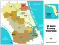
of boats, the St. Lucie Canal is now the eastern segment of the Okeechobee Waterway. The C-44 has been a source of contention since its construction...
9 KB (770 words) - 02:02, 14 March 2023

Intracoastal Waterway Okeechobee Waterway Point Pleasant Canal Lewes and Rehoboth Canal Inland waterways of the United States Waterways forming and crossings...
24 KB (2,505 words) - 17:38, 21 May 2024
Atlantic Ocean. The entire river is accessible to Lake Okeechobee by the Okeechobee Waterway. The main river passes through Sewall's Point, Port Salerno...
19 KB (1,693 words) - 06:38, 1 April 2024

The Okeechobee hurricane of 1928, also known as the San Felipe Segundo hurricane, was one of the deadliest hurricanes in the recorded history of the North...
70 KB (7,943 words) - 04:41, 2 July 2024
The following movable bridges (drawbridges and swing bridges) exist in the U.S. state of Florida. Bridge of Lions, SR A1A over Matanzas River (AIWW), St...
15 KB (1,147 words) - 02:48, 2 March 2024
Pacific Ocean. Lake Okeechobee in Florida is a particularly rare example of a trifurcation lake. Via the artificial Okeechobee Waterway, it flows east to...
7 KB (835 words) - 16:07, 24 February 2024

exports. The Intracoastal Waterway follows the Indian River as it passes through the Treasure Coast. The Okeechobee Waterway connects Stuart with Ft. Myers...
18 KB (1,773 words) - 20:37, 1 July 2024

in the United States: This list includes active canals and artificial waterways that are maintained for use by boats. Although some abandoned canals and...
32 KB (701 words) - 21:04, 4 April 2024

Everglades Intracoastal Waterway Indian River Lagoon List of Florida rivers List of major springs in Florida Okeechobee Waterway Okefenokee Swamp Outstanding...
7 KB (677 words) - 19:29, 13 September 2023

incorporates 71% of the lagoon's surface. Lake Okeechobee is connected to the lagoon by the Okeechobee Waterway and the St. Lucie River meeting in Sewall's...
25 KB (2,583 words) - 14:31, 6 May 2024

Port Mayaca, Florida (category Populated places on Lake Okeechobee)
of Lake Okeechobee. Named for the Mayaca Tribe, Port Mayaca is centered just south of the Port Mayaca Lock and Dams on the Okeechobee Waterway (St. Lucie...
5 KB (447 words) - 09:11, 8 June 2024

A. Loftin (May 31, 2017). "Cyanobacteria of the 2016 Lake Okeechobee and Okeechobee Waterway harmful algal bloom". USGS.org.{{cite journal}}: CS1 maint:...
5 KB (587 words) - 16:11, 13 March 2023

Florida Heartland (category Okeechobee County, Florida)
the Okeechobee Waterway is a navigable canal which crosses the region, connecting the Gulf of Mexico to the Atlantic Ocean through Lake Okeechobee. There...
14 KB (1,095 words) - 05:51, 19 May 2024

Lake Harbor, Florida (category Populated places on Lake Okeechobee)
Harbor, however, is directly on the Okeechobee Waterway, enabling connections to multiple other regions of Lake Okeechobee and its maritime links. Commercial...
14 KB (1,310 words) - 05:29, 9 July 2024
River Water Management District Port Mayaca Lock and Dam, on the Okeechobee Waterway, USACE Rodman Dam, Rodman Reservoir, Florida Department of Environmental...
2 KB (241 words) - 03:21, 21 September 2023
and Maryland, United States (Assawoman Canal) Southern Florida (Okeechobee Waterway) Southeastern New Jersey (Delaware and Raritan Canal) Part of North...
30 KB (1,912 words) - 18:07, 17 June 2024
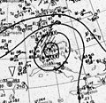
The effects of the 1928 Okeechobee hurricane in Florida included at least 2,500 fatalities in the state, making this the second deadliest tropical cyclone...
128 KB (15,098 words) - 04:42, 2 July 2024

The Port Mayaca Lock is a navigable lock and dam on the Okeechobee Waterway (St. Lucie Canal), adjacent to U.S. Route 441 and U.S. Route 98 at Canal Point...
5 KB (459 words) - 05:18, 9 March 2024

Herbert Hoover Dike (category Buildings and structures in Okeechobee County, Florida)
south of the Brighton Seminole Indian Reservation "Lake Okeechobee and The Okeechobee Waterway". U.S. Army Corps of Engineers South Florida Operations...
9 KB (1,108 words) - 03:14, 22 January 2023
Florida State Road 704 (redirect from Okeechobee Boulevard)
State Road 704 (SR 704), also known as Okeechobee Boulevard, is a 10.199-mile-long (16.414 km) east–west boulevard in the West Palm Beach area, known for...
10 KB (738 words) - 16:55, 16 February 2024

Florida State Road 710 (category State Roads in Okeechobee County, Florida)
northwest-southeast route connecting SR 70 near Okeechobee, three miles (5 km) from the northern tip of Lake Okeechobee in south central Florida, to Old Dixie...
7 KB (407 words) - 18:17, 20 June 2024
the Royal Poinciana Hotel, The Breakers, and Whitehall. In 1928, the Okeechobee hurricane struck Palm Beach County and caused thousands of deaths. More...
114 KB (9,073 words) - 18:41, 2 July 2024

Great Loop (category Intracoastal Waterway)
system of waterways that encompasses the eastern portion of the United States and part of Canada. It is made up of both natural and man-made waterways, including...
8 KB (973 words) - 14:09, 6 June 2024

Herbert Hoover Dike around Lake Okeechobee altered and disrupted the natural flow. Today the Barley Barber waterway is diverted through the L-65 canal...
9 KB (1,042 words) - 00:00, 5 September 2021
Florida is part of the Intracoastal Waterway, a 3,000 mile (4,800 km) inland waterway. Florida has the Okeechobee Waterway, St. Lucie Canal (C-44), Miami Canal...
23 KB (2,009 words) - 03:32, 3 January 2024