Ouray County /ˈjʊəreɪ/ is a county located in the U.S. state of Colorado. As of the 2020 census, the population was 4,874. The county seat is Ouray. Because...
21 KB (1,840 words) - 18:18, 26 July 2024

Ouray (/ˈjʊəreɪ/ YOOR-ay) is a home rule municipality that is the county seat of Ouray County, Colorado, United States. The city population was 898 as...
28 KB (2,229 words) - 10:37, 26 August 2024
Ouray may refer to: Ouray County, Colorado Ouray, Colorado, a small city Ouray Peak, Colorado Mount Ouray, Colorado Ouray, Utah, a village Ouray National...
435 bytes (79 words) - 08:34, 24 December 2020
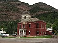
The Ouray County Courthouse, constructed in 1888, is the seat of government of Ouray County, Colorado. It is located at the corner of 6th Avenue and 4th...
2 KB (97 words) - 02:00, 8 August 2023
San Miguel County. Originally the San Miguel County portion was to retain the name Ouray County with the new portion called Uncompahgre County. Mining operators...
14 KB (779 words) - 11:25, 3 May 2024

National Register of Historic Places listings in Colorado (redirect from National Register of Historic Places listings in Ouray County, Colorado)
Historic Places. They are distributed over 63 of Colorado's 64 counties; only the City and County of Broomfield currently has none. This National...
67 KB (735 words) - 20:39, 10 August 2024

Portland is a census-designated place (CDP) located in and governed by Ouray County, Colorado, United States. The CDP is a part of the Montrose, CO Micropolitan...
6 KB (167 words) - 18:22, 17 July 2024

Ouray (/ˈjʊəreɪ/, c. 1833 – August 20, 1880) was a Native American chief of the Tabeguache (Uncompahgre) band of the Ute tribe, then located in western...
23 KB (2,875 words) - 16:35, 2 August 2024

List of high schools in Colorado (section Ouray County)
Junior Senior High School, Rocky Ford Swink High School, Swink Ouray High School, Ouray Ridgway High School, Ridgway Platte Canyon High School, Bailey...
39 KB (2,315 words) - 20:01, 8 June 2024
January 1877, Routt and Ouray were formed, followed by Gunnison and Custer counties in March. In February 1879, Chaffee County was created. From February...
63 KB (2,279 words) - 13:47, 10 August 2024
A List of Communities in Ouray County. Cimarron Mesa - A Log Hill Mesa residential community on the northern slopes of the mesa. Dallas Meadows - A community...
2 KB (275 words) - 20:29, 15 August 2020

Box Canyon (Colorado) (category Landforms of Ouray County, Colorado)
is a box canyon in Ouray County, Colorado, United States. A mining camp was established in the canyon that helped the city of Ouray establish itself as...
3 KB (292 words) - 15:23, 19 June 2024
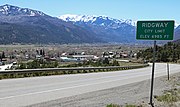
Ridgway, Colorado (category Towns in Ouray County, Colorado)
the home rule municipality that is the most populous municipality in Ouray County, Colorado, United States. The town is a former railroad stop on the Uncompahgre...
28 KB (2,495 words) - 06:08, 14 August 2024
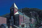
The Ouray County Plaindealer is a weekly newspaper based in Ouray County, Colorado, United States, and owned by 550 Publishing, Inc. It is the newspaper...
7 KB (671 words) - 00:51, 2 August 2024
Colorado topography.) The courtroom scenes were filmed at Ouray County Courthouse in Ouray. The scenes that take place at the "dugout" and along the creek...
30 KB (3,476 words) - 07:54, 27 August 2024
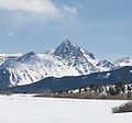
Mount Sneffels (category Mountains of Ouray County, Colorado)
256°) of the City of Ouray in Ouray County, Colorado, United States. The summit of Mount Sneffels is the highest point in Ouray County. Mount Sneffels is...
6 KB (458 words) - 04:52, 27 July 2023

The Uintah and Ouray Indian Reservation (/juːˈɪntə/, /ˈjʊəreɪ/) is located in northeastern Utah, United States. It is the homeland of the Ute Indian Tribe...
12 KB (1,268 words) - 20:19, 25 April 2024
Yankee Boy Basin (category Landforms of Ouray County, Colorado)
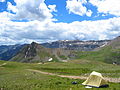
Yankee Boy Basin is an alpine basin in Ouray County, southwestern Colorado. It is in the San Juan Mountains, protected within Uncompahgre National Forest...
2 KB (206 words) - 02:38, 4 July 2021

San Juan Mountains (category Mountain ranges of Ouray County, Colorado)
consolidated the power of thirty-six mining properties in San Miguel, Ouray, and San Juan counties. The SJDMA refused to consider any reduction in hours or increase...
13 KB (929 words) - 04:55, 27 August 2024

Imogene Pass (category Landforms of Ouray County, Colorado)
southwest part of the US state of Colorado. It crosses a ridge connecting Ouray, Colorado with Telluride, Colorado, and is the highest mountain pass in...
3 KB (253 words) - 20:52, 5 June 2023

first to do so without carrying Ouray County since William Howard Taft in 1908. At the same time, Trump flipped five counties in the state: Conejos, Chaffee...
68 KB (2,354 words) - 00:02, 1 September 2024

as Arapahoe County, Jefferson County, Larimer County, and Ouray County. This is also the only presidential election that Broomfield County, created in...
49 KB (1,418 words) - 23:58, 23 August 2024

western Colorado in the United States, about five miles (8.0 km) south of Ouray. The mountains get their name from the reddish iron ore rocks that cover...
6 KB (418 words) - 03:24, 29 November 2022
Twin Peaks (disambiguation) (redirect from Twin Peaks (Salt Lake County, Utah))
County, Colorado), in the Sawatch Range Twin Peaks (Ouray County, Colorado), in the Sneffels Range Twin Peaks (Sangre de Cristo), in Alamosa County Twin...
3 KB (376 words) - 20:44, 4 August 2024

Red Mountain Pass (San Juan Mountains) (category Landforms of Ouray County, Colorado)
the United States. The pass straddles a divide that separates Ouray and San Juan counties. The pass is named for the nearby Red Mountain on the northeast...
8 KB (414 words) - 00:11, 16 April 2024

Hinsdale County with Ouray County, in Colorado, United States. Engineer Mountain is situated 5.7 miles southeast of the community of Ouray on land administered...
5 KB (454 words) - 23:34, 3 July 2023
populous county in Colorado, while Hinsdale County with a 2023 population of 765 is now the least populous county. Five of the 64 Colorado counties have more...
29 KB (373 words) - 21:14, 9 July 2024
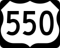
U.S. Route 550 (category Transportation in Ouray County, Colorado)
Montrose, Colorado in the western United States. The section from Silverton to Ouray is frequently called the Million Dollar Highway. It is one of the roads...
17 KB (1,287 words) - 07:59, 23 July 2024

Uncompahgre River (category Rivers of Ouray County, Colorado)
Juan County, in the Uncompahgre National Forest in the northwestern San Juan Mountains is the headwaters of the river. It flows northwest past Ouray, Ridgway...
7 KB (523 words) - 16:07, 9 July 2024

again until 1992. Arapahoe County, Jefferson County and Ouray County would not vote Democratic again until 2008, and Chaffee County would not vote Democratic...
47 KB (286 words) - 07:30, 29 August 2024