Ouray Peak, elevation 12,963 ft (3,951 m), is a summit in the Sawatch Mountains of Colorado. The peak is 6 mi (9.7 km) south of Independence Pass in the...
2 KB (180 words) - 07:18, 22 December 2021
Ouray may refer to: Ouray County, Colorado Ouray, Colorado, a small city Ouray Peak, Colorado Mount Ouray, Colorado Ouray, Utah, a village Ouray National...
435 bytes (79 words) - 08:34, 24 December 2020

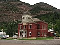
Ouray (/ˈjʊəreɪ/ YOOR-ay) is a home rule municipality that is the county seat of Ouray County, Colorado, United States. The city population was 898 as...
28 KB (2,223 words) - 11:53, 12 September 2024

Ouray (/ˈjʊəreɪ/, c. 1833 – August 20, 1880) was a Native American chief of the Tabeguache (Uncompahgre) band of the Ute tribe, then located in western...
24 KB (2,928 words) - 21:52, 23 September 2024
Ouray County (/ˈjʊəreɪ/) is a county located in the U.S. state of Colorado. As of the 2020 Census, the population was 4,874. The county seat is Ouray...
21 KB (1,820 words) - 19:47, 2 October 2024

Sawatch Range (section Prominent peaks)
of the twenty highest peaks in the Rocky Mountains, including Mount Elbert, at 14,440 feet (4,401 m) elevation, the highest peak in the Rockies. The range...
13 KB (490 words) - 09:25, 26 July 2024

northwest of the peak. The mountain is named after the Ute Chief Ouray. Nearby Chipeta Mountain, just over a mile to the northwest of Mount Ouray, is named after...
6 KB (458 words) - 01:09, 8 March 2024
032' Otis Peak 12,486' Ouray Peak 12,963' Pacific Peak 13,957' Pagoda Mountain 13,497' Paiute Peak 13,088' Palmyra Peak 13,319' Parika Peak 12,402' Park...
140 KB (11,208 words) - 08:35, 3 October 2024

and abandoned mines that place the area in historical context. Below the peak, the surrounding hills are high desert, covered in sagebrush. Among the sagebrush...
6 KB (499 words) - 11:09, 11 July 2024

previously released in August 2008 from a private herd on the nearby Uintah and Ouray Indian Reservation. This herd is approximately 100 miles (160 km) north...
4 KB (362 words) - 00:33, 22 March 2024

Roan Cliffs initially pass through the southern edge of the Uintah and Ouray Indian Reservation. The cliffs continue their southeast course along the...
10 KB (1,073 words) - 11:54, 8 August 2024

feet (805 m) above North Fork Lake Creek in one mile (1.6 km). The highest peak in Colorado, Mount Elbert, is 5.59 miles (9.00 km) to the northeast of Star...
4 KB (295 words) - 23:51, 22 July 2024

Elk Mountains (Colorado) (section Prominent peaks)
Snowmass Mountain (14,092 ft), Pyramid Peak (14,018 ft), and North Maroon Peak (14,014 ft). Maroon Peak and North Maroon Peak are collectively known as the Maroon...
15 KB (586 words) - 16:41, 22 May 2024

includes 30 peaks with more than 500 meters of topographic prominence but less than 4267 meters in elevation: Grizzly Peak, Mount Ouray, Vermilion Peak, Mount...
58 KB (6,673 words) - 20:46, 18 March 2024

Imogene Pass (category Landforms of Ouray County, Colorado)
southwest part of the US state of Colorado. It crosses a ridge connecting Ouray, Colorado with Telluride, Colorado, and is the highest mountain pass in...
3 KB (253 words) - 20:52, 5 June 2023

Rabbit Ears Range (section Highest peaks)
east from the Park Range to the north. Rabbit Ears Pass and Rabbit Ears Peak, despite their names, are not in the Rabbit Ears Range, but actually part...
3 KB (173 words) - 21:35, 2 January 2023

southeastern Ouray County, approximately 9 miles (14 km) east of the town of Ouray and 2.75 mi (4.4 km) west of Uncompahgre Peak. Wetterhorn Peak and neighboring...
5 KB (371 words) - 14:15, 26 July 2023
Matterhorn Peak Menefee Peak Middle Peak Mount Oso Mount Wilson Niagara Peak Red Mountain (Ouray County) Redcloud Peak Rio Grande Pyramid San Luis Peak Sharkstooth...
2 KB (34 words) - 17:41, 7 October 2022

settlers. Nearby Mount Ouray, just 1.9 miles (3.1 km) southeast of Chipeta Mountain, is named after Chipeta's husband, Chief Ouray. Chipeta Mountain is...
10 KB (977 words) - 03:08, 1 July 2024
Twin Peaks is a 10,970-foot-elevation (3,340-meter) double summit mountain located in Ouray County, Colorado, United States. Twin Peaks is situated one...
4 KB (318 words) - 06:27, 24 August 2023

Fairview Peak is mountain summit in the Sawatch Range of the Rocky Mountains of North America. The 13,214 feet (4,028 m) mountain is located in Gunnison...
8 KB (832 words) - 15:06, 26 June 2024

Chicago Peak is a 13,385-foot-elevation (4,080-meter) mountain summit located on the shared boundary of San Miguel County with Ouray County in southwest...
5 KB (381 words) - 17:03, 29 June 2023

Ute people (section Uinta and Ouray Indian Reservation)
live in Utah and Colorado, within three Ute tribal reservations: Uintah-Ouray in northeastern Utah (3,500 members); Southern Ute in Colorado (1,500 members);...
70 KB (7,586 words) - 00:08, 26 August 2024

Matterhorn Peak Menefee Peak Middle Peak Mount Oso Mount Wilson Niagara Peak Red Mountain (Ouray County) Redcloud Peak Rio Grande Pyramid San Luis Peak Sharkstooth...
6 KB (596 words) - 10:30, 5 August 2024

Two Buttes is a dual-peaked mountain in Prowers County, Colorado. The two peaks, which are the highest point in Prowers County, rise about 300 feet (91 m)...
3 KB (173 words) - 12:56, 5 March 2024

Matterhorn Peak Menefee Peak Middle Peak Mount Oso Mount Wilson Niagara Peak Red Mountain (Ouray County) Redcloud Peak Rio Grande Pyramid San Luis Peak Sharkstooth...
3 KB (231 words) - 02:38, 30 October 2020
971 m). Several other peaks in the range are over 9,000 feet (2,743 m), but these elevations stand in contrast to the higher peaks of the Front Range to...
5 KB (396 words) - 05:19, 3 August 2024

Byers Peak, elevation 12,799 ft (3,901 m), is a mountain in Grand County, Colorado southwest of Fraser, Colorado. The mountain is part of the Byers Peak Wilderness...
3 KB (137 words) - 19:27, 10 September 2023
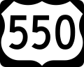
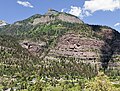
U.S. Route 550 (category Transportation in Ouray County, Colorado)
Montrose, Colorado in the western United States. The section from Silverton to Ouray is frequently called the Million Dollar Highway. It is one of the roads...
17 KB (1,287 words) - 07:59, 23 July 2024

Moctezuma II of Mexico. Montezuma Montezuma Creek Ouray County - named Ute chief Ouray City of Ouray Mount Ouray Saguache County – name comes from the Ute language...
11 KB (991 words) - 04:10, 11 January 2024