
Payette Peak, at 10,221 feet (3,115 m) above sea level is a peak in the Sawtooth Range of Idaho. The peak is located in the Sawtooth Wilderness of Sawtooth...
2 KB (132 words) - 12:36, 19 July 2024
Payette may refer to: Payette, Idaho Payette County, Idaho Payette Lake, a natural lake in southwestern Idaho Payette National Forest, Idaho Payette Peak...
966 bytes (143 words) - 08:19, 16 June 2021

Utah List of mountains in Utah List of mountains of Idaho List of mountain peaks of Idaho List of mountain ranges in Idaho "Bear River Mountains". Peakbagger...
3 KB (177 words) - 14:19, 22 January 2024

North Raker Packrat Peak Parks Peak (Blaine County) Payette Peak Sevy Peak Snowyside Peak Thompson Peak Warbonnet Peak Williams Peak (Custer County) Smoky...
3 KB (146 words) - 23:24, 30 July 2024

using a class 2 route (scramble) from the access road to neighboring Sawtell Peak. The south and west slopes of Mount Jefferson drain into Hell Roaring Creek...
3 KB (242 words) - 09:46, 23 December 2021
of the peaks and climbing destinations in Idaho's Sawtooth Range. Idaho portal Mountains portal List of mountains of Idaho List of mountain peaks of Idaho...
24 KB (97 words) - 02:36, 21 July 2024
Glassford Peak, at 11,602 feet (3,536 m) above sea level is the third highest peak in the Boulder Mountains of Idaho. Located in the Hemingway–Boulders...
2 KB (153 words) - 22:43, 3 July 2023

encompass 885 square miles (2,292 km2) and its two highest peaks are the 8,282-foot (2,524 m) Grave Peak and the 7,424-foot (2,263 m) McConnell Mountain. The...
3 KB (238 words) - 17:34, 28 July 2024

is Thompson Peak at 10,751 feet (3,277 m), on its eastern border in the Sawtooth Wilderness. The county's lowest point is on the Payette River, on its...
27 KB (2,368 words) - 23:08, 18 August 2024
facilities Seattle City Light - a brief history Bureau of Reclamation - major storage reservoirs in the Boise & Payette River basins - current levels & flows...
7 KB (450 words) - 21:10, 10 February 2024

Precipitation runoff from the mountain's slopes drains to the South Fork Payette River via Baron and Goat creeks. Topographic relief is significant as the...
4 KB (290 words) - 15:16, 18 July 2024

the western United States, primarily in southwestern Idaho, where the Payette, Boise, Weiser, Malheur, and Owyhee rivers drain into the Snake River....
7 KB (759 words) - 03:11, 23 April 2024

Precipitation runoff from the mountain's slopes drains to the South Fork Payette River via Baron and Goat creeks. Topographic relief is significant as the...
5 KB (320 words) - 03:44, 29 June 2024

Pike National Forest (redirect from Pike's Peak National Forest)
Range of Colorado, United States, west of Colorado Springs including Pikes Peak. The forest encompasses 1,106,604 acres (4,478 km2) within Clear Creek, Teller...
13 KB (578 words) - 12:12, 1 October 2024

Salmon NF are considered separately, the Payette NF (33.45%) becomes the largest component. Jim McClure–Jerry Peak Wilderness (most is managed by Salmon–Challis...
7 KB (494 words) - 11:26, 1 October 2024

Bighorn National Forest (redirect from Cloud Peak Wilderness Area)
lowlands at the foot of the mountains, to 13,189 feet (4,020 m) on top of Cloud Peak, the highest point in the Bighorn Mountains. Around 99% of the land is above...
17 KB (873 words) - 10:24, 1 October 2024

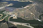
The Payette National Forest is a U.S. National Forest located in central western Idaho, in parts of Valley, Idaho, Adams, and Washington counties. The...
5 KB (476 words) - 12:13, 1 October 2024

headwater (near Vernon Lake, ID) to mouth (Payette River, ID) Dams are listed in order from headwater (near Illinois Peak, ID/MT) to mouth (Clearwater River,...
145 KB (5,874 words) - 04:41, 7 June 2024

Largest in Idaho Little Redfish Lake Lucky Peak Lake Moyie River North Fork Clearwater River Pack River Payette Lake, (McCall) Pettit Lake Priest Lake Perkins...
105 KB (8,415 words) - 00:52, 24 September 2024

portion of the Wallowa–Whitman National Forest and on the south by the Payette National Forest. The mountains in this forest provide wildlife habitat...
6 KB (523 words) - 12:27, 1 October 2024

Sawtooth Range (Idaho) (section Peaks)
the main stem of the Salmon River and the west side by the South Fork Payette River. Small portions of the northern and southern ends of the range are...
10 KB (930 words) - 22:59, 10 May 2024

Frank Church–River of No Return Wilderness (category Payette National Forest)
components than any other wilderness. In descending order of acreage they are: Payette National Forest (33.45%) Challis National Forest (21.78%) Salmon National...
17 KB (1,546 words) - 23:04, 29 April 2024
McArthur Lake Montour Montpelier Mud Lake Niagara Springs Payette River Pend Oreille Portneuf Red River St. Maries Sand Creek Snow Peak Sterling Tex Creek...
15 KB (1,533 words) - 13:24, 8 July 2024

Arcadia Publishing Incorporated. p. PT9. ISBN 978-1-61423-903-1. Phil Payette; Pete Payette. "Colorado forts - Fort Huerfano". American Forts Network. Retrieved...
15 KB (633 words) - 21:40, 24 June 2024
United States. It is nestled along the north bank of the South Fork of the Payette River in the central part of the state, at an elevation of 3,800 feet (1...
7 KB (681 words) - 22:32, 19 July 2024

Largest in Idaho Little Redfish Lake Lucky Peak Lake Moyie River North Fork Clearwater River Pack River Payette Lake, (McCall) Pettit Lake Priest Lake Perkins...
35 KB (1,734 words) - 17:22, 3 September 2024
2008, Canadian media reported that former Radio-Canada host Dominique Payette filed a lawsuit against the White Stripes for using a nine-second clip...
19 KB (1,509 words) - 16:55, 26 September 2024

length. Tree is hardy, and a regular bearer. Eating Use December–June Payette Idaho Selected 1936. Introduced 1944. A red apple. P Ben Davis x Wagener...
527 KB (2,989 words) - 01:26, 26 September 2024
needed] Chief Eagle Eye Creek (formerly Squaw Creek), a tributary of the Payette River in western Idaho, United States Ioway Creek (Ames, Iowa), formerly...
2 KB (318 words) - 19:03, 11 March 2023
singer Julie Owono (born c. 1987), French and Cameroonian lawyer Julie Payette (born 1963), Canadian astronaut and engineer Julie Powell (1973–2022),...
15 KB (1,669 words) - 19:41, 25 September 2024