
related to Pferdskopf (Taunus). OpenStreetMap. "link" (in German). Retrieved 2017-11-15. Municipality Schmitten. "View from the Pferdskopf-Tower" (in...
2 KB (112 words) - 22:48, 26 January 2022

(825 m) and Altkönig (798 m). The Taunus range spans the districts of Hochtaunuskreis, Main-Taunus-Kreis, Rheingau-Taunus, Limburg-Weilburg, and Rhein-Lahn...
25 KB (3,178 words) - 20:08, 18 June 2024

Hintertaunus. In the Taunus Nature Park, it rises directly south of Haintchen, a district of the municipality of Selters (Taunus). The Eisenbach stream...
1 KB (145 words) - 04:26, 22 July 2024

The Taunus Nature Park (German: Naturpark Taunus) (until December 2012 called the High Taunus Nature Park or Naturpark Hochtaunus) is a nature park in...
8 KB (714 words) - 17:43, 7 August 2023
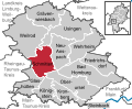
Taunus (until 25 August 2021 Schmitten) is a municipality in the Hochtaunuskreis in Hessen, Germany. Schmitten is the highest community in the Taunus...
9 KB (941 words) - 08:22, 19 April 2024
the Weil Valley in Hesse, Germany. Weilrod lies north of the crest of the Taunus, from 210 to 600 m above sea level. The nearest bigger towns are Limburg...
6 KB (561 words) - 19:36, 4 November 2023

Taunus Gackerstein (663 m), Vogelsbergkreis, Vogelsberg Pferdskopf (662.6 m), Hochtaunuskreis, Taunus Weißeberg (660.2 m), Hochtaunuskreis, Taunus Hohes...
48 KB (3,820 words) - 16:56, 22 January 2024

mountains and hills of the Taunus contains a selection of the highest and most notable mountains and hills in the Taunus and its foothills in the German...
80 KB (412 words) - 19:13, 16 March 2024

Hochtaunuskreis Pferdskopf (662.6 m), Hochtaunuskreis Kalte Herberge (619.3 m), Rheingau-Taunus-Kreis Hohe Wurzel (617.9 m), Rheingau-Taunus-Kreis Hohe Kanzel...
29 KB (2,178 words) - 18:33, 20 March 2022