Region, Castilla Province, Chachas District. Pillune lies southeast of a lake named Machucocha. escale.minedu.gob.pe - UGEL map of the Castilla Province...
2 KB (127 words) - 22:15, 15 April 2022

(17,480 ft) high. It lies in the Arequipa Region, Castilla Province, Chachas District. Chila Pillune is situated west of Chila, the highest mountain of...
2 KB (144 words) - 05:23, 15 April 2022
located in the Arequipa Region, Castilla Province, Chachas District. Ticlla lies southwest of Chila and Chila Pillune at a valley named Puncuhuaico (possibly...
3 KB (165 words) - 03:14, 31 December 2019
It is situated in the Arequipa Region, Castilla Province, Chachas District. Ancocala lies southwest of Pillune and the lake named Machucocha. "Cerro Ancocala"...
2 KB (120 words) - 17:58, 12 June 2020
located in the Arequipa Region, Castilla Province, Chachas District. Yuaytacondorsenja lies northwest of Chila and Chila Pillune. It is situated at the end...
2 KB (126 words) - 02:04, 16 April 2022
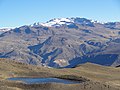
widest point. Machucocha lies southeast of Huajrahuire and northwest of Pillune. Teofilo Laime Acopa, Diccionario Bilingüe, Iskay simipi yuyay k'ancha...
2 KB (102 words) - 09:30, 9 March 2024
lies in the Arequipa Region, Castilla Province, Chachas District. It is situated southwest of Chila, northeast of Chila Pillune and southeast of Yuaytacondorsenja...
2 KB (209 words) - 05:20, 15 April 2022
Chinchón, 5,400 m (17,700 ft) Choquepirhua, 5,400 m (17,700 ft) Chila Pillune, 5,400 m (17,700 ft) Chuañuma, 5,400 m (17,700 ft) Quiscapampa, 5,400 m...
5 KB (417 words) - 08:13, 25 December 2023