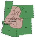
fault-separated plateaus: Awapa Plateau Aquarius Plateau Kaiparowits Plateau Markagunt Plateau Paunsaugunt Plateau Sevier Plateau Fishlake Plateau Pavant Plateau Gunnison...
34 KB (4,109 words) - 10:47, 17 June 2024

Bryce Canyon National Park (category Colorado Plateau)
collection of giant natural amphitheaters along the eastern side of the Paunsaugunt Plateau. Bryce is distinctive due to geological structures called hoodoos...
36 KB (3,389 words) - 04:12, 14 June 2024
Geology of the Bryce Canyon area (category Colorado Plateau)
east–west direction. Two of these faults bound the Paunsaugunt Plateau; the Sevier on the west and the Paunsaugunt on the east. Movement along these two faults...
26 KB (3,332 words) - 15:13, 14 October 2023
characterize the Markagunt, Paunsaugunt, and Aquarius Plateaus. Boulder Mountain, one of the largest high-elevation plateaus in the United States, is dotted...
8 KB (674 words) - 00:53, 23 April 2024

on the east border of Kolob Terrace; the forested Markagunt and Paunsaugunt Plateaus border northwest, and northeast. East is a mountain region water...
13 KB (759 words) - 15:49, 5 April 2023

Grand Staircase–Escalante National Monument (category Colorado Plateau)
568 km2) in 2021. The western part of the monument is dominated by the Paunsaugunt Plateau and the Paria River, and is adjacent to Bryce Canyon National Park...
27 KB (2,669 words) - 03:59, 8 July 2024

Garfield County from several creeks that descend from the edge of the Paunsaugunt Plateau, meeting just north of Tropic. It flows SSE across Kane County and...
9 KB (737 words) - 14:13, 25 April 2024

Imhof, Eduard, “Die Anordnung der Namen in der Karte,” Annuaire International de Cartographie II, Orell-Füssli Verlag, Zürich, 93-129, 1962. English Translation:...
28 KB (3,703 words) - 13:55, 6 March 2024
genetically distant and declining population at southern Utah's Paunsaugunt Plateau. Recovery program involvement: 1995 – Present Contribution to the...
56 KB (6,436 words) - 15:37, 5 July 2024

center is currently home to 20 toads that were collected from Utah's Paunsaugunt Plateau. Theses toads have been carefully bred so that their disease-free...
122 KB (17,039 words) - 23:25, 12 July 2024
elevation of 7,310 ft (2,230 m) between the Markagunt Plateau (on the west) and the Paunsaugunt Plateau.: 82 The river flows north through a wide valley...
52 KB (5,938 words) - 04:27, 22 April 2024
436 m) 21 Bryce Canyon UT0621 Rainbow Point [1][permanent dead link] Paunsaugunt Plateau 9,115 feet (2,778 m) Yellow Creek 6,565 feet (2,001 m) 2,550 feet...
34 KB (984 words) - 18:27, 10 March 2024
Cretaceous Mammals from Bryce Canyon National Park and Vicinity, Paunsaugunt Plateau, Southwestern Utah". In Alan L. Titus; Mark A. Loewen (eds.). At...
80 KB (4,582 words) - 02:47, 8 July 2024

Cretaceous stratigraphy and vertebrate faunas of the Markagunt, Paunsaugunt, and Kaiparowits plateaus, southern Utah". Geology of the Intermountain West. 3: 229–291...
69 KB (7,936 words) - 12:05, 13 July 2024