
Portolan charts are nautical charts, first made in the 13th century in the Mediterranean basin and later expanded to include other regions. The word portolan...
19 KB (2,309 words) - 12:29, 24 August 2024
Claude Portolan (born 16 December 1960) is a French former international rugby union player. A product of hometown club SA Auterive, Portolan was a prop...
2 KB (165 words) - 05:53, 27 April 2024

navigational aid consisting in multiple lines in a web-like grid drawn on portolan charts (and other early maps). These nautical charts were used in the medieval...
11 KB (1,320 words) - 13:25, 25 May 2024

portolan chart by Angelino Dulcert. It also appeared on the Catalan Atlas, in 1375. One of the earliest appearances was on the Rex Tholomeus portolan...
14 KB (1,165 words) - 11:48, 13 September 2024

Portolan of Antonio Millo is a portolan chart by Antonio Millo from 1583. The portolan belonged to the library of the Zamoyski family. During the Warsaw...
3 KB (244 words) - 09:48, 16 June 2024

Dalorto Replica of Dalorto's portolan chart Flag over Varna on Guillem Soler's Portolan chart (c.1385) Replica of Soler's portolan chart Flag of Bulgaria on...
17 KB (1,522 words) - 00:07, 7 September 2024

Portolan of Angelo Freducci is a portolan chart by Angelo Freducci from 1554. The portolan belonged to the library of the Zamoyski family. After the Warsaw...
4 KB (257 words) - 20:12, 15 June 2024
Catalan charts or Catalan portolans are portolan charts in the Catalan language. Portolan charts are a type of medieval and early modern map that focuses...
4 KB (433 words) - 06:52, 4 August 2024

charts which would go beyond the normal geographic range of contemporary portolan charts to cover the East and the West, and everything that, from the Strait...
8 KB (827 words) - 08:57, 1 September 2024
notable 14th-century portolan charts, the "Dalorto" chart of 1325 and the "Dulcert" chart of 1339. The latter is the first portolan known to have been produced...
16 KB (1,913 words) - 13:51, 28 June 2024

navigational studies. He compiled charts and notes into the most detailed portolan atlas in existence. There are two versions of the book. The first version...
32 KB (3,023 words) - 13:58, 6 September 2024

were responsible for the invention (c. 1300) of the "normal portolan chart". The portolan was a realistic, detailed nautical chart, gridded by a rhumbline...
24 KB (2,619 words) - 20:38, 17 September 2023

the principal winds on the compass rose found in mariners' compasses and portolan charts of the 14th and 15th centuries. The traditional names of the eight...
44 KB (2,059 words) - 19:50, 4 September 2024

partial copy of an otherwise lost map by Christopher Columbus. The map is a portolan chart with compass roses and a windrose network for navigation, rather...
58 KB (6,798 words) - 01:14, 5 September 2024

converted to Christianity around this time. He is mostly known for his 1413 portolan chart which shows the N.E Atlantic Ocean, the Mediterranean Sea, the Black...
6 KB (668 words) - 18:19, 26 August 2024
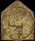
traditional mappae mundi but contain elements from other sources, including Portolan charts and maps associated with Ptolemy's Geography are sometimes considered...
14 KB (1,575 words) - 18:12, 23 August 2024
handbooks, hence the term portolan charts. The wealth of detail contained in portolano handbooks is reflected in the portolan charts, stunningly accurate...
14 KB (1,667 words) - 17:51, 26 April 2024

The map is a portolan chart with compass roses from which lines of bearing radiate. Designed for navigation via dead reckoning, portolan charts use a...
58 KB (6,183 words) - 17:18, 14 September 2024

expected of all Medieval mariners.[citation needed] In the earliest medieval portolan charts of the 14th century, compass roses were depicted as mere collections...
27 KB (2,812 words) - 15:05, 5 July 2024
flag as shown on some portolan charts The Byzantine imperial ensign of the 14th century according to Pietro Vesconte's portolan chart. The flag of Salonica...
42 KB (5,172 words) - 15:11, 9 May 2024
the Washington Map Society”, Portolan, No 49, Winter 2000-01, pp.18 Lourie, I., “The Atlases of A. J. Johnson”, Portolan, No 49, Winter 2000-01, pp.7-17...
3 KB (439 words) - 16:26, 29 September 2020

influential in Islamic science as well, whose maps were quite similar to the Portolan charts and were partly influential on the Catalan map by Abraham Cresques...
27 KB (3,745 words) - 16:47, 17 March 2023

its first explicit appearance as a large rectangular island in the 1424 portolan chart of Zuane Pizzigano. Thereafter, it routinely appeared in most nautical...
40 KB (5,237 words) - 14:57, 2 September 2024
resulted in the defining and mapping the borders between the two states. Portolan charts, which were used since the 13th century developed the technique...
44 KB (5,986 words) - 14:19, 11 September 2024

Beccario, responsible for a 1403 portolan map. Battista Beccario is the author of two notable portolan charts: 1426 portolan chart, signed and dated, "Baptista...
7 KB (824 words) - 21:03, 3 February 2024
Navigation Celestial Charts Portolan chart Rutter (nautical) Coastal Lighthouses History Piloting Pilot boat Maritime pilot By region: Inuit Micronesian...
251 KB (28,221 words) - 03:20, 11 September 2024

was a Genoese cartographer and geographer. A pioneer of the field of the portolan chart, he influenced Italian and Catalan mapmaking throughout the fourteenth...
9 KB (1,080 words) - 11:18, 14 August 2024
The Pizzigani brothers are principally known for the construction of a portolan chart, signed and dated 1367, currently held by the Biblioteca Palatina...
12 KB (1,523 words) - 22:10, 20 October 2023

Navigation Celestial Charts Portolan chart Rutter (nautical) Coastal Lighthouses History Piloting Pilot boat Maritime pilot By region: Inuit Micronesian...
191 KB (21,640 words) - 13:09, 15 September 2024

Navigation Celestial Charts Portolan chart Rutter (nautical) Coastal Lighthouses History Piloting Pilot boat Maritime pilot By region: Inuit Micronesian...
170 KB (17,335 words) - 21:28, 5 September 2024