Potaro-Siparuni (Region 8) is a region of Guyana. It borders the region of Cuyuni-Mazaruni to the north, the regions of Upper Demerara-Berbice and East...
8 KB (501 words) - 06:15, 31 August 2024

north, the region of Upper Demerara-Berbice to the east, the region of Potaro-Siparuni, and borders the Brazilian state of Roraima to the south. It covers...
7 KB (384 words) - 06:14, 31 August 2024

The Potaro River is a river in Guyana that runs from Mount Ayanganna area of the Pakaraima Mountains for approximately 255 km (158 mi) before flowing into...
9 KB (659 words) - 13:09, 2 March 2024

Mazaruni Potaro North West Rupununi West Demerara-Essequibo Coast East Berbice Essequibo Essequibo Islands North west (hinterlands) Mazaruni-Potaro (hinterlands)...
6 KB (259 words) - 00:19, 2 October 2024

The regions of Guyana are divided into three types of councils: municipal or town councils, neighbourhood democratic councils and Amerindian villages....
4 KB (306 words) - 17:40, 24 December 2023
The Siparuni River is a river in the Potaro-Siparuni Region of Guyana. It is a tributary of the Essequibo River. Tributaries of the Siparuni River include...
2 KB (286 words) - 12:30, 21 May 2024

the region of East Berbice-Corentyne to the east, and the regions of Potaro-Siparuni and Cuyuni-Mazaruni to the west. It contains Guyana's second largest...
7 KB (315 words) - 01:07, 18 December 2023

Esequibo (Region 9) is a region of Guyana. It borders the region of Potaro-Siparuni to the north, the region of East Berbice-Corentyne to the east and...
8 KB (478 words) - 06:16, 31 August 2024

south and the regions of Mahaica-Berbice, Upper Demerara-Berbice, Potaro-Siparuni and Upper Takutu-Upper Essequibo to the west. Towns in the region include...
8 KB (472 words) - 18:53, 4 August 2024

KAI, ICAO: SYKA) is an airport serving Kaieteur National Park in the Potaro-Siparuni region of Guyana. The airport is less than 1 kilometre (0.62 mi) west...
3 KB (88 words) - 09:55, 31 August 2024
Kaieteur Falls (category Potaro-Siparuni)
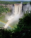
is the largest single-drop waterfall in the world. It is located on the Potaro River in Kaieteur National Park, central Essequibo Territory, Guyana. It...
6 KB (687 words) - 09:48, 31 August 2024
Orinduik (category Populated places in Potaro-Siparuni)
Orinduik is a diamond-mining community in the Potaro-Siparuni region of Guyana near the border with Brazil. The diamond production has seen a steep decrease...
7 KB (108 words) - 19:59, 14 September 2022

MHA, ICAO: SYMD) is an airport serving the village of Mahdia, in the Potaro-Siparuni Region of Guyana. The airport's only runway is a 1,067-meter grass...
2 KB (77 words) - 10:47, 31 August 2024

Yuruaní-tepui Maringma-tepui Mount Ayanganna Mount Venamo Mount Yakontipu Potaro-Siparuni Mount Kopinang Mount Wokomung See also Pacaraima Mountains...
15 KB (1,600 words) - 14:28, 27 September 2024
Kaieteur National Park (category Potaro-Siparuni)
Kaieteur National Park is a national park located in the Potaro-Siparuni Region of Guyana, roughly 633 km (393.33 miles) south of Georgetown, the nation's...
6 KB (613 words) - 14:03, 17 August 2024
Campbelltown, Guyana (category Populated places in Potaro-Siparuni)
Campbelltown is an Amerindian village in the Potaro-Siparuni Region of Guyana, north of Mahdia. The village has been named after Stephen Campbell, the...
8 KB (365 words) - 20:03, 14 September 2022

Mahdia, Guyana (category Populated places in Potaro-Siparuni)
Lucia. Mahdia being the Regional Administrative Centre of Region 8, Potaro-Siparuni has the following relevant infrastructure: A cottage hospital A nursery...
11 KB (734 words) - 15:12, 20 February 2024

Paramakatoi (category Populated places in Potaro-Siparuni)
Paramakatoi is an Amerindian community in the Potaro-Siparuni Region of Guyana, located in the Pacaraima Mountains. With an altitude of 970 metres (3...
8 KB (322 words) - 19:59, 14 September 2022
2023 Mahdia school fire (category Potaro-Siparuni)
2023, a fire broke out in a secondary school dormitory in Mahdia, Potaro-Siparuni, Guyana, killing at least 20 people. The fire was among the deadliest...
16 KB (1,438 words) - 18:51, 6 July 2024
Micobie (category Populated places in Potaro-Siparuni)
(also: Maicobi and Cassava Hill) is a village in Potaro-Siparuni, Guyana, on the right bank of the Potaro River near Tumatumari. The village was established...
7 KB (283 words) - 11:53, 19 February 2021
is a river in Potaro-Siparuni, Guyana. About 60 miles long, it is a tributary of the Essequibo River, joining it just south of the Potaro River mouth at...
2 KB (243 words) - 22:17, 20 May 2024
SYOR) is an airport serving the mining community of Orinduik in the Potaro-Siparuni Region of Guyana. Guyana portal Aviation portal List of airports in...
2 KB (58 words) - 00:56, 26 January 2022
ICAO: SYPM) is an airport serving the village of Paramakatoi, in the Potaro-Siparuni Region of Guyana. As of 2020, Trans Guyana Airways offers weekly flights...
2 KB (97 words) - 17:27, 12 July 2023
Essequibo Islands-West Demerara, Mahaica-Berbice, Pomeroon-Supenaam, Potaro-Siparuni, Upper Demerara-Berbice and Upper Takutu-Upper Essequibo. Race and...
17 KB (1,904 words) - 00:23, 13 August 2024
Yuruaní-tepui Maringma-tepui Mount Ayanganna Mount Venamo Mount Yakontipu Potaro-Siparuni Mount Kopinang Mount Wokomung See also Pacaraima Mountains...
14 KB (1,308 words) - 23:34, 26 July 2024
(850 ft) single plunge waterfall found on the Semang River in the Potaro-Siparuni highlands, southern Guyana, named for Edward VIII. Waterfall has formed...
2 KB (190 words) - 03:21, 28 November 2023
KTO, ICAO: SYKT) is an airport serving the village of Kato, in the Potaro-Siparuni Region of Guyana. The gravel airstrip is 920 meters long. The Kato...
2 KB (80 words) - 20:23, 20 August 2024

34.1% East Berbice-Corentyne 46.4% 42.1% Cuyuni-Mazaruni 5.6% 3.5% Potaro-Siparuni 6.4% 1.0% Upper Takutu-Upper Essequibo 0.5% 0.4% Upper Demerara-Berbice...
7 KB (401 words) - 12:59, 9 August 2024
El Paso, Guyana (category Populated places in Potaro-Siparuni)
El Paso is a village in the Potaro-Siparuni Region of Guyana. The village is on the Potaro River to the west of Tumatumari Falls, and Tumatumari Landing...
6 KB (170 words) - 09:29, 4 January 2021

36,234 109,431 3.02 7 Cuyuni-Mazaruni Bartica 47,213 20,280 0.43 8 Potaro-Siparuni Mahdia 20,051 10,190 0.51 9 Upper Takutu-Upper Essequibo Lethem 57...
118 KB (10,321 words) - 17:38, 30 September 2024