
Route 317 is a provincial highway in the Papineau County of the Outaouais region east of Gatineau, Quebec. The 36-kilometer highway connects Thurso, at...
2 KB (102 words) - 01:41, 25 January 2023
Route 317, or Highway 317, may refer to: Manitoba Provincial Road 317 Prince Edward Island Route 317 Quebec Route 317 Saskatchewan Highway 317 China National...
2 KB (165 words) - 23:22, 4 April 2024

Quebec's Route 389 connects Route 138 adjacent to Baie-Comeau with the Newfoundland and Labrador border, connecting with the Trans-Labrador Highway (Newfoundland...
10 KB (940 words) - 18:49, 22 June 2024
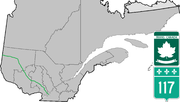
Route 117, the Trans Canada Highway Northern Route, is a provincial highway within the Canadian province of Quebec, running between Montreal and the Quebec/Ontario...
18 KB (762 words) - 21:55, 6 October 2024

Nemaska (redirect from Nemaska Reserved Territory, Quebec)
(51°19′N 76°55′W / 51.317°N 76.917°W / 51.317; -76.917). The settlement was abandoned in the mid-1970s when Hydro-Québec proposed hydro-electric development...
5 KB (379 words) - 13:15, 21 May 2024
Route 1 was a previous number used for a major highway in the Canadian province of Quebec. The highway stretched from Montreal, through the Eastern Townships...
4 KB (174 words) - 22:26, 17 March 2023
This is a list of highways maintained by the government of Quebec. The Autoroute system in Quebec is a network of expressways which operate under the same...
8 KB (547 words) - 20:07, 4 May 2024

Route 148 is an east-west highway in Quebec, Canada. It runs from junction of Autoroute 13 and Autoroute 440 in Laval in the Montreal region to the Ontario-Quebec...
13 KB (399 words) - 20:25, 2 September 2024

Route 321 is a regional road in Quebec, Canada, that consists of two unconnected sections: one in Papineau Regional County Municipality that runs from...
4 KB (177 words) - 01:40, 25 January 2023

Route 148 (running west–east) and Route 317 (running south–north). Autoroute 50, approximately 3 km north of Thurso along Route 317 complements Route...
10 KB (831 words) - 23:00, 20 November 2023

Route 315 is a road in the Canadian province of Quebec that connects the Gatineau sector of Masson-Angers to Namur. Initially, the road started in Buckingham...
5 KB (172 words) - 01:41, 25 January 2023

colony in 1769. To avert conflict in Quebec, the British Parliament passed the Quebec Act 1774, expanding Quebec's territory to the Great Lakes and Ohio...
274 KB (22,832 words) - 05:07, 19 October 2024
Saguenay–Lac-Saint-Jean region of Quebec, Canada, on the Saguenay River, about 200 kilometres (120 mi) north of Quebec City by overland route. It is about 126 kilometres...
52 KB (3,906 words) - 13:26, 15 September 2024

Maskinongé Regional County Municipality (redirect from Maskinongé County Regional Municipality, Quebec)
Maskinongé is a regional county municipality in the Mauricie region of Quebec, Canada. The seat is Louiseville. It is located adjacent on the west of Trois-Rivières...
7 KB (328 words) - 16:21, 24 June 2022

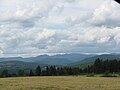
Laurentian Mountains (category Mountain ranges of Quebec)
1,000 m (3,280 ft). The Laurentian Mountains extend across Labrador and Quebec within the Laurentian Upland, which contains foothills in northeastern Ontario...
14 KB (1,383 words) - 16:01, 3 April 2024

Trans-Labrador Highway (redirect from Newfoundland and Labrador Route 500)
western/central portion of the TLH is designated as Route 500 and measures 543 km (337 mi) divided as follows: Quebec - Labrador boundary to Labrador City/Wabush...
26 KB (1,552 words) - 01:55, 11 October 2024

Colorado State Highway 35 (redirect from Quebec Street)
State Highway 35 (SH 35) is an unsigned, 1.317-mile (2.120 km) state highway that runs along Quebec Street located in Denver, Colorado, United States....
5 KB (456 words) - 05:41, 8 February 2024

route from Edmundston, New Brunswick, west to Quebec Route 289 toward Saint-Alexandre-de-Kamouraska, Quebec. The direct predecessor to US 1 was the Atlantic...
56 KB (5,381 words) - 17:09, 8 October 2024
main route of the Trans-Canada Highway from the A-25 interchange to the A-85 interchange. At 585 km (363.5 mi), it is the longest Autoroute in Quebec. It...
48 KB (1,778 words) - 22:27, 19 August 2024

The Invasion of Quebec (June 1775 – October 1776, French: Invasion du Québec) was the first major military initiative by the newly formed Continental Army...
65 KB (7,857 words) - 23:15, 21 September 2024
The Quebec North Shore and Labrador Railway is a private Canadian regional railway that stretches 414 kilometres (257 mi) through the wilderness of northeastern...
10 KB (967 words) - 14:13, 10 May 2024

Montreal–Jonquière train (category Via Rail routes)
operated by Via Rail between Montreal and Saguenay (borough of Jonquière) in Quebec, Canada. The train once operated as far as Chicoutimi. The journey, from...
3 KB (163 words) - 08:09, 18 May 2024

New England road marking system (redirect from New England Interstate Route 17)
toward Quebec. Route 12 was replaced by Connecticut Route 32 from New London to Norwich, Connecticut Route 12 north of Norwich, Massachusetts Route 12, New...
158 KB (6,445 words) - 17:10, 1 February 2024

Wôlinak (redirect from Wolinak 11, Quebec)
Wôlinak is an Abenaki First Nations reserve in the Centre-du-Québec region, Quebec, Canada. An enclave within the city of Bécancour, it was one of the...
9 KB (709 words) - 20:38, 1 March 2024
Mount Raoul Blanchard (category One-thousanders of Quebec)
who had significant interest in the French Alps and the mountains of Quebec. Peakbagger 47°19′N 70°50′W / 47.317°N 70.833°W / 47.317; -70.833 v t e...
967 bytes (102 words) - 20:20, 2 June 2021

Bécancour Regional County Municipality (redirect from Bécancour County Regional Municipality, Quebec)
Bécancour is a regional county municipality in the Centre-du-Québec region of Quebec, Canada. Its seat is Bécancour. There are 12 subdivisions and one...
6 KB (149 words) - 20:54, 16 January 2024

Valcourt (town) (redirect from Valcourt, Quebec (town))
town in Quebec in Le Val-Saint-François Regional County Municipality in the Estrie region of Quebec. The town is accessible via Quebec Route 222. The...
9 KB (503 words) - 17:06, 25 August 2024
List of highways numbered 1 (redirect from State Route 1)
Nova Scotia Trunk 1 Northwest Territories Highway 1 Quebec Route 1 (former) Yukon Highway 1 Chile Route 1 G1 Expressway G1N Expressway G0111 Expressway S01...
20 KB (1,282 words) - 08:59, 27 August 2024
Ontario Highway 407 (redirect from 407 Express Toll Route)
Comprising a privately leased segment and a publicly owned segment, the route spans the entire Greater Toronto Area (GTA) around the city of Toronto,...
108 KB (8,359 words) - 07:14, 14 October 2024

New France (redirect from French Quebec)
Edward (2005). The Road to Canada: The Grand Communications Route from Saint John to Quebec. Goose Lane Editions and The New Brunswick Heritage Military...
125 KB (14,418 words) - 16:17, 18 October 2024