
The Qvirila (Georgian: ყვირილა) is a river of Georgia. It is 140 km (87 mi) long, and has a drainage basin of 3,630 km2 (1,400 sq mi). It is a left affluent...
2 KB (174 words) - 03:12, 31 August 2024

Oni. Its largest tributaries are, from source to mouth: Jejora (left), Qvirila (left), Khanistsqali (left), Tskhenistsqali (right) and Tekhuri (right)...
7 KB (558 words) - 06:49, 29 August 2024

The city is located inland, in a mountain valley on the banks of the Qvirila River. In 1879 the Georgian poet Akaki Tsereteli explored the area in search...
10 KB (885 words) - 03:11, 31 August 2024

settlements developed mostly in Western Georgia, in the valleys of the Rioni and Qvirila rivers. Signs of agriculture date back to at least the 6th millennium BC...
227 KB (21,446 words) - 13:12, 30 August 2024

furthest east of the Colchis Plateau, and is built on both banks of the Qvirila River. It is an important industrial center, with a large ferro-alloy plant...
12 KB (816 words) - 23:02, 9 July 2024
(Georgian: წონის მღვიმე) is an archaeological site at the head of the river Qvirila in proximity of village Tson [ka] (Georgian: წონა, Ossetian: Цъон) in the...
3 KB (252 words) - 19:05, 12 September 2023

drainage basin of 1,270 km2 (490 sq mi). It is a right tributary of the Qvirila, which it joins east of the town Zestaponi. Wikimedia Commons has media...
1 KB (67 words) - 15:44, 28 March 2024

lake in the Java Municipality, Shida Kartli region of Georgia. Located in Qvirila river basin, north-west side of the Ertso-Tsona depression, at 1710 m above...
3 KB (233 words) - 05:28, 15 April 2022
"very poorly documented". In contrast, recent excavations in the Valley of Qvirila river, to the north of the Trialetian region, display a Mesolithic culture...
18 KB (1,990 words) - 21:13, 27 December 2023

church stands on a mountain slope at the village of Eto-Ekhvevi, in the Qvirila River valley, 10 km east of the town of Sachkhere, in the Sachkhere Municipality...
4 KB (378 words) - 15:41, 14 January 2024

Kura→ Dzirula 83 km (52 mi) 83 km (52 mi) 1.27 km2 (0.49 sq mi) Black Sea, Qvirila→ Rioni→ Enguri 206 km (128 mi) 206 km (128 mi) 4.1 km2 (1.6 sq mi) Black...
9 KB (386 words) - 15:12, 21 May 2024
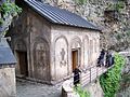
The Mghvimevi monastery is situated in the eponymous village, in the Qvirila River valley, at the eastern edge of Chiatura, from where it can be accessed...
7 KB (654 words) - 14:17, 9 February 2024
church at the headwaters of the Jruchula, a right-bank affluent of the Qvirila River near the modern-village of Tskhomareti, Sachkhere Municipality, on...
6 KB (559 words) - 07:29, 8 April 2023

Darkveti church stands on the right bank of the Jruchula, a tributary of the Qvirila River, in the eponymous village, in the Chiatura Municipality, Imereti...
4 KB (408 words) - 15:36, 31 January 2021

is perched atop a high Mount Kvirike near the village of Speti, in the Qvirila River valley, 16 km east of the town of Sachkhere, in the Sachkhere Municipality...
5 KB (478 words) - 15:23, 9 December 2022

Significance. The Savane church stands on a hill on the left bank of the Qvirila River, a tributary of the Rioni, in the centre of the eponymous village...
6 KB (649 words) - 09:01, 10 February 2021