The Ribble way is a long-distance walk between the Lancashire coast and the Yorkshire Dales National Park largely following the course of the River Ribble...
8 KB (773 words) - 12:32, 25 May 2023

The River Ribble runs through North Yorkshire and Lancashire in Northern England. It starts close to the Ribblehead Viaduct in North Yorkshire, and is...
30 KB (2,894 words) - 01:32, 30 July 2024

of Whernside. The Pennine Way visits Horton and crosses the summit of Pen-y-ghent. The Ribble Way follows the River Ribble from its source near the foot...
11 KB (1,302 words) - 21:19, 15 September 2024
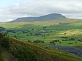
The Yorkshire Three Peaks rise to the east and west of the dale. The Ribble Way runs the length of the dale. At the head of the dale is the Ribblehead...
3 KB (295 words) - 17:38, 8 September 2024
Preston Dock (redirect from River Ribble Navigation Act 1838)
Preston Dock is a former maritime dock on the northern bank of the River Ribble, 2.5 km (1.6 mi) west of Preston, Lancashire, England. The Albert Edward...
78 KB (10,218 words) - 17:01, 15 September 2024
Ribblehead the Dales Way briefly coincides with the Pennine Way and the Pennine Bridleway. At Ribblehead the trail connects with the Ribble Way. Just before it...
11 KB (1,255 words) - 21:27, 15 July 2024

Britain. Laviscount was born in Burnley, Lancashire, and grew up in Read, Ribble Valley in Lancashire. He was born to Eugene Laviscount, a body builder of...
15 KB (1,032 words) - 00:42, 7 September 2024

Gisburn (category Geography of Ribble Valley)
Gisburn (formerly Gisburne) is a village and civil parish within the Ribble Valley borough of Lancashire, England. Historically within the West Riding...
15 KB (1,439 words) - 01:29, 1 August 2024

The Ribble Steam Railway is a standard gauge preserved railway in Lancashire, in the United Kingdom. It was opened to the public on 17 September 2005,...
7 KB (761 words) - 14:27, 9 May 2024

Walton-le-Dale, where the bypass ends. The A6 crosses the River Ribble and the Ribble Way, entering Preston district. It enters Preston as a single carriageway...
35 KB (4,402 words) - 07:45, 7 September 2024

Longton, Lancashire (category Geography of South Ribble)
Longton is a village and civil parish in the west of the borough of South Ribble, Lancashire, England. It is about 4 miles to the south west of Preston....
12 KB (1,312 words) - 16:19, 12 February 2024

starting (and finishing) point for the Three Peaks walk. The Pennine Way and Ribble Way long-distance footpaths pass through the village. The region is also...
9 KB (1,034 words) - 07:24, 21 August 2024

the western bank of the River Ribble in North Yorkshire, England. Stackhouse lies on the western side of the River Ribble in north Ribblesdale, opposite...
8 KB (673 words) - 23:54, 9 November 2023

the Ribble and Alt Estuaries National nature reserve. The major rivers in the county are, from north to south, the Lune, the Wyre, and the Ribble, which...
96 KB (8,681 words) - 09:06, 6 September 2024
Way Middle Intake Farm alongside the Brontë Way A bog on the Coast to Coast Walk next to St Sunday Crag Harber Scar Lane which carries the Ribble Way...
96 KB (2,055 words) - 11:32, 20 August 2024

Millennium Ribble Link is a linear water park and new navigation which links the once-isolated Lancaster Canal in Lancashire, England to the River Ribble. The...
49 KB (6,477 words) - 22:39, 31 May 2024

Preston, Lancashire (section River Ribble)
Preston (/ˈprɛstən/ ) is a city on the north bank of the River Ribble in Lancashire, England. The city is the administrative centre of the county of Lancashire...
148 KB (14,984 words) - 01:19, 18 September 2024
Rimington (category Geography of Ribble Valley)
Rimington is a rural village and civil parish in the Ribble Valley, Lancashire, England. The population of the civil parish was 382 at the 2001 Census...
8 KB (700 words) - 02:06, 31 July 2024

Clitheroe (category Geography of Ribble Valley)
Clitheroe (/ˈklɪðəroʊ/) is a town and civil parish in the Borough of Ribble Valley, Lancashire, England; it is located 34 miles (55 km) north-west of Manchester...
36 KB (3,458 words) - 17:56, 2 August 2024

Penwortham (category Geography of South Ribble)
(/ˈpɛnwərðəm/) is a town and civil parish in South Ribble, Lancashire, England, on the south bank of the River Ribble facing the city of Preston. The town is at...
15 KB (1,593 words) - 20:41, 17 August 2024

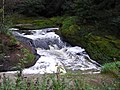
(also known as Stainforth Foss and Ribble Falls), is a 2.5-metre (8 ft 2 in) high cascade waterfall on the River Ribble at Stainforth, 3 miles (5 km) north...
6 KB (496 words) - 21:20, 28 April 2024

Leyland, Lancashire (category Geography of South Ribble)
Leyland (/ˈleɪlənd/ LAY-lənd) is a town in South Ribble, Lancashire, England, 6 miles (10 km) south of Preston. The population was 35,578 at the 2011 Census...
20 KB (1,607 words) - 19:10, 21 August 2024

The Ribble Valley line is a railway line that runs from Manchester Victoria through Blackburn, in Lancashire, to Hellifield in North Yorkshire. Regular...
22 KB (2,288 words) - 15:43, 2 September 2024

the village. The village is also along the route of the Ribble Way. Field Day Parade River Ribble near Elston Lane Grimsargh War Memorial Lancashire portal...
9 KB (984 words) - 08:59, 25 June 2024

into the Ribble without mixing together. The Pennine Way links the summit to the village; the route is around 3.1 miles (5 km) in length as the Way curves...
10 KB (1,052 words) - 22:25, 14 September 2024

This is a list of crossings of the River Ribble in Northern England. Map all coordinates using OpenStreetMap Download coordinates as: KML GPX (all coordinates)...
15 KB (112 words) - 09:53, 26 April 2024

Paythorne (category Geography of Ribble Valley)
a small village and civil parish in Ribble Valley, Lancashire, England. It is situated alongside the River Ribble, north-east of Clitheroe, and on the...
8 KB (657 words) - 01:41, 1 August 2024
River Darwen (category Ribble catchment)
Lancashire, England, eventually joining the River Ribble at Walton le Dale south of Preston on its way to the Ribble Estuary. Originating at Jack's Key Clough...
7 KB (662 words) - 05:36, 10 March 2024

route has operated continuously since 1948. It was previously operated by Ribble Motor Services, Stagecoach North West and Burnley & Pendle, while GM Buses...
23 KB (2,415 words) - 14:18, 28 August 2024

Surakarta, Indonesia A Berninabahn train crossing the main square in Tirano Ribble Steam Railway street running in Preston Dock Columbus & Chattahoochee Railroad...
4 KB (361 words) - 07:09, 10 September 2024