
A50 motorway (Netherlands) (redirect from Rijksweg 50)
A50, the section of Rijksweg 50 that is constructed as controlled-access highway, is a north–south motorway in the Netherlands, running from Eindhoven...
11 KB (354 words) - 22:11, 14 December 2022
"Verbreding A58 is nodig, maar kan het ook?". 3 Apr 2011. Archived from the original on Apr 5, 2012. Media related to Rijksweg 58 at Wikimedia Commons...
10 KB (426 words) - 11:31, 4 July 2024

A2 motorway (Netherlands) (redirect from Rijksweg 2)
lanes started on December 13, 2011. Wikimedia Commons has media related to Rijksweg 2. "Wegbeheerders". Rijkswaterstaat. Retrieved 27 December 2016. "Actuele...
21 KB (747 words) - 09:31, 27 September 2023

A9 motorway (Netherlands) (redirect from Rijksweg 9)
highway (called N9) and continues along: Alkmaar Schoorl Schagerbrug 't Zand Julianadorp De Kooy Wikimedia Commons has media related to Rijksweg 9. Map...
6 KB (339 words) - 07:04, 27 January 2021

A27 motorway (Netherlands) (redirect from Rijksweg 27)
Gorinchem, Utrecht and Hilversum. Although not officially a part of the Rijksweg 27, the section of the A58 motorway between interchanges Galder and Sint-Annabosch...
9 KB (244 words) - 05:21, 20 March 2023

A28 motorway (Netherlands) (redirect from Rijksweg 28)
section of the A28 is the complete E232 route; the E232 does not consist of any other road or section. Media related to Rijksweg 28 at Wikimedia Commons...
12 KB (293 words) - 23:58, 15 February 2023

A4 motorway (Netherlands) (redirect from Rijksweg 4)
The A4 motorway, also called Rijksweg 4, is a motorway in the Netherlands running southwards from Amsterdam to the Belgian border near Zandvliet, north...
35 KB (3,377 words) - 23:08, 27 April 2023

route of the A16 motorway between the Terbregseplein in Rotterdam and the Belgian border near Breda. Media related to Rijksweg 16 at Wikimedia Commons...
7 KB (284 words) - 12:40, 18 June 2024
(Morocco) National Highway 1 (Myanmar) A1 road (Namibia) Mahendra Highway Rijksweg 1 New Zealand State Highway 1 New Zealand State Highway 1B New Zealand...
20 KB (1,269 words) - 07:41, 30 May 2024

/ Geldropseweg Someren 37.3 23.2 35 Someren N 266 south (Rijksweg) / N 612 north (Rijksweg) – Someren, Lierop, Helmond Asten 42.0 26.1 36 Asten, Netherlands...
6 KB (61 words) - 22:47, 22 July 2021

N57, or rijksweg 57, is a 77 km long national road in the provinces of South Holland and Zeeland in the Netherlands. It is also known as the dammenroute...
2 KB (107 words) - 23:04, 20 January 2024

Hooipolder E312 (Highway 58) - Sint Annabosch The entire route is constructed as a motorway and is part of Highway 27 (Rijksweg A27). Before the renumbering...
3 KB (152 words) - 12:20, 20 September 2021

58 51°01′59″N 5°43′58″E / 51.03310°N 5.73269°E / 51.03310; 5.73269 (Relictid 88652 -) 88652 Info Two houses mirror (nl) Dilsen-Stokkem Rijksweg 102...
33 KB (56 words) - 03:09, 8 March 2022

is in Ridderkerk, South Holland Province. Media related to Rijksweg 38 at Wikimedia Commons 51°52′55″N 4°34′48″E / 51.8819°N 4.58°E / 51.8819; 4.58...
2 KB (177 words) - 10:28, 27 January 2021

possibility to travel between the Dutch A67 and the German A61 without having to leave the motorway. Media related to Rijksweg 67 at Wikimedia Commons...
6 KB (175 words) - 13:07, 6 May 2023
via Orhei and the route arrives at Soroca, on the border with Ukraine Rijksweg 2 National road 2 (DK2) Motorway of Freedom (A2/E30) expressway S2, Southern...
18 KB (1,120 words) - 21:01, 5 June 2024
Leeuwarden station. Leeuwarden 0 km (0 mi) Leeuwarden Rijksweg 3 km (1.9 mi) Leeuwarden Rijksweg (or Halte) station was demolished in 1970 Jelsum 5 km...
9 KB (610 words) - 08:46, 18 July 2024
Gwydir Highway G76 Expressway National Route 76 Mexican Federal Highway 76 Rijksweg A76 New Zealand State Highway 76 N76 highway (Philippines) Interstate 76...
5 KB (379 words) - 22:41, 4 April 2024
the province of Limburg, 10 x Circuit (10 x 16.125 km) Circuit = west on Rijksweg in Vilt, continuing through Berg en Terblijt onto Bergerstraat, turning...
17 KB (482 words) - 01:47, 29 June 2024
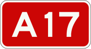
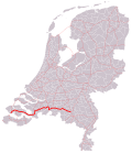
which is located in the western part of the city. The entire route is in North Brabant Province. Media related to Rijksweg 17 at Wikimedia Commons v t e...
3 KB (90 words) - 00:22, 1 August 2021

Klaaswaal and the southern terminus, near Dinteloord, is officially a part of Rijksweg number 4. However, until that road's missing link between Rotterdam (at...
3 KB (101 words) - 23:53, 15 February 2023

(Beugenseweg) – Boxmeer, Beugen Limburg (Netherlands) Gennep 7.6 4.7 2 Gennep N 271 (Rijksweg) – Gennep, Heijen, Afferden, Limburg, Nieuw-Bergen 11.1 6.9 — — E31 / A...
10 KB (58 words) - 22:47, 22 July 2021
Airport) National Route 4 FT 4 Malaysia Federal Route 4 M4 highway (Moldova) Rijksweg 4 New Zealand State Highway 4 Nicaraguan Highway 4 Nigeria Trunk Road A4...
14 KB (973 words) - 19:04, 21 July 2024
which was marked on a map dated 1664. It stood on the west side of the Rijksweg at 53°11′48″N 5°47′47″E / 53.196603°N 5.796389°E / 53.196603; 5.796389...
75 KB (9,607 words) - 04:20, 31 January 2024