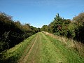
The Roman Road in Cambridgeshire, also known as Worsted Street Roman Road, is a 12.4-hectare (31-acre) linear biological Site of Special Scientific Interest...
4 KB (271 words) - 11:57, 25 July 2024

2011. "Cambridgeshire HER: Prehistoric and Roman remains, Reach Road, Burwell". Heritage Gateway. Retrieved 13 November 2011. "Cambridgeshire HER: Probable...
46 KB (4,486 words) - 21:56, 1 April 2024
Akeman Street is the name given to a Roman road in eastern England that runs from Cambridgeshire to the north coast of Norfolk. It is approximately 75...
2 KB (229 words) - 09:27, 4 April 2024
on the Cambridgeshire Dykes and Worsted Street Roman Road" (PDF). Proceedings of the Cambridge Antiquarian Society. 85: 27–122. Cambridgeshire Historic...
11 KB (1,155 words) - 11:24, 18 April 2024

Godmanchester (redirect from Godmanchester, Cambridgeshire)
of Cambridgeshire, England. It is separated from Huntingdon, 1 mile (1.6 km) to the north, by the valley of the River Great Ouse. Being on the Roman road...
26 KB (2,473 words) - 06:06, 16 July 2024

Roman roads in Britannia were initially designed for military use, created by the Roman army during the nearly four centuries (AD 43–410) that Britannia...
39 KB (3,425 words) - 21:01, 15 February 2024

is a Fenland market town and civil parish in the Isle of Ely area of Cambridgeshire, England. It was the county town of the Isle of Ely which was a separate...
27 KB (3,388 words) - 07:05, 12 June 2024

EE-lee) is a cathedral city and civil parish in the East Cambridgeshire district of Cambridgeshire, England, about 14 miles (23 km) north-northeast of Cambridge...
143 KB (14,418 words) - 18:29, 30 July 2024
roads south-west of King's Lynn town centre. The route passes through or around primary destinations in Greater London, Hertfordshire, Cambridgeshire...
33 KB (1,834 words) - 12:32, 9 July 2024
is a small rural village and civil parish in the South Cambridgeshire district of Cambridgeshire, England. It is 9 miles west of the county town of Cambridge...
9 KB (997 words) - 18:46, 22 June 2022
medieval market town and civil parish in the Huntingdonshire district in Cambridgeshire, England, 5 miles (8 km) east of Huntingdon and 12 miles (19 km) north-west...
37 KB (4,170 words) - 23:13, 2 August 2024
village and civil parish of about 1,600 households, and 4,500 people, in Cambridgeshire, England. It lies about 2 miles (3 km) to the northwest of Cambridge...
11 KB (1,115 words) - 09:29, 5 June 2024
Icknield Way Path (category Footpaths in Cambridgeshire)
Hertfordshire Chain Walk, Hertfordshire Way, Peddars Way, Ridgeway, the Roman Road, Cambridgeshire, Stour Valley Path and Swan's Way. The path was devised by the...
5 KB (507 words) - 13:18, 7 August 2024

St Neots in Cambridgeshire. It lies to the east of the River Great Ouse, to the south of Hen Brook, and to the north-west of the A428 road (St Neots by-pass)...
28 KB (3,831 words) - 15:53, 9 August 2024
is a market town and civil parish in the Huntingdonshire district of Cambridgeshire, England. The town is about 9 miles (14 km) north of Huntingdon. Ramsey...
22 KB (2,442 words) - 11:03, 20 February 2024

Ermine Street (redirect from Old North Road)
Arrington, Cambridgeshire, and Royston, Hertfordshire. "Armingford", and "Arrington" share the same Old English origin. The original Celtic and Roman names...
9 KB (1,019 words) - 13:14, 17 December 2023
The area has bus and road connections to the centre of Cambridge as well as the A14 trunk road. Services on the Cambridgeshire Guided Busway began in...
5 KB (437 words) - 20:01, 24 June 2024

Via Devana (redirect from Gartree Road)
Via Devana is the name given to a Roman Road in England that ran from Colchester in the south-east, through Cambridge in the interior, and on to Chester...
5 KB (514 words) - 03:29, 17 February 2023
Cambourne (redirect from Cambourne, Cambridgeshire)
and civil parish in Cambridgeshire, England, in the district of South Cambridgeshire. It is a new settlement and lies on the A428 road between Cambridge...
24 KB (2,742 words) - 21:15, 28 July 2024
Fen Causeway (redirect from Fen Road)
Fen Causeway or the Fen Road is the modern name for a Roman road of England that runs between Denver, Norfolk in the east and Peterborough in the west...
2 KB (191 words) - 21:16, 19 October 2022

Wesminster it is part of the South Cambridgeshire constituency. Arrington village and parish are mostly west of the A1198 road, with the exception of a small...
7 KB (601 words) - 08:10, 17 February 2022
Wintringham (category Villages in Cambridgeshire)
St Neots, Cambridgeshire, England. It is located on the eastern side of the town, east of the East Coast main line and next to the A428 road. The site...
2 KB (153 words) - 06:14, 8 January 2024

Icknield Way (category Roman roads in England)
of the oldest roads the route of which can still be traced, being one of the few long-distance trackways to have existed before the Romans occupied the...
16 KB (1,825 words) - 13:12, 7 August 2024

Soham (redirect from Soham, Cambridgeshire)
SOH-əm) is a town and civil parish in the district of East Cambridgeshire, in Cambridgeshire, England, just off the A142 between Ely and Newmarket. Its...
20 KB (2,245 words) - 08:36, 3 August 2024

Kimbolton is a town and civil parish in the Huntingdonshire district of Cambridgeshire, England. Kimbolton is about 9 miles (14 km) west of Huntingdon and...
19 KB (1,954 words) - 19:12, 9 August 2024

Barton is a village and civil parish in the South Cambridgeshire district of Cambridgeshire, England. It is about 4 miles (6.4 km) south-west of Cambridge...
12 KB (853 words) - 23:41, 3 November 2023

Cambridge (redirect from Cambridge, Cambridgeshire)
non-metropolitan district in the county of Cambridgeshire, England. It is the county town of Cambridgeshire and is located on the River Cam, 55 miles (89 km)...
171 KB (14,324 words) - 17:07, 3 August 2024

Waterbeach (redirect from Waterbeach, Cambridgeshire)
the South Cambridgeshire district of Cambridgeshire, England. It was designated a "new town" in 2018. Waterbeach is on the Car Dyke, a Roman waterway traceable...
14 KB (1,346 words) - 05:15, 5 July 2024
Hardwick. It lies in Huntingdonshire, a non-metropolitan district of Cambridgeshire and a historic county, close to three transport routes of past and present:...
46 KB (5,144 words) - 01:11, 8 July 2024

Stilton (category Villages in Cambridgeshire)
in Cambridgeshire, England, about 12 miles (19 km) north of Huntingdon in Huntingdonshire, which is a non-metropolitan district of Cambridgeshire as well...
18 KB (2,117 words) - 11:14, 1 April 2024