Highway 989 is a regional route in the northern Golan, connecting Sa'ar on Highway 99 with Majdal Shams on Highway 98. The road was paved by the Jewish...
3 KB (188 words) - 23:44, 10 February 2024
Route 978 is a regional north-south Israeli highway in the Golan Heights. Survey of Israel (October 31, 2018). "מחוזות משרד הפנים" [Ministry of Interior...
2 KB (57 words) - 21:27, 24 April 2024
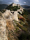
Nimrod Castle (category Medieval sites on the Golan Heights)
feet) above sea level. It overlooks the Golan Heights and was built with the purpose of guarding a major access route to Damascus against armies coming from...
12 KB (1,271 words) - 00:12, 27 April 2024

Route 999 is an east–west regional route in the northern Golan Heights, which Israel captured from Syria in the Six-Day War in 1967. Its access is restricted...
3 KB (272 words) - 22:18, 14 April 2024
List of Israeli highways (redirect from Route 395 (Israel))
highways in Israel proper, it includes highways in the West Bank and the Golan Heights because the Israeli administration maintains them in these areas. There...
26 KB (370 words) - 01:34, 4 July 2024
Israeli side of the Golan Heights. It is shaped like an archer's bow, and it runs parallel to the ceasefire line with Syria. The route runs from Tzemah junction...
6 KB (218 words) - 17:48, 21 June 2024
highway in the Finger of the Galilee in far northeast of Israel and the Golan Heights. It begins in the west at HaMetzodot junction in Kiryat Shmona, and...
3 KB (171 words) - 21:18, 6 April 2024
along its route, which usually makes it very slow compared to express buses. Express and direct buses are usually on long-distance routes and might travel...
67 KB (752 words) - 14:41, 3 August 2024