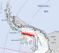
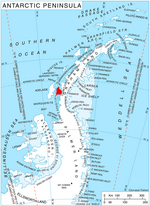
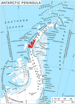
Rymill Bay (68°24′S 67°05′W / 68.400°S 67.083°W / -68.400; -67.083 (Rymill Bay)) is a bay, 9 nautical miles (17 km; 10 mi) wide at its mouth and indenting...
7 KB (1,218 words) - 16:12, 12 July 2024
from 1938 to 1950 Cape Rymill, Antarctica Mount Rymill, Antarctica Rymill Bay, Antarctica Rymill Coast, Antarctic Peninsula Rymill House, an historic building...
1 KB (171 words) - 07:04, 8 September 2022
Valley and Lammers Glacier define the south side. Bertrand Ice Piedmont, Rymill Bay and Neny Fjord are on the northwest side. Snowshoe Glacier and Remus Glacier...
9 KB (1,439 words) - 23:08, 6 May 2024
supervillain Romulus Thread, a Hunger Games character Romulus Glacier, Rymill Bay, Graham Land, Antarctica; a glacier Mount Romulus, Little Elbow River...
4 KB (532 words) - 03:50, 22 August 2024

Riddoch Rymill (13 March 1905 – 7 September 1968) was an Australian polar explorer, who had the rare second clasp added to his Polar Medal. Rymill was born...
7 KB (698 words) - 14:00, 3 May 2024
Neny Fjord (redirect from Neny Bay)
Inlet and Solberg Inlet, and north of Red Rock Ridge, Hadley Upland and Rymill Bay. Glaciers feeding the fjord are, from south to north, Remus Glacier, Snowshoe...
12 KB (1,980 words) - 16:12, 12 July 2024
Mikkelsen Bay is in the east of the larger Marguerite Bay in Graham Land on the Fallières Coast of the Antarctic Peninsula. It is south of Rymill Bay and the...
10 KB (1,690 words) - 16:12, 12 July 2024
adjoining ridges into the north part of the Bertrand Ice Piedmont in Rymill Bay on the Fallières Coast. It was named by Argentina in 1978 to honor its...
566 bytes (89 words) - 14:23, 12 February 2023
56°39′32″W / 64.226468°S 56.658831°W / -64.226468; -56.658831 El Plumerillo Rymill Bay Argentina 1953 Summer refuge Closed San Martín 68°20′00″S 67°10′00″W...
61 KB (517 words) - 15:12, 27 February 2024
Northeast Glacier (redirect from Back Bay (Antarctica))
Island, lying in Marguerite Bay off the west coast of Graham Land. First roughly charted in 1936 by the BGLE under John Rymill. The islands were surveyed...
11 KB (1,900 words) - 20:37, 11 September 2024
an Antarctic refuge located on one islet of the Refuge Islands in the Rymill Bay on the Fallières Coast. The refuge is operated by the Argentine Army and...
4 KB (324 words) - 15:30, 30 May 2023

Land Expedition (BGLE) under John Rymill, and in 1948 by the Falkland Islands Dependencies Survey (FIDS). The bay is named for Lisle C.D. Ryder, second...
5 KB (551 words) - 08:56, 30 January 2024
Graham Land Expedition, 1934–37, under John Rymill. Gerlache Strait Geology Anvers Island Geology "Hackapike Bay". Geographic Names Information System. United...
823 bytes (108 words) - 23:09, 26 August 2024

named by the British Graham Land Expedition (BGLE) (1934–37) under John Rymill. The BGLE base was on Barry Island, in the center of the group, during part...
5 KB (607 words) - 16:25, 2 May 2024

northeast part of Marguerite Bay, Antarctica. It was first surveyed in 1936–37 by the British Graham Land Expedition under John Rymill, and was visited by the...
997 bytes (138 words) - 16:03, 20 August 2024

discovered by the British Graham Land Expedition, 1934–37, and named by John Rymill for Professor Olaf Holtedahl, a Norwegian geologist who conducted geologic...
1 KB (182 words) - 23:11, 26 August 2024
under Rymill. Broken Island and Centre Island lie in the north part of the bay. This article incorporates public domain material from "Square Bay". Geographic...
859 bytes (128 words) - 01:21, 17 April 2021
charted by the British Graham Land Expedition under John Rymill, 1934–1937, who named the bay for its southern entrance point, Cape Calmette. This article...
557 bytes (80 words) - 07:20, 18 August 2024
along Marguerite Bay. It was named by the United Kingdom Antarctic Place-Names Committee (UK-APC) in 1985 after John Riddoch Rymill (1905–68), Australian...
2 KB (258 words) - 00:59, 1 June 2024

The Lady Franklin Bay Expedition of 1881–1884 (a.k.a. the Greely Expedition) to Lady Franklin Bay on Ellesmere Island in the Canadian Arctic was led by...
12 KB (1,331 words) - 22:30, 29 September 2024

European to see Hudson Strait and the immense Hudson Bay. In 1611, after wintering on the shore of James Bay, Hudson wanted to press on to the west, but most...
29 KB (3,596 words) - 16:05, 7 August 2024
re-charted by the British Graham Land Expedition, 1934–37, under John Rymill. "Barilari Bay". Geographic Names Information System. United States Geological...
1,012 bytes (138 words) - 18:35, 21 November 2015

Greenland (redirect from Kangat Bay)
Saqqaq culture. Most finds of remains from that period have been around Disko Bay, including the site of Saqqaq, for which the culture is named. From 2400 BC...
179 KB (16,910 words) - 00:23, 16 October 2024
Magnier Peaks separates this bay from Leroux Bay. It was named by John Rymill after Mount Bigo, a mountain at the head of the bay. Antarctic Digital Database...
1 KB (173 words) - 16:23, 2 December 2022

roughly surveyed in 1936 by the British Graham Land Expedition under John Rymill. It was resurveyed in 1948 by the Falkland Islands Dependencies Survey (FIDS)...
1 KB (161 words) - 07:54, 19 October 2022
Edith Ronne Finn Ronne James Clark Ross John Ross Vladimir Rusanov John Rymill Rudolf Samoylovich Yakov Sannikov Ben Saunders Otto Schmidt William Scoresby...
6 KB (523 words) - 20:01, 10 July 2024
Arrowsmith Peninsula (redirect from Whistling Bay)
in 1937 by the British Graham Land Expedition (BGLE) under John Riddoch Rymill and named in 1954 for Otto Schmidt, director of the Arctic Institute at...
8 KB (953 words) - 11:22, 26 June 2023
Discovery II, and by the British Graham Land Expedition, 1934–37, under John Rymill. Antarctic Digital Database (ADD). Scale 1:250000 topographic map of Antarctica...
2 KB (178 words) - 22:08, 30 January 2023
surveyed in 1936 by the British Graham Land Expedition (BGLE) under John Rymill and was photographed from the air in 1940 by the United States Antarctic...
1 KB (151 words) - 05:08, 15 April 2022
part of Square Bay, off the west coast of Graham Land. Discovered and named by the British Graham Land Expedition (BGLE) under Rymill, 1934–37. List of...
615 bytes (102 words) - 15:50, 8 February 2024