The San Pablo Fault is a fault in northern California. It is an offshoot of the Hayward Fault. It formed the Potrero Hills in Richmond, California. Point...
903 bytes (48 words) - 20:24, 10 April 2023

Hayward. North of San Pablo Bay is the Rodgers Creek Fault, which was shown in 2016 to be linked with the Hayward Fault under San Pablo Bay to form a combined...
55 KB (6,712 words) - 09:13, 17 July 2024

city. The northeastern limits of San Pablo are also traversed by the Hayward Fault, a major branch of the San Andreas Fault, which lies to the west. Interstate...
21 KB (1,941 words) - 20:44, 31 July 2024

In geology, a fault is a planar fracture or discontinuity in a volume of rock across which there has been significant displacement as a result of rock-mass...
33 KB (3,705 words) - 04:54, 22 July 2024

Championships on San Pablo. In October 2004, a study commissioned by EBMUD concluded that a major earthquake on the Hayward Fault could cause the San Pablo Dam to...
8 KB (805 words) - 13:53, 11 August 2023

Potrero Hills (Richmond, California) (category San Pablo Bay)
north. They were formed by pressure created by the San Pablo Fault a sub-fault of the Hayward Fault. Part of the hills once were cultivated as a vineyard...
4 KB (333 words) - 17:06, 23 September 2021

estuaries of San Francisco Bay, San Pablo Bay, and Suisun Bay: Alameda, Contra Costa, Marin, Napa, San Mateo, Santa Clara, Solano, Sonoma, and San Francisco...
251 KB (21,145 words) - 22:03, 15 August 2024
1898 Mare Island earthquake (category History of the San Francisco Bay Area)
within the confines of the San Pablo Bay National Wildlife Refuge. One of the numerous strike-slip faults of the San Andreas Fault System in the North Bay...
15 KB (1,733 words) - 01:49, 30 May 2024

San Diego Bay is "the surface expression of a north-south-trending, nested graben". The Rose Canyon and Point Loma fault zones are part of the San Andreas...
190 KB (17,277 words) - 00:50, 17 August 2024

Richmond, California (category Cities in the San Francisco Bay Area)
and has a city council. Located in the San Francisco Bay Area's East Bay region, Richmond borders San Pablo, Albany, El Cerrito and Pinole in addition...
153 KB (15,464 words) - 14:02, 16 August 2024

Vallejo, California (category Cities in the San Francisco Bay Area)
south and the San Pablo Bay to the west. Several faults have been mapped in the vicinity of Vallejo. The San Andreas Fault and Hayward Faults are the most...
58 KB (4,674 words) - 13:37, 16 August 2024
"Good" and reads "It's a true-to-life account, sometimes to a fault, of the rise of Pablo Escobar and the hunt that brought him down laced with stellar...
30 KB (2,168 words) - 20:57, 21 July 2024
Guernica (Picasso) (redirect from Pablo Picasso's Guernica)
[ɡeɾˈnika]; Basque: [ɡernika]) is a large 1937 oil painting by Spanish artist Pablo Picasso. It is one of his best-known works, regarded by many art critics...
52 KB (6,457 words) - 14:50, 15 August 2024

to meet with the Napa River at the entrance to San Pablo Bay, which connects at its south end to San Francisco Bay. It then connects to the Pacific Ocean...
57 KB (5,827 words) - 08:21, 15 August 2024

East Bay Municipal Utility District (category Government in the San Francisco Bay Area)
Cerrito, Hercules, San Pablo, Pinole, Lafayette, Moraga, Orinda, Danville, Oakland, Piedmont, Emeryville, Berkeley, Albany, Alameda, San Leandro, neighboring...
15 KB (1,542 words) - 19:25, 8 August 2023

Contra Costa County, California (category Counties in the San Francisco Bay Area)
Wilderness Shell Ridge Open Space Lime Ridge Open Space San Pablo Recreation Area (San Pablo Dam Reservoir) Sugarloaf Open Space Acalanes Open Space Point...
137 KB (8,708 words) - 19:53, 31 July 2024

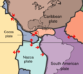
the Sinú-San Jacinto Basin and Lower Magdalena Valley in the west from the Sierra Nevada de Santa Marta to the east. The buried Algarrobo Fault segment...
34 KB (2,441 words) - 03:23, 8 July 2024

Berkeley, California (category Cities in the San Francisco Bay Area)
by the Hayward Fault Zone, a major branch of the San Andreas Fault to the west. No large earthquake has occurred on the Hayward Fault near Berkeley in...
131 KB (13,213 words) - 23:11, 14 August 2024
Geology and geological history of California (section San Francisco Bay, San Pablo Bay and Suisun Bay)
mountain ranges. One of the most important events was the advent of the San Andreas Fault around 29 million years ago in the Oligocene, when the region subducted...
30 KB (4,556 words) - 02:59, 28 June 2024
Chixoy-Polochic fault". Bulletin of the Seismological Society of America. 75 (2). Seismological Society of America: 455–473. White, Randall A.; Juan Pablo Lígoria;...
12 KB (693 words) - 01:13, 12 August 2024
of the San Diego Natural History Museum. The land on which San Diego–Tijuana sits is due west of a major transform fault. The transform fault, known as...
123 KB (11,855 words) - 23:27, 13 August 2024
Hills in the San Francisco Bay Area, situated in Contra Costa County, California. The canyon is bounded on its east side by the San Pablo Ridge, and is...
2 KB (303 words) - 20:07, 30 January 2024

$210,500,000 in 2023). It would have spanned San Pablo Bay from Castro Point (Contra Costa County) to Point San Quentin (Marin County), approximately the...
69 KB (7,248 words) - 02:23, 12 May 2024
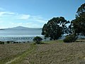
Point Pinole Regional Shoreline (category San Pablo Bay)
Shoreline is a regional park on the shores of the San Pablo Bay, California (the northern arm of the San Francisco Bay), in the United States. It is approximately...
11 KB (1,304 words) - 19:39, 28 November 2023
found in San Pablo, Nariño. The activity of the volcano has been noted as prehistoric. The volcanoes are located between the El Tablón Fault to the west...
4 KB (245 words) - 22:24, 2 July 2024

Guatemala to central Panama. Due to the presence of several active geologic faults and the Central America Volcanic Arc, there is a high amount of seismic...
108 KB (7,917 words) - 17:47, 16 August 2024
The Romeral Fault System (Spanish: Sistema de Fallas (de) Romeral) is a megaregional system of major parallel and anastomosing faults in the Central Ranges...
34 KB (3,320 words) - 20:11, 2 July 2024
showed a group of men storming the house of 48-year-old Ricardo Lasco in San Pablo, Laguna. Several minutes later, Lasco was escorted out of the house with...
23 KB (1,953 words) - 15:57, 5 August 2024

Berkeley Hills (category Mountain ranges of the San Francisco Bay Area)
to be part of the Berkeley Hills, is actually located on the adjacent San Pablo Ridge[dubious – discuss] near the point where it meets the Berkeley Hills...
13 KB (1,462 words) - 22:20, 14 August 2024

the southern coast of Wager Island— is the Liquiñe-Ofqui Fault system, a major geological fault that exhibits current seismicity. Three tectonic plates...
27 KB (2,533 words) - 20:27, 26 May 2024