
Sandy Hook is a barrier spit in Middletown Township, Monmouth County, New Jersey, United States. The barrier spit, approximately 6 miles (9.7 km) in length...
22 KB (2,021 words) - 02:21, 3 August 2024

U.S. Route 340 (redirect from Sandy Hook Bridge)
however, the U.S. highway's bridge was destroyed by a flood in 1936. The modern US 340 Bridge was constructed at Sandy Hook between 1940 and 1947, with...
61 KB (5,642 words) - 03:15, 29 August 2024

Gunnison Beach (redirect from Gunnison Beach, Sandy Hook, NJ)
a beach within the Sandy Hook unit of the Fort Hancock and the Sandy Hook Proving Ground Historic District which is the Sandy Hook Unit of Gateway National...
6 KB (749 words) - 21:28, 11 August 2024

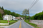
Sandy Hook is a village in the town of Newtown, Connecticut, founded in 1711. It was listed as a census-designated place prior to the 2020 census. According...
12 KB (952 words) - 21:55, 16 July 2024

The Sandy Hook Proving Ground was a military facility along the Atlantic coast of New Jersey established by the Secretary of War on August 7, 1874, to...
14 KB (1,429 words) - 23:34, 19 April 2023
miles (4.8 km) to the west, across the bridge, a special train that had carried soldiers was parked at Sandy Hook, and it carried the telegraph that reporters...
5 KB (275 words) - 01:36, 8 April 2024

Raritan Bayshore (redirect from Sandy Hook Bay)
The Amboys to Sandy Hook, in Middlesex and Monmouth counties, including the towns of Perth Amboy, South Amboy, Sayreville, Old Bridge, Matawan, Aberdeen...
17 KB (1,502 words) - 22:46, 11 May 2024

the entrance to Sandy Hook. The span is part of Route 36. Several bridges have occupied the site. The first was a wooden beam bridge which lasted three...
7 KB (765 words) - 11:48, 2 May 2024

city. The city classifies Red Hook Houses as being in flood zone 1, indicating high flood risk. Before Hurricane Sandy in 2012, various city reports had...
16 KB (1,493 words) - 00:31, 29 June 2024

course along the western side of Jack Mountain (4,045 ft), followed by Sandy Ridge (2,297 ft) along U.S. Route 220. North of the confluence of the South...
90 KB (6,101 words) - 06:39, 28 August 2024
Brooklyn Bridge has 135 feet (41.1 m) of clearance, while the Bayonne Bridge has been raised from 155 feet (47.2 m) to 215 feet (65.5 m). The Sandy Hook Pilots...
76 KB (7,135 words) - 09:03, 1 September 2024

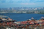
Brooklyn). The eastern end of the Bay is marked by two spits of land, Sandy Hook, New Jersey, and Rockaway, Queens. The waterway between the spits connects...
7 KB (837 words) - 20:36, 15 April 2024

Little Red Lighthouse (redirect from Jeffrey's Hook Lighthouse)
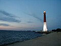
Jeffrey's Hook was acquired by the city in 1896 and later became Fort Washington Park. The early structure was built as the North Hook Beacon at Sandy Hook, New...
10 KB (1,183 words) - 17:28, 4 January 2024

Hurricane Sandy (unofficially referred to as Superstorm Sandy) was an extremely large and destructive Category 3 Atlantic hurricane which ravaged the...
215 KB (19,375 words) - 01:25, 1 September 2024
Hillsboro, to its northern terminus at U.S. Route 340, south of the Sandy Hook bridge over the Potomac River and east of Harpers Ferry. State Route 719...
5 KB (526 words) - 15:22, 16 January 2024

Shrewsbury River (section Bridges)
River estuary, then entering 1 mi (1.6 km) north in a narrow channel to Sandy Hook Bay at Highlands. The south shore runs about the entire length of the...
4 KB (290 words) - 16:34, 9 June 2024

In 2010, Red Hook's first community newspaper, The Red Hook Star-Revue, began publication. Red Hook was heavily damaged by Hurricane Sandy in 2012, two...
59 KB (6,244 words) - 05:45, 21 May 2024
Jersey Shore (section Sandy Hook (Middletown))
Highlands, which overlooks where the Atlantic Ocean and Raritan Bay meet at Sandy Hook, contains Mount Mitchill, the highest point on the eastern seaboard south...
75 KB (7,358 words) - 05:56, 28 July 2024
Crossing, crossing the Potomac River between Sandy Hook, Maryland, and Harpers Ferry, West Virginia B&O Railroad Bridge, crossing the Schuylkill River in Philadelphia...
677 bytes (122 words) - 08:15, 25 July 2022
List of crossings of the Potomac River (redirect from Potomac River Bridges)
This is a list of bridges and other crossings of the Potomac River and its North and South branches. Within each section, crossings are listed from the...
24 KB (115 words) - 12:12, 9 November 2023

harbor pilot who guided large vessels into and out of New York Harbor as a Sandy Hook pilot. During his long career his work included bringing the ship that...
28 KB (2,502 words) - 21:59, 26 August 2024
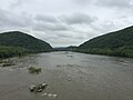
Potomac Water Gap View of the gap from the Sandy Hook Bridge (U.S. Route 340) Elevation 256 feet (78 m) Traversed by U.S. Highway 340 Location Loudoun...
4 KB (377 words) - 16:44, 3 October 2022

severely affected by Hurricane Sandy on October 29–30, 2012, particularly New York City, its suburbs, and Long Island. Sandy's impacts included the flooding...
91 KB (9,006 words) - 01:11, 1 September 2024

Harbor Defenses of New York (redirect from Harbor Defenses of Sandy Hook)
Defenses of Southern New York in 1913. Circa 1915 the Coast Defenses of Sandy Hook separated from the latter command. In 1925 the commands were renamed as...
83 KB (10,829 words) - 22:00, 11 July 2024

of Sandy Hook, New Jersey, and Breezy Point, New York. Ambrose Channel terminates at Ambrose Anchorage, just south of the Verrazzano Narrows Bridge, the...
4 KB (378 words) - 14:59, 24 October 2023

two-masted Sandy Hook pilot boat, built in 1867 by John A. Forsyth at Mystic Bridge, New London, Connecticut for New Jersey and Sandy Hook maritime pilots...
8 KB (772 words) - 09:01, 8 September 2023
3 ft (0.91 m) of sand in Keansburg Amusement Park. Hurricane Sandy forced the Sandy Hook section of Gateway National Recreation Area to close for six...
65 KB (6,775 words) - 15:35, 29 August 2024

of the Hackensack River List of crossings of the Lower Passaic River Sandy Hook Pilots Christopher O. Ward Hudson County New Jersey Street Map. Hagstrom...
8 KB (706 words) - 08:51, 1 September 2024

York Skyline and Verrazzano-Narrows Bridge across the Sandy Hook Bay and Raritan Bay. The Highlands-Sea Bright Bridge, which carries Route 36, is nearby...
3 KB (172 words) - 14:47, 24 October 2023
Mechanicsville north over Route 688 to the proposed new Route 340 leading to Sandy Hook Bridge 7.70 State Highway Commission of Virginia (May 12–14, 1954). "Minutes...
29 KB (4,034 words) - 09:04, 30 December 2023