
Santiam Junction is a highway junction and unincorporated community in Linn County, Oregon, United States, at the intersection of U.S. Route 20/Oregon...
12 KB (347 words) - 20:06, 27 February 2024

North Santiam River to Santiam Junction. U.S. Route 20, which follows the South Santiam River from the Albany–Corvallis area to Santiam Junction. Oregon Route...
9 KB (593 words) - 12:47, 1 April 2024

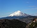
Oregon Route 22 is an Oregon state highway that runs between the Oregon Coast community of Hebo, to a junction with U.S. Route 20 near Santiam Pass in...
14 KB (918 words) - 03:43, 15 June 2024
Santiam Academy Santiam Hospital Santiam Junction, Oregon Santiam Junction State Airport Santiam Pass Santiam River Santiam State Forest This disambiguation...
325 bytes (71 words) - 03:54, 2 September 2014
Santiam Junction State Airport (ICAO: 8S3) is a public airport located adjacent to Santiam Junction in Linn County, Oregon, United States. Santiam Junction...
2 KB (149 words) - 20:06, 27 February 2024

Albany–Corvallis Highway No. 31 (February 2012) Albany–Junction City Highway No. 58 (March 2016) Santiam Highway No. 16 (August 2015) McKenzie Highway No. 15...
19 KB (951 words) - 22:11, 20 August 2024

Ghosts of Highway 20 (category Crime in Oregon)
interviewed Ackroyd who got off of work at 6:30 a.m. He was based in Santiam Junction, Oregon and drove to Camp Sherman, about 25 miles from work. He said that...
21 KB (2,735 words) - 23:10, 28 August 2024

Wilderness, including Santiam Lake Trail #3491. It is located about 6.5 miles northwest of Santiam Junction, Oregon. List of lakes in Oregon "Mount Jefferson...
3 KB (134 words) - 02:28, 21 August 2023

29 kilometres (18 mi) southwest of Mount Jefferson and east of Santiam Junction, Oregon, United States. Geologically, much of the area surrounding the...
4 KB (321 words) - 05:57, 5 December 2023

The Middle Santiam River is a tributary of the South Santiam River, 38.5 miles (62.0 km) long, in western Oregon in the United States. It drains a remote...
6 KB (358 words) - 06:01, 5 December 2023

The McKenzie Pass–Santiam Pass Scenic Byway is an 82-mile-long (132 km) National Scenic Byway in the U.S. state of Oregon. The route is a loop designed...
5 KB (235 words) - 18:26, 21 August 2023

begins a concurrency that continues through Santiam Junction (the terminus of OR 22) and Sisters as Santiam Highway No. 16. OR 242 is an alternative route...
34 KB (3,462 words) - 03:43, 15 June 2024

dangerous Columbia River. In Central Oregon there was the Santiam Wagon Road (established 1861), which roughly parallels Oregon Highway 20 to the Willamette Valley...
42 KB (5,907 words) - 13:44, 12 June 2024
John Arthur Ackroyd (category Crime in Oregon)
Rachanda and Byron. They lived at Santiam Junction, a state highway division compound at the junction of an Oregon 126, Oregon 22, and U.S. Highway 20. Other...
6 KB (544 words) - 04:10, 24 August 2024

Oregon (/ˈɒrɪɡən, -ɡɒn/ ORR-ih-ghən, -gon) is a state in the Pacific Northwest region of the United States. It is a part of the Western U.S., with the...
196 KB (16,672 words) - 19:48, 29 August 2024

gravel road heading north from Belknap Springs to U.S. Route 20 at Santiam Junction was widened and paved. At that point, the new alignment was designated...
9 KB (730 words) - 01:56, 8 August 2023

and the town of Mehama along the Santiam River. The highway is also known as the Albany–Lyons Highway No. 211 (see Oregon highways and routes), and is 25...
2 KB (169 words) - 09:25, 23 June 2023
Minto Lavas, made of basalt, followed by the Santiam basalts, named for their movement into the North Santiam River valley, which they filled to depths of...
58 KB (6,630 words) - 01:30, 28 August 2024

additional track was laid over Santiam Pass. Hogg had mules pull some cars a few times to assert right of way. Hogg Rock near Santiam Pass is named for T. Egenton...
8 KB (713 words) - 01:56, 8 August 2023

final leg of the Oregon Trail. The Applegate Trail and Santiam Wagon Road were constructed soon after, connecting eastern and western Oregon in the southern...
24 KB (2,303 words) - 03:58, 8 June 2024

the Pee-you. It is likely that since the Santiam had an alliance with the Brownsville Kalapuyans that the Santiam influence also went as far at Eugene. According...
153 KB (13,585 words) - 16:07, 27 August 2024

Kingston Marion Forks Riverside Santiam Junction Berlin National Register of Historic Places listings in Linn County, Oregon USS Linn County (LST-900) "State...
21 KB (1,827 words) - 16:20, 29 August 2024

Saint Paul - Salem - Salisbury - Salt Creek - Sams Valley - Sandy - Santiam Junction - Scappoose - Scholls - Scio - Scotts Mills - Scottsburg - Seal Rock...
41 KB (1,679 words) - 00:03, 20 July 2024

Cave Junction, on Oregon Route 46. The protected area, managed by the National Park Service (NPS), is in southwestern Josephine County, near the Oregon–California...
51 KB (5,215 words) - 00:26, 20 July 2024

Warriors Yamhill-Carlton Tigers Amity Warriors Dayton Pirates Jefferson Lions Santiam Christian Eagles (private) Scio Loggers Sheridan Spartans Taft Tigers Creswell...
41 KB (2,269 words) - 14:41, 6 May 2024

Department of Transportation. Retrieved January 12, 2021. "NORTH SANTIAM HIGHWAY No. 162" (PDF). Oregon Department of Transportation. Retrieved January 12, 2021...
8 KB (765 words) - 05:27, 26 February 2024

dangerous Columbia River. In Central Oregon, there was the Santiam Wagon Road (established 1861), which roughly parallels Oregon Highway 20 to the Willamette...
144 KB (19,253 words) - 07:09, 1 August 2024

Detroit Lake (redirect from Detroit Lake, Oregon)
Detroit Dam on the North Santiam River 46 miles (74 km) southeast of Salem, Oregon, United States. The lake is adjacent to Oregon Route 22 near the city...
8 KB (591 words) - 11:21, 30 April 2024

The Oregon Dunes National Recreation Area is located on the Oregon Coast, stretching approximately 40 miles (64 km) north of the Coos River in North Bend...
16 KB (1,678 words) - 19:22, 4 August 2024

The Middle Santiam Wilderness is a wilderness area located near Mount Washington in the central Cascade Range of Oregon, U.S., within the Willamette National...
3 KB (216 words) - 11:04, 28 August 2024