
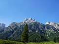
Schrofen, a German mountaineering term, is steep terrain, strewn with rocks and rock outcrops, that is laborious to cross, but whose rock ledges (schrofen)...
2 KB (229 words) - 19:04, 11 November 2023

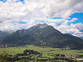
The Schrofen Pass (German: Schrofenpass) is a pedestrian pass (el. 1,688 m) across the Allgäu Alps. It connects Oberstdorf in Germany with Warth in Austria...
2 KB (62 words) - 12:30, 11 August 2024

Haldenwanger Eck, Germany's southernmost point. At the end of the valley the Schrofen Pass leads to Austria. The Allgäu Alps in the area around Oberstdorf attain...
15 KB (1,267 words) - 15:32, 14 February 2024

cross with a summit register. Cross, west of the summit, with Wampeter Schrofen Summit cross of the Hinterer Tajakopf Rudolf Wutscher: Mieminger Kette...
3 KB (207 words) - 15:49, 8 April 2022

must be able to do this on all types of terrain, including scree, rock, schrofen, bare earth or firn, and also in wet conditions. An ability to recognise...
6 KB (667 words) - 11:37, 1 August 2024

the south over the col of Biberwierer Scharte (2,000 m) is the Wampeter Schrofen (2,520 m). The summit may be ascended from the Coburger Hut (1,917 m) on...
4 KB (317 words) - 15:30, 2 November 2023
Its North Face is around 200 metres high and its South Face has a more schrofen-like character. With the almost equally high Upsspitze (2,332 m) it forms...
3 KB (308 words) - 16:15, 14 July 2024

mountain tour that requires Alpine experience. The ascent crosses a grass and schrofen covered ridge east of the Vogelkar cirque. Just below the summit there...
4 KB (285 words) - 16:19, 14 July 2024

carbonate (and later tungsten) were mined around the Alpine pastures of the Schrofen and Wangl Almen above the Tuxertal A ropeway conveyor of more than 9 km...
10 KB (1,270 words) - 16:42, 14 July 2024

ascend from the south following a faint path through broken rubble and schrofen terrain with climbs of UIAA grade I to the start of the vertical summit...
4 KB (328 words) - 14:12, 17 August 2024

winter Highest point Elevation 2,533 m (AA) (8,310 ft) Prominence 845 m ↓ Schrofen Pass Isolation 6.0 km → Mohnenfluh Coordinates 47°17′06″N 10°07′45″E /...
6 KB (654 words) - 14:11, 5 April 2023

(Kitzbühel District) Austria Walserberg Austria Inn Valley Autobahn Schrofen Pass Steinpass Ursprung Pass Ausserfern Railway (S7) Mittenwald Railway...
9 KB (772 words) - 19:01, 24 July 2024
contrast, to the north and east it descends relatively gently down grass and schrofen slopes to the broad plateau of the Tennen Mountains. The double summit...
4 KB (292 words) - 12:09, 18 December 2023

2015 it was additionally fed between April and August from the Blauer Schrofen spring below the Seefelder Spitze. The additional water from the Kaltwassersee...
33 KB (2,342 words) - 06:27, 30 July 2024

side of the Kleiner Solstein facing the Inn valley is characterised by schrofen and steep-sided cirques. To the north it plummets in a rock face up to...
4 KB (299 words) - 16:23, 14 July 2024

discernible path leads to the top in about 2 hours passing across the schrofen covered southwest slopes. The rather longer climb from the Selenitza Saddle...
5 KB (435 words) - 17:17, 14 July 2024

rock formation, known as main dolomite. It begins at the saddle of the Schrofen Pass at the head of the Rappenalpen valley and runs largely in a straight...
33 KB (4,252 words) - 12:54, 4 August 2024

summit block, whose mighty rock faces and steep, rugged, rocky flanks (Schrofen) fall away on all sides. Its 1,200-metre-high (3,900 ft) south cliff face...
6 KB (566 words) - 16:51, 14 July 2024

mountains north of Leutasch are very interesting, especially the Oberreintal-Schrofen, the Scharnitzspitze and the Schüsselkarspitze. On the south faces of these...
14 KB (1,398 words) - 16:13, 14 July 2024

from the main summit to the East Top requires sure-footed negotiation of schrofen terrain and, at one spot, climbing to grade II standard and is only recommended...
3 KB (286 words) - 16:16, 14 July 2024
Tajakopf (2,408 m) 2 hours Vorderer Drachenkopf (2,301 m) 1 hour Wampeter Schrofen (2,520 m) 2.5 hours Over the Hinterer Tajatörl and Igelsscharte col to...
7 KB (776 words) - 16:10, 14 July 2024

secondary peak situated on a ridge which runs southwest from Riffenkopf to Schrofen at which point the ridge falls off steeply. The ridges connecting Riffenkopf...
2 KB (162 words) - 16:15, 20 December 2019

meadow of Steiner-Hochalm and across the steep, sunny, but less arduous schrofen on the southern flank of the mountain up to the summit cross. Duration:...
3 KB (256 words) - 16:23, 14 July 2024

route is graded as UIAA II+ and takes just under 2 hours through steep schrofen terrain over the northwest flank to reach the top. An alternative climb...
5 KB (376 words) - 16:24, 14 July 2024

unmarked path to the unprominent southwestern arête and then on grassy schrofen to the two summits. On the north top there is a metal orientation rose...
3 KB (199 words) - 16:17, 14 July 2024

15.5 km south-southwest of Oberstdorf and only about 2.5 km east of the Schrofen Pass. The Biberkopf is sometimes described as the most southerly point...
4 KB (397 words) - 16:15, 14 July 2024

534 m (AA)) above Innsbruck and poses no great difficulties. It runs through schrofen terrain up to the Gamswart Saddle, then for a short way along the western...
4 KB (247 words) - 16:25, 14 July 2024

runs from the Ingolstädter Haus along the steep southern flank across schrofen and scree taking a good hour to reach the summit. The Ingolstädter Haus...
6 KB (421 words) - 16:52, 14 July 2024

characterised by steep rock faces, to the south, steep grassy mountainsides and schrofen terrain dominates. The highest point of the Hochplattig is its rather indistinct...
5 KB (495 words) - 16:18, 14 July 2024

table: ^a Only includes Reformed Church members. The Bohlenständerhaus Schrofen, Sallmann Carriage Collection and Hagenwil Castle are listed as Swiss heritage...
22 KB (2,783 words) - 20:08, 22 March 2024