
1°49′07″E / 43.35071°N 1.81862°E / 43.35071; 1.81862 The Seuil de Naurouze, or Col de Naurouze, is the highest point (190 m above sea level) of the Canal...
3 KB (347 words) - 10:04, 23 April 2021

Canal du Midi (category CS1 German-language sources (de))
to convey water from the Montagne Noire (Black Mountains) to the Seuil de Naurouze, the highest point of the canal. The Canal du Midi was inscribed as...
104 KB (14,963 words) - 01:48, 25 August 2024

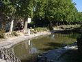
The flow of water from the Bassin de Saint-Ferréol joins the Canal du Midi at this point near the Seuil de Naurouze. Riquet hoped to build a city around...
2 KB (208 words) - 18:59, 17 November 2022
European watershed (category CS1 German-language sources (de))
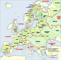
catchment areas of the Garonne (with the summit of the Canal du Midi at Seuil de Naurouze), Loire and Seine in the west and that of the Rhone in the east, marked...
10 KB (1,143 words) - 23:07, 1 May 2024
tank, called the Bassin de Naurouze, created during the building of the Canal du Midi. It is in the area of the Seuil de Naurouze on a mountain pass in...
1 KB (114 words) - 13:50, 28 February 2015

interface of the Aquitaine Basin and the Paris Basin.To the east, the seuil de Naurouze (or Lauragais) is located on the border of the departments of Haute-Garonne...
14 KB (1,623 words) - 17:55, 10 June 2024

Canal du Midi from Toulouse (1), through the summit of the canal at Seuil de Naurouze (2), Castelnaudary (3), then Carcassonne (4) and Trèbes (5). The channel...
20 KB (889 words) - 15:28, 28 December 2022

Aude (redirect from Département de l'Aude)
Ocean to the Mediterranean Sea. It comes into the west of Aude at Seuil de Naurouze then joins the Mediterranean at Sète. The people of Aude expressed...
53 KB (5,680 words) - 02:38, 21 August 2024

the Mediterranean-Atlantic watershed boundary near Seuil de Naurouze. He was inspired by Adam de Craponne's theories, which had been used earlier by...
11 KB (1,413 words) - 03:50, 2 August 2024
located in the commune of Montferrand, Aude. Locks on the Canal du Midi Seuil de Naurouze 43°21′19″N 1°49′5″E / 43.35528°N 1.81806°E / 43.35528; 1.81806...
760 bytes (87 words) - 14:53, 29 April 2022
trending Pyrenees. In the southeast, the basin reaches the Seuil de Naurouze (also called Seuil du Lauragais) between the Montagne Noire on its northern...
48 KB (6,285 words) - 14:05, 21 May 2024
Water features on the Canal du Midi (redirect from Épanchoir de Villepinte)
ISBN 2-913120-04-0. Vois Navigables Canaux du Midi. Editions De L'Ecluse. 2008. ISBN 978-2-916919-09-6. CanalMidi.com The Canal du Midi - "Seuil de Naurouze"...
5 KB (280 words) - 10:25, 10 July 2023

rises in the south-east of the commune which is not far from the Seuil de Naurouze - the highest point on the Canal du Midi between the Atlantic and...
27 KB (3,282 words) - 08:17, 2 October 2024