
The Shire of Corangamite is a local government area in the Barwon South West region of Victoria, Australia, located in the south-western part of the state...
10 KB (423 words) - 23:12, 2 March 2024
Corangamite may refer to: Division of Corangamite Lake Corangamite Corangamite Shire Corangamite Catchment Management Authority This disambiguation page...
166 bytes (46 words) - 03:44, 28 December 2019

(1886–1903) • Cundare North (1911–1969 North Cundare) • Dreeite (1912–1971 Corangamite, North Dreeite) • Dreeite South (1925–1934) • Elliminyt (1879–1993...
136 KB (12,146 words) - 05:09, 28 June 2024
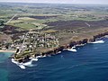
Port Campbell (category Shire of Corangamite)
Great Ocean Road, west of the Twelve Apostles, in the Shire of Corangamite. At the 2016 census, Port Campbell had a population of 478. The port and the...
6 KB (411 words) - 10:25, 7 May 2023

The Twelve Apostles (Victoria) (category Stacks of Australia)
The Twelve Apostles are a collection of limestone stacks off the shore of Port Campbell National Park, by the Great Ocean Road in Victoria, Australia....
10 KB (731 words) - 11:32, 9 April 2024

The Division of Wannon is an Australian Electoral Division in the state of Victoria. The division was proclaimed in 1900, and was one of the original...
10 KB (356 words) - 14:01, 26 April 2024

Plains Shire, where it includes the towns of Bannockburn, and Inverleigh. Since the 2019 federal election, the current Member for Corangamite is Libby...
17 KB (1,012 words) - 09:15, 3 June 2024

Camperdown, Victoria (category Shire of Corangamite)
the area around Princetown on the Great Ocean Road into the Shire of Corangamite. The Town of Camperdown was not subdivided into wards, and the nine councillors...
20 KB (1,853 words) - 11:21, 1 August 2024

Skipton, Victoria (category Shire of Corangamite)
52 kilometres south west of the regional centre, Ballarat. Skipton is in the Shire of Corangamite LGA and is on the banks of Mount Emu Creek. At the 2016...
8 KB (498 words) - 04:59, 7 March 2024

Terang (category Shire of Corangamite)
Western District of Victoria, Australia. The town is in the Shire of Corangamite and on the Princes Highway 212 kilometres (132 mi) south west of the state's...
13 KB (1,014 words) - 20:18, 7 July 2024

Timboon (category Shire of Corangamite)
District of Victoria, Australia. The town is in the Shire of Corangamite local government area, and is approximately 213 kilometres (132 mi) south-west of the...
10 KB (960 words) - 22:51, 9 July 2024
Ayrford, Victoria (category Shire of Corangamite)
in the Barwon South West region of Victoria, Australia. It is located between the Shire of Corangamite and the Shire of Moyne. The Ayrford post office...
2 KB (123 words) - 12:43, 5 September 2023

The electoral district of South-West Coast is an electorate of the Victorian Legislative Assembly. It was created prior to the 2002 election in order...
4 KB (222 words) - 13:20, 15 August 2024

Cobden, Victoria (category Shire of Corangamite)
Victoria" (PDF). Auditor-General of Victoria. 1986. p. 78. Retrieved 12 April 2020. Department of Primary Industry, Corangamite, retrieved 21 July 2008 Full...
7 KB (611 words) - 12:14, 7 May 2024

Barwon South West (region) (category Regions of Victoria (state))
2011 census, the Barwon South West region includes the Colac Otway, Corangamite, Glenelg, Greater Geelong, Moyne, Queenscliffe, Southern Grampians, Surf...
12 KB (752 words) - 04:09, 19 August 2023
Princetown, Victoria (category Shire of Corangamite)
Great Ocean Road, east of the Twelve Apostles, in the Corangamite Shire. Princetown is located 14 kilometres (8.7 mi) east of Port Campbell in Victoria...
4 KB (286 words) - 10:25, 7 May 2023

Derrinallum (category Shire of Corangamite)
Hamilton Highway, in the Corangamite Shire. The town is the centre for the surrounding farming community and lies at the foot of Mount Elephant. Mount Elephant...
10 KB (1,050 words) - 18:13, 12 August 2024
Ecklin South, Victoria (category Shire of Corangamite)
the Western District of Victoria, Australia. It is located mostly in the Shire of Corangamite with a small portion in the Shire of Moyne. The first school...
2 KB (156 words) - 12:42, 5 September 2023
Shire of Central Goldfields) Corangamite Moyne Library Service (Shire of Corangamite and Shire of Moyne) East Gippsland Shire Library (Shire of East Gippsland)...
17 KB (1,252 words) - 19:42, 12 July 2024
Darlington, Victoria (category Shire of Corangamite)
District of Victoria, Australia. The locality is in the Shire of Corangamite and on the Hamilton Highway, 194 kilometres (121 mi) south west of the state...
4 KB (161 words) - 07:38, 11 January 2024
Foxhow, Victoria (category Shire of Corangamite)
Australia, located 200 km south-west of Melbourne in an agricultural area at the northern end of Lake Corangamite. Foxhow Post Office opened around 1902...
2 KB (85 words) - 10:17, 17 May 2024

Lismore, Victoria (category Shire of Corangamite)
(106 mi) west of Melbourne. It is part of the Corangamite Shire local government area. At the 2016 census, Lismore had a population of 420. Its Aboriginal...
10 KB (722 words) - 20:22, 7 July 2024

(24 mi) north of Colac on the Ballarat road. It is divided between Golden Plains Shire, the Shire of Colac Otway, and Corangamite Shire. At the 2016 census...
7 KB (595 words) - 02:15, 21 February 2024

Noorat (category Shire of Corangamite)
Australia. Noorat is located approximately 211 km west of Melbourne. The township is located at the base of Mount Noorat, a dormant volcano, which is considered...
5 KB (508 words) - 10:06, 7 May 2023
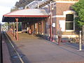
Terang railway station (category Shire of Corangamite)
Victoria, Australia. It serves the town of Terang, and it opened on 23 April 1887. Terang opened as the terminus of the line from Camperdown. On 4 February...
6 KB (368 words) - 12:49, 7 May 2024

Jancourt East (category Shire of Corangamite)
the Corangamite Shire, 203 kilometres (126 mi) south west of the state capital, Melbourne. At the 2016 census, Jancourt East had a population of 188....
1 KB (66 words) - 06:05, 11 May 2023

covers the Colac and Corangamite local government areas (LGA), parts of the Moyne, Golden Plains and Surf Coast LGAs, and slivers of the Ararat and Greater...
8 KB (380 words) - 13:19, 15 August 2024
the Shire of Corangamite and was duly elected to serve for one term until 2020. In 2016, Simon also identified and warned of the rising number of international...
6 KB (479 words) - 12:40, 3 July 2024
Brucknell, Victoria (category Shire of Corangamite)
Brucknell is a locality in the Western District of Victoria, Australia. It is located in the Shire of Corangamite and Moyne. The formally recognised traditional...
2 KB (136 words) - 06:24, 9 July 2023
Cooriemungle, Victoria (category Shire of Corangamite)
is a locality within the Shire of Corangamite in Victoria, Australia. At the 2016 census, Cooriemungle had a population of 364. In 1938 the Cooriemungle...
2 KB (165 words) - 09:47, 7 May 2023