
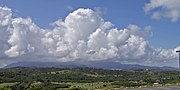
The Sierra de Luquillo (English: "Luquillo Mountains") is a steep-sided, high-precipitation, and deeply-forested subrange of the Cordillera Central mountain...
10 KB (1,049 words) - 22:39, 18 October 2024

Luquillo is spread over 5 barrios and Luquillo Pueblo (the downtown area and the administrative center of the city). It lends its name to the Sierra de...
25 KB (1,952 words) - 15:28, 24 January 2025
El Yunque National Forest (redirect from Luquillo National Forest)
Service. El Yunque National Forest is located on the slopes of the Sierra de Luquillo mountains, encompassing more than 28,000 acres (43.753 mi2 or 113...
58 KB (6,107 words) - 16:32, 3 February 2025

bull) is 3,526 feet (1,075 m) high and is the highest peak in the Sierra de Luquillo mountains in eastern Puerto Rico. The peak is located in the boundaries...
3 KB (208 words) - 01:55, 31 August 2024
feet) above sea level is not the highest in Puerto Rico or even the Sierra de Luquillo range where it is located. It is however the most famous peak due...
7 KB (667 words) - 21:01, 9 February 2025

northeastern Puerto Rico. The experimental forest is located in the Sierra de Luquillo some 50 km (30 mi) east of San Juan, the capital of the island. It...
9 KB (992 words) - 12:11, 12 July 2023

Northern coastal plain and Sierra de Luquillo Canóvanas, Loíza, Rio Grande, and Luquillo Eastern coastal plain and Sierra de Luquillo Fajardo, Ceiba, and Naguabo...
35 KB (1,837 words) - 09:34, 8 February 2025

center, the Sierra de Cayey in the southeast, and the Sierra de Luquillo in the northeast. The highest elevation point in Puerto Rico, Cerro de Punta (4...
43 KB (4,075 words) - 22:56, 14 February 2025

Caguas, Puerto Rico (section Valle de Caguas)
Rico. Located in the eponymous Caguas Valley between the Sierra de Cayey and Sierra de Luquillo of the Central Mountain Range, it is bordered by San Juan...
65 KB (5,680 words) - 11:43, 27 January 2025

peak of the east) is a mountain peak in the southern portion of the Sierra de Luquillo, located on the boundary between the municipalities of Ceiba and Naguabo...
2 KB (190 words) - 05:36, 27 September 2023

Caguas Valley (redirect from Valle de Caguas)
between two mountain subranges of the Cordillera Central, Sierra de Cayey and Sierra de Luquillo, in the eastern region of the main island of Puerto Rico...
8 KB (692 words) - 00:08, 12 January 2025

Puerto Rico (redirect from Estado Libre Asociado de Puerto Rico)
Cerro de Punta 4,390 feet (1,340 m), is located in this range. Another important peak is El Yunque, one of the highest in the Sierra de Luquillo at the...
257 KB (25,183 words) - 23:39, 24 February 2025

western-central Cordillera Central, the southeastern Sierra de Cayey, and the northeastern Sierra de Luquillo. Bordered by the Northern Karst Belt to the northwest...
49 KB (3,371 words) - 10:49, 26 October 2024
eastern foothills of the Santa Cruz Mountains, California El Toro (Sierra de Luquillo), a peak in the El Yunque National Forest in Puerto Rico Cerro El...
2 KB (373 words) - 23:30, 11 September 2021
north of the Sierra de Luquillo. A large portion of El Yunque National Forest and some of the highest points of the Sierra de Luquillo are located within...
28 KB (2,142 words) - 05:17, 31 December 2024

Dominican Republic Sierra de Cayey, Puerto Rico Sierra de Luquillo, Puerto Rico Sierra del Escambray, Cuba Sierra Maestra, Cuba Sierra del Rosario, Cuba...
53 KB (4,869 words) - 06:40, 26 February 2025
Mountains) Sierra Bermeja Sierra de Cayey Sierra de Guardarraya Sierra de Jájome Sierra de Luquillo Sierra de Naranjal Puerto Rico portal Geography portal...
2 KB (175 words) - 11:26, 17 September 2022
coastal plain on the boundary between the Northern Karst Belt and Sierra de Luquillo, it is north of Caguas and Gurabo, southeast of San Juan, and west...
51 KB (4,147 words) - 11:45, 27 January 2025

biggest resorts in the Caribbean. El Toro, the highest point in the Sierra de Luquillo, is located in the boundary between the municipalities of Las Piedras...
24 KB (1,758 words) - 03:14, 11 February 2025

Asociado de Puerto Rico Departamento de Recursos Naturales y Ambientales. Retrieved 24 August 2020. Weaver, Peter L. "La sierra de Luquillo: los recursos...
2 KB (126 words) - 19:42, 19 April 2023

periods by being deciduous or semi-deciduous. Montane forests cover the Sierra de Luquillo and the higher peaks of the Cordillera Central. Trees at middle elevations...
5 KB (510 words) - 16:31, 12 August 2024
Eleutherodactylus portoricensis (redirect from Coqui De La Montaña)
Puerto Rican robber frog. The species’ range spans the Luquillo Mountains (Sierra de Luquillo) of northeastern Puerto Rico and the Cordillera Central...
7 KB (807 words) - 08:35, 16 September 2024

the Sierra de Luquillo in northeastern Puerto Rico, the Cayey mountain range is the smaller subrange of the Cordillera Central. The Rio Grande de Loíza...
4 KB (355 words) - 06:26, 8 September 2024

National Forest (formerly known as the Caribbean National Forest) on the Sierra de Luquillo in eastern Puerto Rico. El Toro, named after the highest peak in the...
7 KB (797 words) - 00:38, 28 October 2024

Cerro Las Tetas (redirect from Las Tetas De Cayey)
peaks are part of the Sierra de Cayey (or Cayey Range). The Sierra de Cayey, like the Cordillera Central and Sierra de Luquillo ranges, extends over several...
11 KB (1,083 words) - 17:22, 23 October 2024

the Sierra de Luquillo to the east, and of other municipalities, such as Cataño and Bayamón to the west. Fuente Raíces (Roots Fountain) on Paseo de la...
13 KB (1,219 words) - 20:56, 23 September 2024

in the Sierra de Luquillo, the rain was over 25 inches (640 mm), with 29.60 in (752 mm) recorded in Adjuntas. The anemometer located in Puerta de Tierra...
70 KB (7,992 words) - 17:51, 8 February 2025

located immediately to the southeast of El Yunque's main peak in the Sierra de Luquillo. The peak consists of a high ridge made up of several smaller peaks...
3 KB (292 words) - 01:05, 27 September 2023

bordered by the Sierra de Luquillo to the north and by the Sierra de Cayey to the south. Río Cayaguás Río Emajagua Río Grande de Loíza Río de las Vegas Like...
25 KB (1,783 words) - 05:25, 31 December 2024
Prinair (redirect from Aerolineas de Ponce)
Fajardo waypoint). Six minutes later the aircraft crashed in the Sierra de Luquillo mountains at an elevation of about 2400 feet; all 19 occupants were...
15 KB (1,345 words) - 02:31, 9 December 2024