Spanggur Tso, also called Maindong Tso, Mendong Tso, is a saltwater lake in Rutog County in the Tibet Autonomous Region of China, close to the border...
8 KB (814 words) - 17:30, 27 July 2024

features in this range are Helmet Top, Black Top, Gurung Hill, Spanggur Gap, Spanggur Tso, Rezang La, Rechin La, Rezang La II, etc. China-Claimed-LAC runs...
56 KB (4,527 words) - 14:00, 13 October 2024

2020–2021 China–India skirmishes (section Pangong Tso)
Chushul sector and Kailash Range overlooking Chinese fixtures at Spanggur Gap and Spanggur Tso. India reported a change in status quo in early May 2020. From...
382 KB (31,166 words) - 23:15, 15 October 2024

locations Sirijap Khurnak Fort Rudok Spanggur Tso Tso Moriri Wikivoyage has a listing for Kyago Tso. "Kyagar Tso - Himalayan Lake Details". Himalayan...
4 KB (254 words) - 19:32, 17 July 2024

Pangong Tso & Spanggur Tso Changthang plateau: Tso Kar, Startsapuk Tso, Kyagar Tso, Tso Moriri, Chilling Tso, Ryul lake. Chumathang area: Yaya Tso and Mirpal...
43 KB (4,318 words) - 06:22, 11 October 2024

Sino-Indian border dispute and the Cold War Indian soldiers patrolling Spanggur Tso at the Sino–Indian border in January 1962 Belligerents China India...
152 KB (16,742 words) - 23:53, 16 October 2024

project and its ecological impact in Merak area" (EIA study near Pangong Tso lake, India. CES Technical Report 123). Retrieved 2024-07-05. Ubaskin, A;...
38 KB (3,474 words) - 11:37, 23 September 2024

Kongta La pass. Lakes Pangong Tso Spanggur Tso Kailash Range (Gangdise Shan range): on the southern bank of Pangong Tso begins from Lukung, runs eastward...
33 KB (3,646 words) - 05:14, 30 July 2024

Pangong Tso Spanggur Tso (NI44-9, LN0) Surigh Yilganing Kol (Surigh-yilganing Köl; 萨利吉勒干南库勒湖) (NI44-6) Tianshuihai Tso Tang (NI44-5, LP4)/Tso Thang (到腾格湖)...
21 KB (2,005 words) - 13:58, 30 September 2024
the Kailash Range and joined the Tangre Chu river before draining into Spanggur Tso. A map compiled in 2009 by an amateur cartographer notes the source of...
26 KB (2,951 words) - 22:04, 20 September 2024
No. 44 Squadron IAF airlifted six AMX-13 tanks to armour the gap at Spanggur Tso through makeshift Chushul aerodrome made of (Perforated Steel Plates)...
14 KB (1,170 words) - 02:01, 24 July 2024

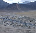
Chinese-administered portions of Ladakh near the village of Chushul and the Spanggur Lake. As of 2020, the Line of Actual Control runs on the north–south ridgeline...
11 KB (1,156 words) - 21:45, 24 September 2024
passes/routes mentioned by Delhi were:[better source needed] Tashigong, Gartok; Spanggur Tso To Rudok; Chiakang, Churkang, Ruksom; Tashigong, Churkang, Ruksom; Rudok...
11 KB (1,137 words) - 20:09, 25 August 2024
township of Rutog contains the Old Rudok town and the valley of Shaldat and Spanggur lakes towards the Ladakh border. It is bounded in the north by the Pangong...
11 KB (1,077 words) - 14:47, 20 October 2024

Sirijap is an alluvial plain on the northern bank of Pangong Tso, which plays a role in the Sino-Indian border dispute in the Ladakh region. India had...
3 KB (247 words) - 23:48, 27 May 2023
Khurnak Fort and Spanggur Tso. 363rd have companies at Kongka La near Gogra/Hot Springs.A patrol boat squadron is deployed on Pangong Tso. 362nd and 363rd...
9 KB (716 words) - 22:44, 6 August 2023
Control south of the Pangong Tso, including at Rezang La and Rechin La. This was said to give them a commanding view of the Spanggur Gap and China's "Moldo...
19 KB (2,045 words) - 00:33, 12 September 2024

Marsimik La Namika La Pensi La Rezang La Rimo Sasser Pass Sia La Shingo La Spanggur Gap Zoji La Mountain peaks Bana Top Chumik Kangri Ghent Kangri Gurung Hill...
3 KB (230 words) - 12:12, 30 October 2023
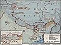
Trig Heights Demchok Chumar opposite Dumchele East of Mt Sajum Spanggur Gap N&S Pangong Tso North of Kugrang River Area of Kongka La 300km 200miles Dibang...
52 KB (4,936 words) - 23:46, 15 October 2024
Marsimik La Namika La Pensi La Rezang La Rimo Sasser Pass Sia La Shingo La Spanggur Gap Zoji La Mountain peaks Bana Top Chumik Kangri Ghent Kangri Gurung Hill...
8 KB (705 words) - 18:42, 16 October 2024
Officials, Indian Report, Part 2 (1962), p. 12–13: "The pastures in the Spanggur area have been the close preserve of the inhabitants of Chushul; and the...
23 KB (2,503 words) - 21:59, 18 April 2024
would appear that the "Rudok" stood for its frontier, somewhere near the Spanggur Gap, and "Pangong Lake" stood for Tangtse, with the Loi Yogma valley in...
33 KB (3,464 words) - 21:54, 20 April 2024
Trig Heights Demchok Chumar opposite Dumchele East of Mt Sajum Spanggur Gap N&S Pangong Tso North of Kugrang River Area of Kongka La 150km 100miles Sakteng...
112 KB (9,779 words) - 23:42, 16 October 2024