
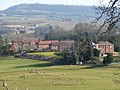
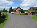
Stockton on Teme is a village and civil parish in the Malvern Hills District in the county of Worcestershire, England. It is close to the River Teme and...
3 KB (237 words) - 21:34, 30 November 2024

Knighton-on-Teme Lower Rochford Newnham Bridge Eastham Eardiston Stockton-on-Teme Stanford Bridge Shelsley Walsh Shelsley Beauchamp Clifton-upon-Teme Whitbourne...
27 KB (2,993 words) - 22:48, 27 January 2025
Stockton on Teme, Worcestershire Stockton-on-the-Forest, North Yorkshire Stockton, Alabama Stockton, California, the largest US city named Stockton Fort...
2 KB (251 words) - 19:47, 14 November 2023

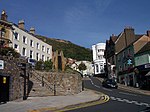
Tenbury Wells (category Coordinates on Wikidata)
the castle that was constructed to defend and control the original River Teme crossing. It has also been described as "... the remains of an 11th-century...
20 KB (2,183 words) - 08:06, 3 February 2025

Malvern Hills District (category Coordinates on Wikidata)
Beauchamp Shelsley Kings Shelsley Walsh Shrawley Stanford with Orleton Stockton-on-Teme Stoke Bliss Suckley Tenbury Upton-upon-Severn Welland West Malvern...
22 KB (1,303 words) - 07:50, 1 February 2025
Stanford on Teme is a village and former civil parish, now in the parish of Stanford with Orleton, in the Malvern Hills district, in the county of Worcestershire...
3 KB (268 words) - 21:57, 18 October 2024

Shelsley Walsh (category Coordinates on Wikidata)
Worcestershire, England, on the western side of the River Teme. For administrative purposes it is presently located in the Teme Valley ward of the county’s...
10 KB (1,170 words) - 06:04, 2 May 2024
Knighton on Teme is a village and civil parish once in the hundred of Doddingtree and now in the Malvern Hills District of the county of Worcestershire...
3 KB (210 words) - 14:57, 7 May 2023

Upton-upon-Severn (redirect from Upton-on-Severn)
Upton on Severn, etc. and locally simply Upton) is a town and civil parish in the Malvern Hills District of Worcestershire, England. Lying on the A4104...
11 KB (932 words) - 16:22, 19 August 2024
Stanbrook, Stanford Bridge, Stanford-on-Teme, Stanklyn, Staple Hill, Stitchin's Hill, Stock Green, Stock Wood, Stockton-on-Teme, Stoke Bliss, Stoke Heath, Stoke...
19 KB (1,173 words) - 06:21, 26 August 2024

Clifton upon Teme is a village and civil parish in the Malvern Hills district in the county of Worcestershire, England. In 2021 the parish had a population...
5 KB (495 words) - 21:09, 28 January 2025
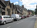
Great Malvern (category Coordinates on Wikidata)
foot of the Malvern Hills, a designated Area of Outstanding Natural Beauty, on the eastern flanks of the Worcestershire Beacon and North Hill, and is the...
64 KB (6,787 words) - 22:39, 4 December 2024

Powick (category Coordinates on Wikidata)
Collett's Green, and Deblins Green. Powick lies on the A449 and has two bridges across the River Teme, one ancient and one modern. The village contains...
9 KB (842 words) - 01:56, 1 February 2024

Martley (category Coordinates on Wikidata)
Details of how to listen and contact the station are on their website. "Teme Valley Geological Society". Teme Valley Geological Society. Morgan, Vanessa 2011...
7 KB (816 words) - 10:02, 7 February 2025

Abberley (category Coordinates on Wikidata)
It is situated on the northern slopes of Abberley Hill, which is 283 metres (928 ft) tall, between the River Severn and River Teme. The civil parish...
10 KB (969 words) - 15:45, 29 August 2024
Orleton; Sapey Pritchard; Shelsley Kings; Shelsley Walsh; Stanford-on-Teme; Stockton-on-Teme; Suckley; Sutton and Tenbury. The lower division consisted of...
3 KB (287 words) - 08:57, 9 October 2024

Lindridge (category Coordinates on Wikidata)
medieval church. Fox, Deborah (2017). "An archaeological enigma from the Teme Valley". Research Worcestershire. Retrieved 1 October 2023. Evans, John (1897)...
4 KB (326 words) - 21:04, 26 November 2024

Barnards Green (category Coordinates on Wikidata)
original on 25 September 2011. Retrieved 17 March 2011. "Malvern bus routes map". Worcestershire County Council. Archived from the original on 30 September...
10 KB (956 words) - 03:28, 21 January 2025

Malvern, Worcestershire (category Coordinates on Wikidata)
the 2021 census it had a population of 30,462. It includes Great Malvern on the steep eastern flank of the Malvern Hills, as well as the former independent...
150 KB (13,974 words) - 19:15, 11 December 2024
Kempsey, Worcestershire (category Coordinates on Wikidata)
the county of Worcestershire, England. It is bounded by the River Severn on the west, and the A38 main road runs through it and is about 3 miles (5 km)...
18 KB (2,336 words) - 21:48, 1 January 2025

Newnham Bridge (category Coordinates on Wikidata)
Newnham Bridge is a village in the parish of Knighton on Teme, near Tenbury Wells, Worcestershire, England, United Kingdom. The village derives part of...
4 KB (395 words) - 06:46, 13 July 2022

Stanford with Orleton (category Coordinates on Wikidata)
Stanford on Teme and Orleton. In 2011 it had a population of 160. The parish was formed on 1 April 1933 from "Orleton" and "Stanford on Teme" parishes...
3 KB (123 words) - 21:57, 18 October 2024

Great Witley (category Coordinates on Wikidata)
extensive views south to the Malvern Hills and over the River Teme valley to the west. On the summit is an Iron Age hillfort. Owain Glyndŵr's army of Welsh...
7 KB (754 words) - 09:59, 7 February 2025

structure's description. Sometimes known as OSGB36, the grid reference is based on the British national grid reference system used by the Ordnance Survey. The...
38 KB (96 words) - 14:24, 15 January 2025
Shelsleys (category Coordinates on Wikidata)
county of Worcestershire, England. Situated on either wide of the Teme Valley near the village of Clifton-upon-Teme, they encompass the formerly distinct civil...
3 KB (273 words) - 14:16, 8 February 2025
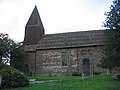
Coates. From 1770 until 1784 he served as rector of the church in Stockton-on-Teme. Around 1785 he left the Church of England to join the Unitarians....
4 KB (343 words) - 00:11, 19 August 2024

Leigh, Worcestershire (category Coordinates on Wikidata)
Worcestershire, England. With just a few hundred inhabitants the parish lies on the A4103, the main Worcester to Hereford road, about 5 miles out of Worcester...
4 KB (372 words) - 12:54, 12 October 2024
Malvern Wells (category Coordinates on Wikidata)
from these places, first being attested in 1831.: 341 Malvern Wells lies on the eastern slopes of the Malvern Hills south of Great Malvern (the town centre...
11 KB (1,268 words) - 10:07, 3 November 2024

Bransford (category Coordinates on Wikidata)
Worcestershire, England. It is situated close to the River Teme and the village of Leigh. It is on the primary route between Worcester and Hereford, the A4103...
12 KB (1,106 words) - 23:41, 1 December 2024
Holt, Worcestershire (category Coordinates on Wikidata)
to the north-west of Worcester, roughly bounded by the rivers Severn and Teme and a line through Broadwas, Martley, Wichenford, Little Witley and Shrawley...
14 KB (1,799 words) - 20:40, 19 January 2025